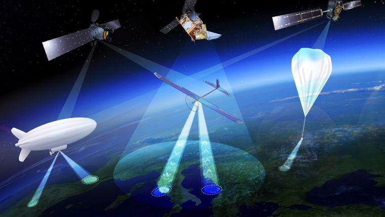
Crossing Drones with Satellites: High-altitude Aerial Platforms
The European Space Agency (ESA) is considering extending its activities to a new region of the sky via a novel type of aerial vehicle, a ‘missing link’ between drones and satellites. High Altitude Pseudo-Satellites, or HAPS, are platforms that float or fly at high altitude like conventional aircraft but operate more like satellites – except that rather than working from space they can remain in position inside the atmosphere for weeks or even months, offering continuous coverage of the territory below.
The best working altitude is about 20km, above the clouds and jet streams, and 10km above commercial airliners, where wind speeds are low enough for them to hold position for long periods. From such a height they can survey the ground to the horizon 500 km away, variously enabling precise monitoring and surveillance, high-bandwidth communications or back up to existing satellite navigation services.
Several ESA directorates have teamed up to investigate their potential, explained future-systems specialist Antonio Ciccolella. For Earth observation, they could provide prolonged high-resolution coverage for priority regions, while for navigation and telecoms they could shrink blind spots in coverage and combine wide bandwidth with negligible signal delay. ESA is looking into how these various domains can be best brought together.
Miniaturisation of Earth observation sensors
Earth observation specialist Thorsten Fehr said experts have been looking into the concept for the last 20 years but now finally it’s becoming reality. That’s come about through the maturing of key technologies: miniaturised avionics, high-performance solar cells, lightweight batteries and harness, miniaturisation of Earth observation sensors and high-bandwidth communication links that can deliver competitively priced services. Navigation engineer Roberto Prieto Cerdeira added there’s obvious potential for emergency response. They could also be employed semi-permanently, perhaps extending satnav coverage into high, narrow valleys and cities.
Zephyr and Stratobus
European companies have already unveiled product lines. For instance, Airbus has developed the winged, solar-powered Zephyr, which in 2010 achieved a world record 14 days of continuous flight without refuelling. Zephyr-S is designed to fly payloads of a few tens of kilograms for up to three months at a time, with secondary batteries employed to keep it powered and aloft overnight. A larger Zephyr-T version in preparation will support larger payloads and power needs.
Thales Alenia Space is meanwhile preparing the lighter-than-air Stratobus, with its first flight expected in 2021. The buoyant Stratobus airship can carry up to 250 kg, its electric engines flying against the breeze to hold itself in position, relying on fuel cells at night.
Source: ESA.

Value staying current with geomatics?
Stay on the map with our expertly curated newsletters.
We provide educational insights, industry updates, and inspiring stories to help you learn, grow, and reach your full potential in your field. Don't miss out - subscribe today and ensure you're always informed, educated, and inspired.
Choose your newsletter(s)


