Cutting-edge Photogrammetry Solutions
nFrames
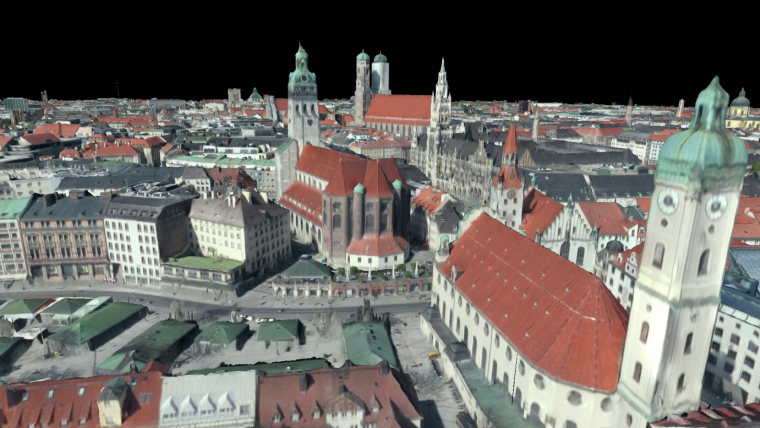
Germany-based technology company nFrames develops cutting-edge 3D surface reconstruction software designed for professional mapping production. Optimised for precision, speed and simplicity, the company’s core software product, SURE, is built to scale for large projects such as countrywide airborne image datasets.
Headquartered in Stuttgart, Germany, nFrames offers a new way for businesses to customise their image surface reconstruction workflows. The company’s SURE software delivers derivation of precise point clouds, DSMs, true orthophotos and textured meshes from small, medium and large-frame images for applications such as nationwide mapping or monitoring projects using manned aircraft and unmanned aerial vehicles (UAVs). nFrames was founded by photogrammetry researchers, specifically to fill in the gaps in dense surface reconstruction for mapping purposes. The aim is to meet the need for precise measurements for each individual pixel efficiently while preserving sharp geometry edges. There are many possible applications, including cadastre, change detection, infrastructure planning, flood analysis, disaster relief, glacier melting, tourism and forestry. This wide range of potential uses has resulted in two licence options for dense 3D surface reconstruction: SURE Aerial for airborne mapping applications, and SURE Professional for close-range applications.
In search of perfect geometry
nFrames is a private company formed in 2013 as a spin-off from the University of Stuttgart’s Institute for Photogrammetry by PhD researchers Konrad Wenzel and Mathias Rothermel. Photogrammetry has traditionally used feature point-based approaches for surface reconstruction from images. However, during their PhD research, Wenzel and Rothermel discovered an unmet market need for solutions providing dense pixel-wise results with reasonable processing times. This spurred the researchers to explore new ways to incorporate their technological developments into business applications and their search for deriving the finest geometry combined with fast and efficient processing continues to this day. The team has since grown to more than ten people with very varied backgrounds and expertise, ranging from research in geomatics and computer science to innovative business communications enthusiasts. The SURE software has broad application potential. For example, it has been used by multiple European countries for countrywide production and by major private mapping companies in Europe and Asia as well as medium-sized mapping companies from Canada and Australia. In Turkey, for example, 850 cities have been reconstructed from more than 350,000 large-frame images in the context of a joint project with the German Aerospace Center (DLR) using a national computing cluster.
Keeping growth organic
nFrames strives to not only meet but also exceed its customers’ requirements. As a result, the company has grown organically by word of mouth and is now used by six of the 16 German states for providing dense surface models (DSMs) to other municipalities and the public and is distributed to private and public mapping institutions in more than 20 countries. Its current collaboration with over 300 university and research institutions has enabled research and business to be merged into practical applications that have been key to the company’s success. The SURE software was designed with a simple user interface to be proficient in processing large datasets such as aerial imagery efficiently and on standard hardware. This supports easy adoption at low hardware and training costs, making it ideal even for small companies. Furthermore, it is possible to scale to advanced workflows using modular technology components in combination with existing workflows in an automated way on computing clusters. These software features coupled with the high attention to customer satisfaction has put nFrames on the right track to become an industry game changer.
For founder and director Konrad Wenzel, the top priorities are transparency and involvement of the company’s employees and customers alike: “We see this as one of our main USPs, since it enables us to truly understand our customers’ needs and innovation ambitions in order to better serve them. Nothing is better than actually listening to what challenges they face, which helps us to create the best products possible.”
Beyond profit
In 2015, nFrames worked with a non-profit initiative named Project Mosul in order to find new ways for digital restoration and preservation of lost heritage. The team is really excited by the ability to use technology to add value to society, beyond profit motives. Project Mosul built a platform to collect crowdsourced images and data to create 3D models of artworks or artefacts in danger of being lost due to political conflicts or natural disasters. The SURE software was used to digitally reconstruct the Durbar Square area of Kathmandu after the April 2015 earthquake, for instance. The resulting models will help the government to rebuild the infrastructure by comparing past and present 3D city models. Project Mosul has since been updated and renamed as ‘Project Rekrei’ with the aim of preserving heritage by visualising lost landmarks and cultural relics in an interactive online museum.
Global applications
The usability of the SURE software has led to international partnerships and hundreds of end users. The main customers are aerial mapping corporations who use it in many different industries, ranging from mining to architecture and agriculture. As both aerial and close-range photogrammetry become more relevant and easier to use, many unforeseen use cases are arising. An Australian company uses SURE software to ensure optimal accuracy and reliability in the areas of accident reconstruction and forensic measurements, for instance. The software is also being used in the Canadian forestry industry to document tree growth. Since SURE allows the processing of thousands of images on standard hardware and scales for project requirements, many organisations have found it valuable in customising their workflows.
Future outlook
Innovation and research will remain the driving components for nFrames in the future. In collaboration with its strong university and research networks that it has built up over the years, nFrames intends to continue developing in areas that serve customer needs first. Its purely revenue-based growth to date has given the company a unique flexibility to not only respond to market trends but also to lead them. Based on the first half of 2016, this will be another successful year for nFrames. The photogrammetry market is on the rise again with new technologies and an increasing number of applications combined with new market demands in terms of data production quality and frequency. nFrames is addressing these demands with many developments in the pipeline for release later this year and is expanding its partner network to meet specific local requirements.
Every month GIM International invites a company to introduce itself. The resulting article, entitled Company's View, is subject to the usual copy editing procedures, but the publisher takes no responsibility for the content and the views expressed are not necessarily those of the magazine.

Value staying current with geomatics?
Stay on the map with our expertly curated newsletters.
We provide educational insights, industry updates, and inspiring stories to help you learn, grow, and reach your full potential in your field. Don't miss out - subscribe today and ensure you're always informed, educated, and inspired.
Choose your newsletter(s)


