Digital Oblique Aerial Cameras (1)
A Survey of Features and Systems
It has become customary for me to provide a survey article on digital aerial cameras in the April issue of GIM International every three years. The previous survey (April 2011; vol. 25:4) addressed small, medium and large-format cameras, while in April 2008 (vol. 22:4) the focus was on sensor architecture. This article and a follow-up one will centre on oblique aerial camera systems, the use of which is steadily growing for (3D) capture of urban areas and roads, railways and other corridors.
(By Mathias Lemmens, senior editor GIM International, The Netherlands)
After providing an introduction to oblique aerial imagery and the diverse camera configurations which allow oblique image capture, this article addresses the following systems: Pictometry, Leica’s RCD30 Oblique, UltraCam Osprey, Midas from Track’Air and the Trimble AOS. Added to this, Phase One sensors will be covered as their medium-format cameras are increasingly mounted as modules on arrays for customised use. The follow-up article (i.e. part 2) will cover the oblique systems of Digicam, Dimac, Icaros, VisionMap and Wehrli. The initial sources used to compile this survey include conference papers, brochures, factsheets, whitepapers and Geo-matching.com, the product comparison website for hardware and software. In a subsequent stage, the manufacturers themselves were individually approached for feedback.
Oblique
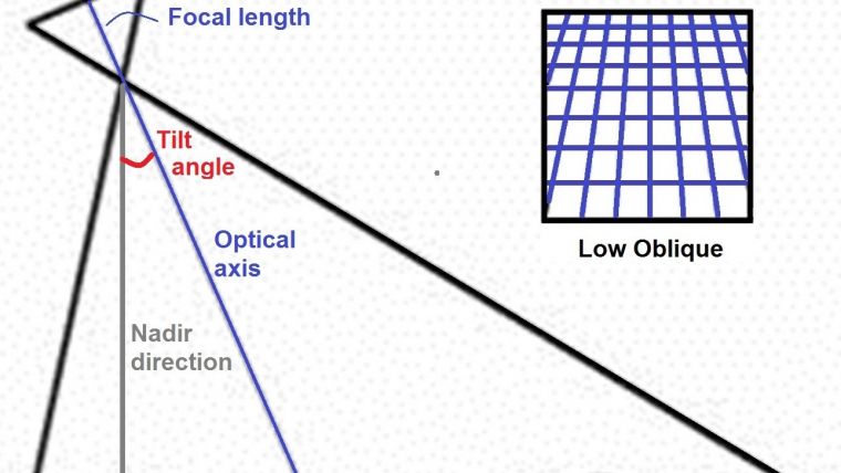
Most of the 3D city models and digital maps in car navigation systems or route planners originate from aerial or spaceborne imagery as their source. The images have been captured by high-definition cameras which are manufactured by a dozen or so firms. Starting around 1990, R&D efforts were focused on the move from film to digital, leading to the rapid launch of digital (oblique) camera systems from 2000 onwards. Oblique images are taken such that the orientation of the optical axis deviates with intent from the vertical, i.e. nadir direction. If the horizon is visible, the image is called ‘high oblique’ or otherwise ‘low oblique’ (Figure 1). Oblique images are usually captured by multiple lens systems. These consists of two or more lenses mounted in the same camera body or two or more cameras mounted in an array so as to keep the angles between their optical axes fixed. The shutters are usually synchronised to obtain exposures at the same instant. The accuracy largely hinges on how well the optical axes can be calibrated and retained. A good description of the characteristics of oblique aerial images can be found in Pictometry’s patent (see below) and in my Endpoint column.
Configurations
There is nothing new about taking oblique images – they have already been in use for over a century for military survey and large-scale mapping projects. Around the year 1900, Scheimflug developed a multiple-lens camera viewing oblique in 8 directions. During World War 1, the US developed a tri-lens camera. In the interwar period, engineers employed by Sherman Fairchild extended this multiple lens system to the five-lens T3A, which remained the precision-mapping camera of the US Army until 1940. The T3A can be considered as the forerunner of today’s Maltese cross digital oblique cameras as it acquired five negatives sized 5.5 by 6 inches simultaneously (Figure 2). The central lens pointed vertically, i.e. in nadir direction, and the other four, which were spaced at 90 degrees intervals around the central lens, were tilted 43 degrees away from the vertical. During a mapping conference held in Washington in 1940, the military use of the T3A was abandoned in favour of the tri-metrogon, a cluster of three K-17 wide-angle reconnaissance cameras; one pointing in the vertical and the other two at a tilt angle of 60 degrees on each side to provide horizon-to-horizon coverage. The digital variant of the tri-camera configuration has also become popular in recent years. Figure 3 shows the so-called Fan configuration when one camera is looking into the nadir, the second to the left and the third to the right. In general, the Fan consists of two or more digital cameras which have been assembled such that their optical axes are in the same vertical plane, but each camera views at a different angle resulting in a panoramic view across track. Multiple camera heads can also be mounted in a block such that they allow extensive ground coverage – equal in all directions – during one exposure. Another method to obtain oblique views is by sweeping one or more cameras across track. The scan motion allows a large field of view across the flight direction and provides oblique views. Vision Map’s A3 dual-camera system operates according to this sweeping principle.
Pictometry
The first company to revitalise the Maltese cross concept in the digital era was Pictometry with its PentaView capture system. However, Chris Barrow – who has been CEO of EagleView, the parent company of Pictometry Int. Corp, since 2008 – stated in an interview in the March 2014 edition of GIM International that the PentaView capture system is not precisely a Maltese cross configuration like the Fairchild system, since the cameras have a higher oblique angle resulting in five distinct image captures as opposed to the single Maltese cross appearance on the ground. Pictometry, headquartered in Rochester, New York, USA, employs the PentaView system mainly for visual inspection purposes aimed at public safety and planning. In 1993 the company was awarded a patent on a cluster of five medium-format digital cameras on a mount and production started five years later. Each CCD of the five cameras of the patented system consists of 4,900 by 3,200 pixels and each pixel has a size of 9 micron and a radiometric resolution (RR) of 12 bit. The chips capture colour (RGB) images. Part of the system is a display and measurement software package called Electronic Field Study (EFS). Measuring length, height and area depends on the use of an accurate DEM. Pictometry got a strong boost in September 2005 when Blom Group entered into an exclusive licensing agreement with the company for 23 European countries to capture cities with a population of 50,000 or more.
Leica RCD30
The Leica RCD30 Oblique camera system, introduced in 2011, is available in two configurations: trio and penta. The trio configuration consists of one nadir camera with a focal length (f) of 50mm and two oblique cameras (f = 80mm), one forward-looking and the other viewing backward; the tilt angle of both cameras is 45 degrees. The penta configuration consists of 5 cameras arranged in the form of a Maltese cross; f is 50mm for nadir and 80mm for oblique and the tilt angle of the 4 oblique cameras is 35 degrees. The 80MP CCD contains 10,320 by 7,752 pixels of size 5.2 micron and the RR is 14 bit. The spectral range for all 5 camera heads is either RGB or multispectral, i.e. RGB plus near infrared (NIR: 780-880nm). The weight of the system including camera heads, controller, mount and integrated GNSS / IMU is 30kg. The trio configuration is aimed at 3D corridor mapping while the penta is suited for 3D urban mapping in particular.
UltraCam Osprey
Microsoft has given its product line of third-generation UltraCam aerial cameras the names of birds of prey: Hawk, Falcon, Eagle and Osprey. The latter is a nadir / oblique system, introduced in spring 2013, of which the cameras are arranged in a Maltese cross (Figure 4). The nadir camera is the same as the UltraCam Hawk, a 90MP mapping camera introduced in 2013. The nadir camera (f = 51mm) collects five bands: PAN, RGB and NIR. The image size of the PAN band is 11,674 by 7,514 pixels; each pixel has a size of 6.0 micron, resulting in a CCD format of 70.04mm by 45.08mm. At a flying height of 850m, the GSD is 10cm. The oblique cameras are tilted by 45 degrees, have a focal length of 80mm and a pixel size of 5.2 micron. The across track pointing cameras contain CCDs consisting of 6,870 by 4,520 pixels while the forward and backward cameras each contain two such CCDs, paired along the short edge (4,520 pixels) of the CCD, resulting in a stitched image of 13,450 by 4,520 pixels.
Trimble AOS
The Maltese cross coverage can also be realised by just three cameras, one pointing nadir and the other two viewing oblique. One such system is the Aerial Oblique System (AOS) initially constructed by RolleiMetric for Alpha Luftbild, a German aerial survey company, but now part of the Trimble stable. AOS comprises three Rollei AIC medium-format digital camera units, each of which is equipped with a 39MP CCD which consists of 7,228 by 5,428 pixels each having a size of 6.8 micron. The shutters of the three cameras are synchronised to simultaneously capture the vertical image and the two oblique images pointing in opposite directions across track. The complete three-camera unit can then be rotated rapidly by 90 degrees to obtain the second pair of oblique images pointing in the along-track direction. The three-camera unit can be lowered down through the port in the aircraft floor to operate outside the aircraft, and can be retracted when it is not in operation and during take-off and landing. RR is16 bit per colour and the focal length is 47mm. In combination with the CCD size of 49.1 mm by 36.9 mm, this results in a field of view of 55 by 41 degrees.
Midas
Large and medium-format metric cameras are often too expensive for projects which do not require high accuracy. A flexible solution is to mount small and medium-format cameras in an array in varying layouts. This is what Track'Air, founded in The Netherlands, did. They provide customised layouts consisting of an assembly of one to ten off-the-shelf RGB cameras, Lidar or multispectral sensors. The sensor packages include three cameras viewing nadir, forward and backward, or five cameras arranged in a Maltese cross of which the oblique cameras are tilted 45 degrees with respect to nadir (Figure 5). When introduced as Midas (Multi-camera Integrated Digital Acquisition System) in 2006, the system consisted of Canon EOS 1Ds Mk2 cameras equipped with Zeiss lenses, focused to infinity and focal lengths of 28mm or 50mm. The CCD size is 5,616 by 3,744 pixels and the size of each pixel is 6.4 micron. The current Midas model uses either the Canon 1Ds Mk3 or Nikon D800e cameras (7,360 by 4,912 pixels). The Zeiss lenses are focused to infinity and the focal lengths range from 50mm to 135mm. In March 2014, eight years after the launch of MIDAS of which over 100 systems have been supplied to customers all around the world, the Chimera consisting of five PhaseOne iXA cameras (size of the chip: 7,752 by 10,320 pixels and a pixel size of 5.2 micron) was presented at the 2014 ASPRS conference. The Schneider lenses are focused to infinity and one may choose from a range of focal lengths, including: 28mm, 55mm, 80mm, 110mm, 150mm and 240mm. At a height of 1.5km, GSD is 5cm.
Modular
The arrangement of individual small or medium-format cameras in a mount ensures multiple patterns which may be configured according to customer needs. Denmark-based COWI, for example, operates oblique camera systems based on the Midas concept. The types of camera have been adjusted to customer needs so that the nadir-looking camera is a Hasselblad with a Phase One back piece. The Phase One medium-format cameras are increasingly being assembled in arrays to configure oblique camera systems. Phase One is headquartered in Denmark too, and in mid-February 2014 it was announced that UK-based private equity firm Silverfleet Capital would acquire a 60% majority stake in the company. Phase One specialises in high-end digital photography equipment and software. Since 2012 the company has been extending its consumer base, which primarily consisted of professional photographers, to aerial photography by offering the iXA which has no viewfinder and very few mechanical moving parts. Since early spring 2014 the aerial survey market has been further served by the introduction of a lightweight medium-format camera: the iXU 150. The sensor, sized 43.8mm by 32.9mm, contains 8,280 by 6,208 pixels with a pixel size of 5.3 micron. ‘Lightweight’ has been the leitmotiv during the design as the camera body weighs just 750 grams (1.25kg with an 80mm lens). The weight reduction has been enabled through a magnesium chassis which is more expensive but is 30% lighter than the use of conventional materials. Figure 6 shows the camera and depicts the dimensions of the camera body.
Concluding Remarks
Part 2 of this diptych on oblique aerial camera systems will cover the oblique aerial camera systems of Digicam, Dimac, Icaros, VisionMap and Wehrli. If a camera system is not highlighted in this survey but should be, please feel free to contact me.
Acknowledgements
Thanks are due to all listed manufacturers of oblique digital aerial cameras for their feedback on the final draft.
Pictometry: selected quotes from patent US 20040105090
Conventional photogrammetry involves the capture and / or acquisition of orthogonal images… although orthogonal and ortho-rectified images are useful in photogrammetry, they lack information as to the height of features depicted therein and require highly-trained analysts… Oblique images are considered to be of little or no use in photogrammetry. To […] warp the image onto a coordinate system dramatically distorts the oblique image and thereby renders identification of objects and the taking of measurements. Correcting for terrain displacement within an oblique image by using an elevation model further distorts the images thereby increasing the difficulty with which measurements can be made and reducing the accuracy of any such measurements. The present invention comprises … a computerised system for displaying, geolocating, and taking measurements from captured oblique images. Image display and analysis software is executed by the system… The software retrieves the positional data for one or more user-selected points on the displayed image, and calculates a separation distance between any two or more selected points. The separation distance calculation is user-selectable to determine various parameters including linear distance between, area encompassed within, relative elevation of, and height difference between selected points. Oblique images, unlike orthogonal images, display the sides of terrestrial features, such as houses, buildings and/or mountains, as well as the tops thereof. Thus, viewing an oblique image is more natural and intuitive than viewing an orthogonal or ortho-rectified image, and even casual observers are able to recognise and interpret terrestrial features and other objects… Oblique images capture a generally trapezoidal area or view of the subject surface or object, with the foreground of the trapezoid having a substantially smaller ground sample distance (i.e., a higher resolution) than the background of the trapezoid.
Biography of the Author
Mathias Lemmens gained a PhD degree from Delft University of Technology, The Netherlands, where he presently lectures on geodata acquisition technologies and geodata quality on a part-time basis within the recently renewed MSc in Geomatics programme. He is the author of the book Geo-information: Technologies, Applications and the Environment published by Springer in 2011. He was editor-in-chief of GIM International for ten years and now contributes as senior editor.
Email: m.j.p.m.lemmens@tudelft.nl
Figure Captions
Figure 1, Low oblique view. Inset: the scale becomes gradually smaller from bottom to top of the image, that is from foreground to background in the scene.
Figure 2, Maltese cross concept: principle (left) and a rectified mosaic of Fairchild T3A images.
Figure 3, Fan concept using a three-camera arrangement.
Figure 4, View of the UltraCam Osprey clearly showing the nadir and oblique-looking heads.
Figure 5, Midas: mounting of individual medium-format cameras to a Maltese cross configuration.
Figure 6, Phase One iUX 150 and the camera body dimensions.

Value staying current with geomatics?
Stay on the map with our expertly curated newsletters.
We provide educational insights, industry updates, and inspiring stories to help you learn, grow, and reach your full potential in your field. Don't miss out - subscribe today and ensure you're always informed, educated, and inspired.
Choose your newsletter(s)


