
Earth Observation Data and Image Processing for High-level Humanitarian Support
An Efficient Approach for Estimating Refugee Camp Populations
The combination of high-resolution satellite Earth observation data and image processing software provides an efficient approach for estimating populations of refugee camps.
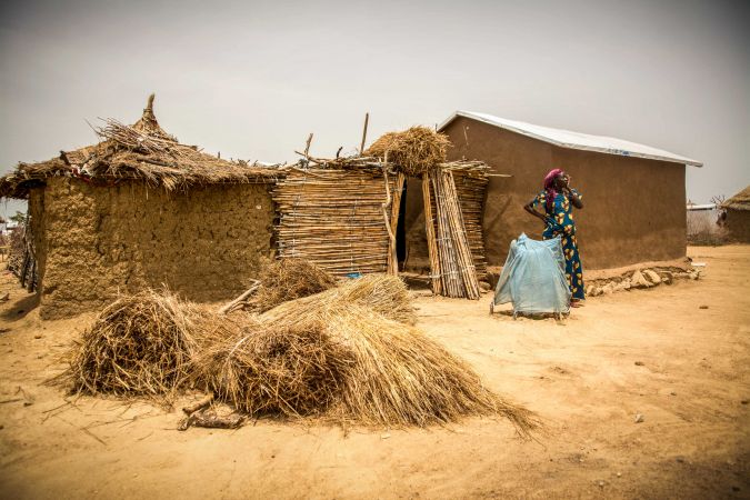
Over the past decade, the world has witnessed a steady increase in the number of people forced away from their homes by natural disasters or political unrest. They often end up in camps that hold tens of thousands of refugees. The camps are supported by non-governmental organisations (NGOs) that provide food, shelter and medical assistance. To manage their operations, NGOs and other agencies need to know how many people are in a given camp. This article explains how a combination of high-resolution satellite Earth observation data and image processing software provides an efficient approach for estimating camp populations.
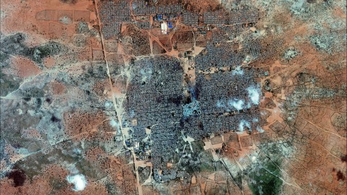
The refugee population is growing rapidly. Recent estimates from the United Nations indicate that nearly 68 million people fled their homes in 2016, up from 64 million in the previous year. Often located near war zones, the largest camps hold more than 200,000 people. When essential services such as food, clean water and sanitation are in short supply, malnutrition and sickness can take hold. Financial and material support is limited, though, and a camp’s infrastructure is often overtaxed. Because of their limited funding, NGOs have become adept at planning and resource allocation. Information on population size and trends for a given camp helps the NGOs to optimise the return on their spending. Producing good data, however, is not easy. Aircraft – including unmanned aerial vehicles (UAVs or ‘drones’) – and satellites can capture aerial images of the camps, but manually extracting reliable population data from these photos can be painfully slow and expensive. Médecins Sans Frontières (MSF), an NGO supporting refugee camps, teamed up with experts at the University of Salzburg’s Department of Geoinformatics (Z_GIS) to find a solution. Z_GIS conducts research into the use of satellite imagery with advanced image processing techniques to monitor populations. One of its key objectives is developing automated approaches to extract population information from satellite images of refugee camps.
Accurate Counts
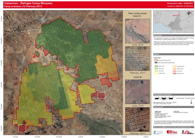
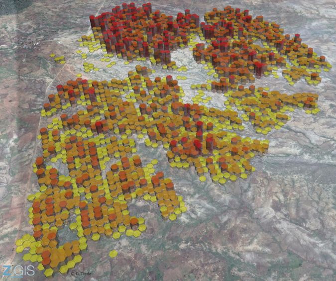
To measure the populations, Z_GIS obtains very-high-resolution (VHR) imagery (less than 1 metre per pixel) from commercial suppliers such as DigitalGlobe and Airbus (Pleiades). The images are processed using Trimble’s eCognition software to produce estimates on the number of physical dwelling units in a camp. The results can be displayed using tools such as ArcGIS or Google Earth to provide geographic context. Teams can then add ground data about the average number of residents per dwelling, enabling them to estimate the size and distribution of the population. The process can be repeated to quantify population change and movement within a camp. The ability to repeat the population analysis quickly is important, since rapid changes can occur in a camp during a crisis.
Rule Sets
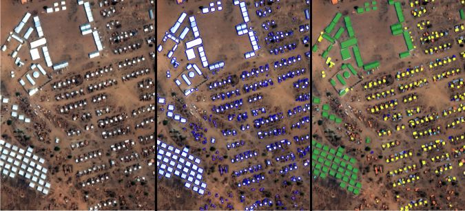
Object-based image analysis (OBIA), a method available in eCognition, is used to identify and classify features in an image. According to Dr Dirk Tiede of Z_GIS, OBIA offers greater flexibility and efficiency than pixel-based analysis techniques. Tiede develops customised processes (known as ‘rule sets’) that effectively train eCognition to recognise and classify individual features within an image. The objective is to identify man-made structures and to differentiate dwellings from other camp buildings such as food stations and medical facilities.
The rule sets use edge detection algorithms to delineate camp margins and to classify man-made features. Spatial characteristics of different dwelling types, along with relative spectral differences between objects, enable the rule sets to distinguish light-coloured dwelling structures from darker buildings and fences. The system determines the spectral values in order to separate dwelling types as well as areas with and without vegetation. The comparison is based on specific spectral ranges or vegetation indices such as the Normalised Difference Vegetation Index (NDVI). These values are saved as variables within the rule set and can be combined with other independent spectral parameters. Once a rule set is constructed, it can be transferred and adapted to work in different camps, or at different times in the same camp when the environment has changed.
Hybrid Approach
The initial rule set was developed using archived QuickBird imagery of the Zam Zam camp in Darfur, Sudan. To test transferability, the rule set was applied to a series of QuickBird images taken in the years prior to and following the original dataset. Additional tests used GeoEye-1 imagery at camps in Darfur. During these tests, Z_GIS found that the primary challenges came from varying vegetation at new sites as well as differences in characteristics of various satellite sensors.
Complex situations occur when camps show a very diverse set of structures or several development phases. In addition, local conditions may change the appearance of structures over time. For example, in some camps brightly coloured tents are used, which are relatively easily recognisable. However, when a sandstorm passes over and covers everything in a brownish dust, the given rule set may need to be adapted quickly. Therefore, a hybrid approach was applied that combines the automated solution with manual image interpretation for analysis and quality checking. The tests performed by Z_GIS showed that the rule sets could be adapted successfully using visual inspection on the computer screen and redefining appropriate spectral thresholds for structures and the NVDI for vegetation.
Population Dynamics
Effective population monitoring relies on rapid acquisition and processing of satellite data. Once imagery is acquired, the main bottleneck occurs in image processing. Using more efficient algorithms and faster computing technology (including the distributed computing ability of eCognition Server), it is possible to analyse an entire VHR satellite scene in just a few minutes.
To further reduce the time and staffing level required for analysis, Tiede and his colleagues are working to improve workflows around the automated processes. They are developing applications and solutions with the goal of producing initial data for a camp very quickly. From there, the team can build on the results to produce temporal information on population dynamics.
New Applications
Satellite imagery supports NGOs in more than just population estimates. For example, organisations want to avoid the expensive and risky practice of trucking water to the camps. Using lower-resolution imagery from Sentinel or Landsat satellites, Z_GIS can develop an overview map of a camp’s geohydrological situation to identify possible well sites. Natural disaster aid efforts also benefit from satellite imagery in analysing the extent and nature of damage for first responders and longer-term recovery. After the devastating 2010 earthquake in Haiti, Z_GIS produced a damage map within two days of the event. In emergency situations, the turnaround time is critical. The urgency is usually not as great for refugee camps, but timeliness does matter for highly dynamic situations such as the Rohingya crisis in Bangladesh.
The humanitarian team at Z_GIS continues to work closely with MSF and other NGOs, including the Red Cross movement, SOS Children’s Villages and Action Against Hunger.
Their work has produced a stable, operational service to support humanitarian organisations. It is an illustrative example of the value of Earth observation and image analysis in humanitarian aid. Natural disasters and other crises will continue. Putting advanced tools in the hands of dedicated specialists helps to provide better and faster relief to those in need.

Value staying current with geomatics?
Stay on the map with our expertly curated newsletters.
We provide educational insights, industry updates, and inspiring stories to help you learn, grow, and reach your full potential in your field. Don't miss out - subscribe today and ensure you're always informed, educated, and inspired.
Choose your newsletter(s)


