Enabling UAV-based 3D Mapping
Pix4D
Pix4D has developed next-generation software that automatically combines raw images captured by lightweight Unmanned Aerial Vehicles (UAVs) to produce accurate measurements and visualisation of the environment. This enables timely, on-demand local 3D mapping.
What if images taken by consumer-grade cameras could be combined to compute accurate 3D environments? This is the question that prompted Dr Christoph Strecha’s research 10 years ago. Back then, the first megapixel cameras were just starting to appear on the consumer market. Christoph’s research led to the development of techniques to produce 3D reconstructions in a fully automated way from a set of standard digital images. These results were published at the leading computer vision and photogrammetry conferences.
Since then, consumer cameras have drastically improved, packing millions of pixels into ever-smaller and lighter bodies. Memory soon stopped being a limitation, and the world was flooded with gigabytes of digital images. In order to make sense of all of this data, Christoph and his team invented techniques to process these thousands of images together, allowing new applications such as the recreation of virtual 3D cities from a collection of images gathered from the internet. In addition, a very important step was achieved in 2008 by showing that these techniques could rival Lidar solutions in terms of accuracy, obtaining millimetre accuracy at a few metres’ distance.
In parallel, lightweight flying platforms such as UAVs became affordable and easy to use, thanks to the advances in their embedded autopilots. There are currently hundreds of UAV manufacturers around the world, and legislation is progressively gearing up for worldwide usage. Weighing between 500g and 2kg, micro UAVs are particularly safe. Due to their limited payload, they are usually equipped with consumer-grade point-and-shoot cameras and are now principally used for aerial photography.
Christoph founded Pix4D in 2011 with the goal of enabling and increasing the availability of timely, easily updatable high-quality 3D geospatial data. The addition of the time dimension is reflected in the company’s name. UAVs provide a flexible way of capturing a nearly infinite flow of aerial images: Pix4D automatically turns them into accurate, professional 2D maps (orthomosaics) and 3D models (digital elevation models).
Pix4D Today
Having started as a spin-off of the prestigious EPFL (Ecole Polytechnique Fédérale de Lausanne) in Switzerland, Pix4D is now a dynamic and rapidly expanding company. It enjoys strong venture capital backing, and aims to have 15 employees by the end of this year, growing to 30 by the end of next year. Pix4D is pursuing its R&D efforts by collaborating with EPFL’s computer vision lab as well as other industrial partners in research projects supported by the Swiss government.
Pix4D products currently include a cloud-computing service as well as standalone desktop software: Pix4UAV. Furthermore, the company provides OEM-based solutions dedicated to particular professional UAVs, such as Gatewing’s Stretchout, Stretchout Cloud and senseFly’s Postflight service and Terra 3D that are all powered by Pix4D. However, Pix4UAV is not limited into specific UAVs and works with any flying platform and any camera equipped with a standard GPS receiver. Pix4D’s clients are using over 20 types of UAVs in the shape of helicopters, fixed wings, balloons and kites that are equipped from standard point-and-shoot cameras to professional thermal and infrared sensors.
Enabling a new generation of surveying tools
Pix4D presents a paradigm shift with regards to traditional photogrammetry. Instead of relying on extremely precise hardware that requires heavy airborne solutions, it takes advantage of the huge amount of data provided by standard cameras mounted on UAVs and affordable computing power to generate accurate measurements. This enables surveyors and geometers to easily and quickly generate on-demand 2D and 3D maps of the environment on their own.
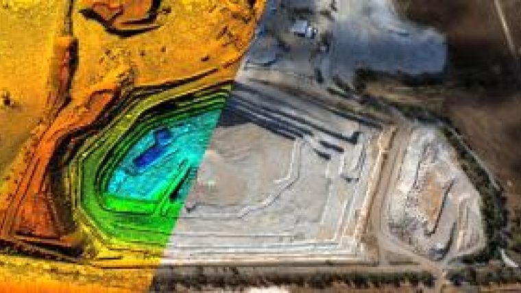
Pix4D’s primary market currently consists of surveyors working for the mining industry. As mining tools are becoming increasingly automated, this industry has an ever-growing demand for 3D maps. Ground-based surveys can take several days and limit operations, while airborne-based surveys are prohibitive for logistics and cost reasons. With the current generation of automated UAVs, no flight knowledge is required and the image acquisition is done within an hour for areas of up to 10 square kilometres. Depending on the flight elevation and the onboard camera, clients report an accuracy ranging from 5 to 15 centimetres, numbers that have been validated at international scientific conferences (UAV-g, ISPRS). Volumetric comparisons with respect to Lidar on mining sites have shown differences of less than 1%.
Pix4D’s solution is already used for many other applications worldwide, such as pipeline inspection, road construction surveys, precision farming and urban areas modelling among others. The International Organization for Migration (IOM) and UNOSAT embarked on their very first UAV mission in February and officially validated Pix4D’s solution in direct support of ongoing earthquake recovery projects in Haiti. It provided highly detailed maps of the camps and was key in detecting and relocating settlements exposed to flood risks.
The Future of UAV Mapping
Technical progress in computing power and software has shown that heavy and expensive sensors are no longer required to produce high-quality data, thus opening the door for UAV mapping. The professional industry acknowledges this, as illustrated by the recent acquisition of the UAV manufacturer Gatewing by Trimble. Pix4D foresees that the huge demand for this new solution will lead to mass production of even lighter, easier to use and affordable UAVs. Furthermore, the company imagines a future in which UAVs will no longer require human operators for launching and landing, and in which they will survey a particular area at regular time intervals, transmitting the captured data automatically. Pix4D is continually working to develop and improve its current solution to make flexible, continuous, real-time surveys and 3D mapping a reality.

Value staying current with geomatics?
Stay on the map with our expertly curated newsletters.
We provide educational insights, industry updates, and inspiring stories to help you learn, grow, and reach your full potential in your field. Don't miss out - subscribe today and ensure you're always informed, educated, and inspired.
Choose your newsletter(s)


