Establishing an accurate geodetic reference network for Uganda
Facilitating cadastral surveys, city developments and road construction
In line with the United Nations resolution to adopt a global geodetic reference network, the Government of Uganda received financing from the World Bank towards the cost of a competitiveness and enterprise development project. As part of this, Fugro was commissioned to design and implement a modern, reliable and accurate national geodetic reference network for the whole country, in addition to the deployment of a national continuously operating reference station (CORS) network.
Effective management of land resources is of vital importance to the Government of Uganda in order to support the country’s development and reduce poverty. The improvement of the land administration system, directly linked to developing the agriculture, mining and construction sectors in Uganda, is one of the country’s priorities. However, like many African countries, Uganda faces challenges in establishing the institutional and legal framework necessary for ‘good land administration’ and, consequently, lacks accurate and reliable land information, including up-to-date cadastral and topographic maps and orthorectified imagery.
Transformation
The transformation of the land sector and the development of the Land Information System demonstrated a critical need for a modern geodetic network for improved reliability and accuracy of land registration information and services. Back in the 1960s, a horizontal geodetic control network was completed in Uganda using the triangulation method. It was referenced to the 1960 Arc datum and the Clarke 1880 ellipsoid, and comprised 1,730 geodetic control points and a levelling network consisting of 3,033 benchmarks (1972), all referenced to the New Khartoum vertical datum.
Over the following decades, most of the trigonometry points and levelling benchmarks were destroyed. Several independent updating campaigns created a complex database expressed in different datums and different epochs, resulting in a land administration system that was highly inaccurate and in desperate need of updating. A new system and network called the Uganda Geodetic Reference Network (UGRN), commissioned by the Government of Uganda, promised to be a game-changer for land surveyors from Uganda’s public and private sectors because it would provide a rich new seam of reliable, accurate and easily accessible data to inform their land administration and land use planning work. The data would also be used for spatial data activities in construction and other economic sectors and for environmental protection work.
Phase 1: Network design and reconnaissance
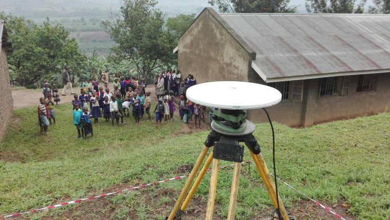
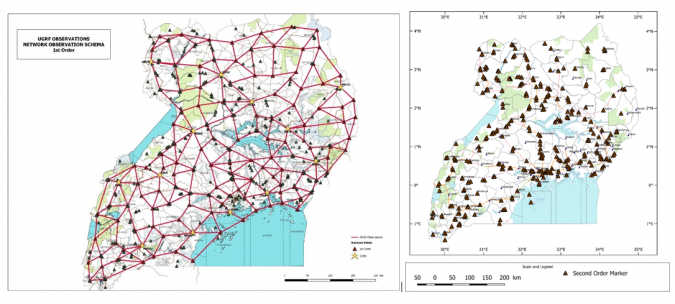
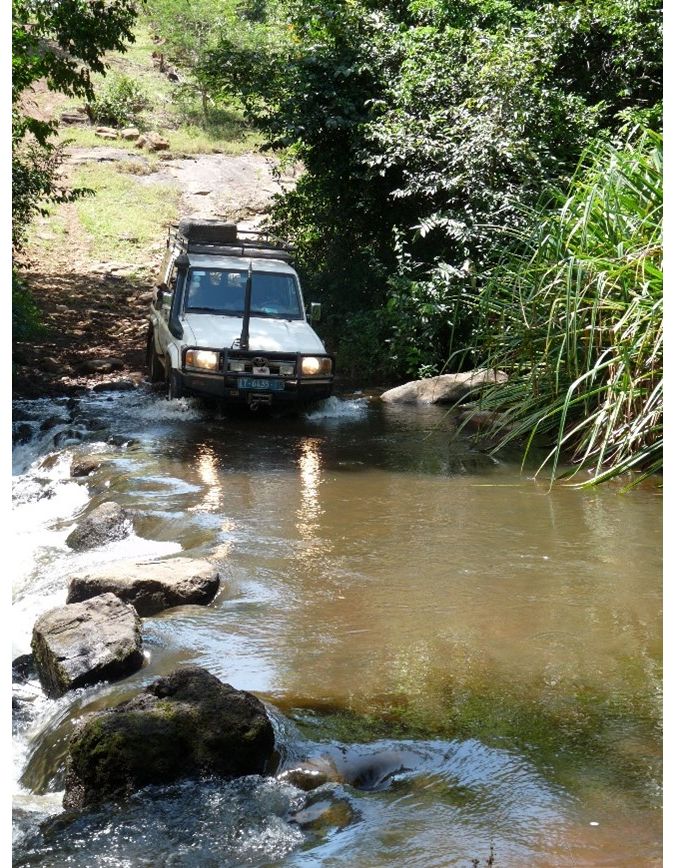
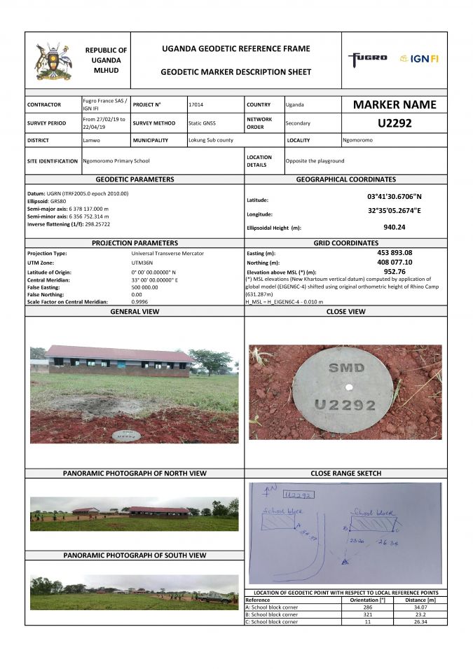
Fugro’s 18-month project to update and implement the UGRN began in June 2017 with three months of fieldwork. During this initial phase, conditions were often challenging, typified by badly maintained roads, difficult terrain and poor access to remote areas and islands. The work involved reconnaissance fieldwork inspecting the existing trigonometry points and levelling benchmarks, plus a countrywide search for suitable sites for the new geodetic points. Of the 426 new and 106 existing network sites, only 50% were considered usable for datum transformation parameters computation.
To obtain community buy-in, control costs and ensure the longevity of the new system and network, the fieldwork was carried out by three Ugandan teams who were recruited, trained and supervised by an on-site Fugro expert. Occasionally, the team encountered resistance among local community members who could not see the long-term national economic benefits of the proposed work. To address this, Fugro employed four highly competent Ugandan sociologists who understood the social context and were on hand to intervene whenever required during the first three phases of the project.
For the field operations, Fugro developed a dedicated smartphone application to monitor the teams’ progression. This application – optimized to cope with the challenging environment and poor communications network – supported health and safety and facilitated near real-time quality assurance and control. It proved more efficient, cost-effective and consistent than traditional paper-based methods and the local technicians became enthusiastic adopters of the new technology.
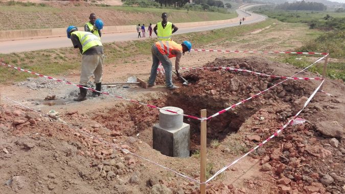
Phase 2: Monumentation of geodetic benchmarks
Phase 2 is typically underestimated when establishing geodetic networks, but it is generally the riskiest – not only for financial reasons due to the workforce and logistics involved, but also in terms of guaranteeing the quality and sustainability of the network. To reduce operational risk, Fugro selected several local organizations to carry out the monumentation of 426 geodetic markers during a six-month period. The work involved 45 people who, before starting monumentation, were provided with a detailed scope of work, methodology and rigorous training by an on-site Fugro expert. After a few weeks, the monumentation teams were managed remotely by the Fugro project team, based in France, using the online smartphone application.
Phase 3: GNSS observations
The GNSS observations took 50 field days and involved up to 42 workers with 426 new points (129 first-order markers and 297 second-order markers), 60 existing points and 993 baselines. Thanks to efficient preparation, real-time QA/QC and the dedication of all team members, resurveying took only two days, equivalent to just 4% of the total observation time. This result is particularly impressive given that there were 13 teams working in different locations throughout Uganda, and the observation constraint for all GNSS receivers to record data simultaneously.
A key part of this success was the selection and training of the Ugandan staff. The surveyors received two days of intensive training, which included health, safety, security & environment (HSSE) instructions, observation strategies, GNSS equipment methodology and the use of Fugro’s smartphone application to communicate, navigate and complete the field numerical observation form. The field teams involved surveyors from the National Survey Department and three private land survey companies. This allowed knowledge sharing between Fugro and Ugandan surveyors’ communities throughout the project.
Phase 4: Computation and adjustment
For the final phase of the project, which took three months to complete, Fugro integrated additional GNSS observations from the newly built network of 12 continuously operating reference stations (CORS) using a dual-processing strategy; for the CORS network, calculations were performed in parallel with Bernese and Gamit-Globk software and demonstrated a high level of consistency. The first-order and second-order networks were mainly computed using ‘imbricated orders’ methods, where each higher-order network is computed using the least square adjustments constrained to its lower-order network. This is controlled and validated by a ‘full Bernese’ approach involving the simultaneous processing and adjustment of all observations from zero to second order and constraining the global result to CORS network coordinates. The accuracy at 95% level of confidence is estimated at 1cm in horizontal and 2cm in vertical for the first order and 1cm in horizontal and 3cm in vertical for the second order.

The scope of work involved computing the transformation parameters between the UGRN and the historical triangulation network. To achieve this, Fugro used trigonometry points that were recovered and observed during the project to derive all possible types of geodetic transformations between reference and historical geodetic datums.
To make best use of the GNSS CORS network for non-cadastral applications, such as development of the country’s civil engineering infrastructure, it was necessary to define an interim geoid model consistent with the vertical datums currently in use in Uganda. Contrary to the traditional approach, which consists of simply adjusting existing levelling benchmarks to EGM08 (the widely used global geoid model), Fugro used and slightly improved (using the residual Terrain Model) the EIGEN-6C4 global gravity model, best-fitted to levelling benchmarks that were recovered and observed during the project. As well as the standard longitude and latitude information, Fugro’s interim geoid model provides reliable height information from anywhere in Uganda. It is faster, cheaper and more accurate than traditional methods. However, the lack of gravity data across the country and existing levelling benchmarks mean that further field campaigns are necessary if Uganda is to have a state-of-the-art geoid model in the future.
Traditional geodesy and a new way of working
Establishing the UGRN was a huge and complicated undertaking that spanned the length and breadth of Uganda. Fugro delivered training at different stages of the project to help local technicians and surveyors derive maximum benefit from their involvement and increase their knowledge about the different products. This project was a perfect blend of traditional geodesy in challenging remote places and a new way of working. Advanced technologies for were used for field operations (smartphone application and direct payment of local surveyors) and processing (scientific software and cloud-based communication and computing) combined with stringent HSSE procedures to prevent any incidents.
The UGRN is a long-term, homogeneous, accurate and easy-to-use solution accessed via a dedicated website that allows local survey practitioners to perform complementary surveying work without the need for local adjustments. This approach is designed to maintain a high level of consistency in planimetry and height for Ugandan projects going forward, such as cadastral surveys, city developments and road construction.

Value staying current with geomatics?
Stay on the map with our expertly curated newsletters.
We provide educational insights, industry updates, and inspiring stories to help you learn, grow, and reach your full potential in your field. Don't miss out - subscribe today and ensure you're always informed, educated, and inspired.
Choose your newsletter(s)


