Exploring the State of Mobile Mapping
Findings from an International Survey into Acceptance and Applications
What is the current state of acceptance of mobile mapping, and what are its most common applications? A worldwide survey commissioned by NavVis, and supported by 'GIM International' plus three other publications, was recently conducted to find out. Here, we highlight some of the key findings and share the reactions from a number of suppliers of mobile mapping products.
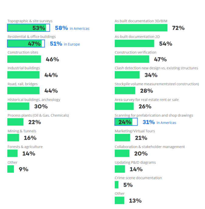
The NavVis survey into the State of Mobile Mapping 2021 was conducted among approximately 150 companies in over 20 countries. Most respondents were surveying or laser scanning experts working for specialist contractors. In terms of their customer base, the majority of respondents provide scanning and surveying services to a variety of external clients across a wide range of sectors. Clients in the architecture, engineering and construction (AEC) sector score the highest percentages and are currently the biggest users of mobile mapping services (Figure 1).
Working Environment and Applications
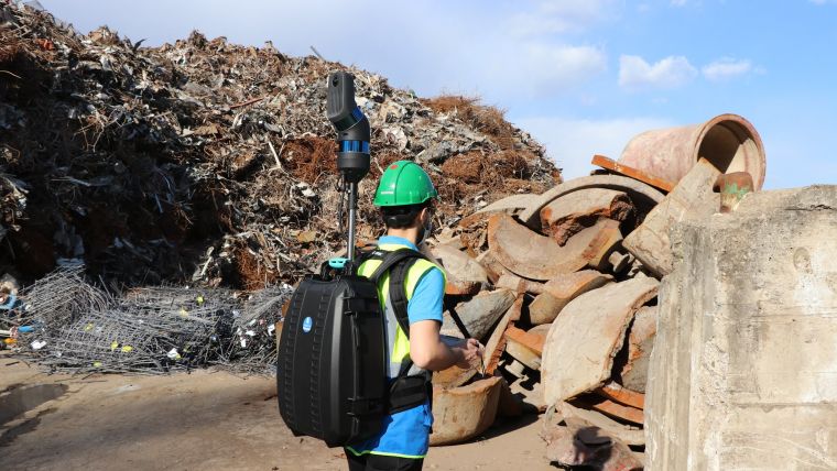
The most important working environments mentioned by the respondents are topographic
and site surveys (53%), residential and office buildings (47%), construction sites (46%), industrial
buildings (44%), and road, rail and bridges (44%). Many surveys are carried out inside buildings, where GNSS reception is poor. One benefit of mobile survey equipment is that it causes little disruption to operations; it can often be undertaken while work continues, or during breaks in production. Furthermore, many mobile mapping solutions have software features to remove elements such as people and vehicles in the scanned area.
Deliverables and Software
The most popular application of mobile mapping is to produce as-built documentation. The full range of deliverables includes point clouds, 3D/BIM models, imagery, survey reports and 2D floor plans. Construction verification and clash detection are also widely mentioned.
The respondents were also asked about the software they use. As expected, various AutoDesk applications are particularly popular. Bentley MicroStation also made it into the top five. Surveyors intending to use mobile mapping need to spend time with clients to determine their needs (accuracy, resolution, file formats, etc.), especially as clients may be unfamiliar with concepts such as point clouds. Often, a combination of 2D/3D plans, BIM and panoramic photographs will be needed. Most suppliers of mobile mapping solutions supply tools for this. Another option is to use software which imports data files from laser scanners of different makes, such as Gexcel Reconstructor. There is also software for hybrid workflows.
Current and Future Hardware Ownership
The survey provides interesting information about the current and planned use of hardware, including mobile mapping systems, total stations, terrestrial scanners, GNSS rovers and unmanned aerial vehicles (UAVs or drones), and all these hardware types are covered in more detail in the survey report.
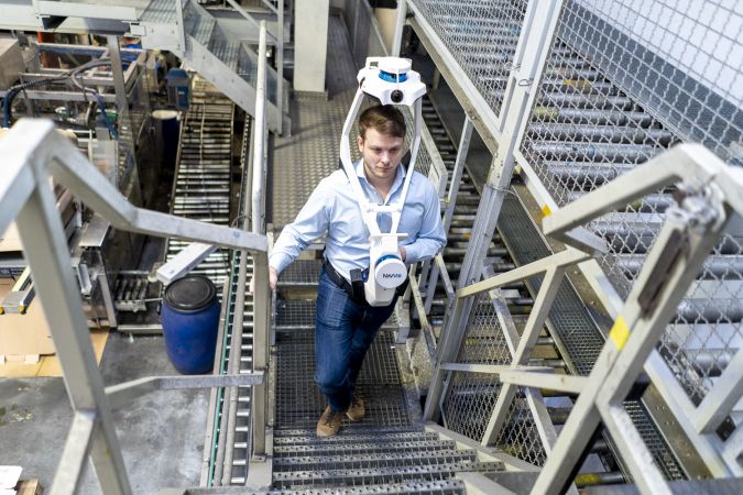
In terms of mobile mapping systems, 39% of respondents currently use a handheld system and 35% expected to invest in such a system in the next one or two years. Wearable systems are used by 28% of respondents, with 41% planning to acquire one within two years. When it comes to the preferred options for future investments, the NavVis VLX wearable mobile mapping device takes the lead (43%), followed by the handheld Leica BLK2Go (28%) and GeoSlam handheld products (26%). All these systems are user-friendly and can be used for a range of applications including as-built surveys and producing the digital twins which many customers are now looking for.
Among those respondents who are not currently using or planning to invest in mobile mapping systems, budget limitations are given as the main perceived barrier to adoption. Some respondents are concerned about the expense compared with the deliverables, the perceived lack of accuracy, and compatibility with existing workflows. Kathy Pattison of Kaarta comments, “Users do not like it when vendors only provide ‘walled gardens’ for processing and sharing their data. Open standards and flexibility of the use and sharing of data will be important across many sectors. We expect better integration of point clouds and large datasets into existing software tools. Vector or surface-based CAD will not always be the end result; we could live in the point cloud rather than doing many conversions.”

Making Life Easier
The reactions to a number of ‘agree/disagree’ statements in the survey indicate that a large majority of respondents expect mobile mapping to contribute significantly to construction quality, and to the internal workflows and growth of surveying businesses. Current and potential users of the mobile mapping systems are also keen to operate modern technology in order to maintain their competitive edge. Most respondents see significant potential for offering new services to their customers.
There are certainly opportunities for improved integration with data obtained by terrestrial mapping equipment and equipment mounted on drones and vehicles. “We expect to see integration of mobile mapping with other sensors – for example, combining SLAM-based systems with subsurface sensors (underground infrastructure, UXO), radiation sensors, chemical detection, thermal, etc.,” observes Kathy Pattison of Kaarta. Dr Stefan Hrabar, CEO and co-founder of Emesent agrees, commenting: “There are so many more areas where mobile mapping could be making life easier for those in the surveying industry. Combining mobile mapping with drone autonomy makes even more areas accessible, such as the underside of a bridge or an underground mine. Having a single unit which can be mounted on a backpack or a drone makes it possible to capture the inside and outside of a building with one unit, driving efficiencies for the customer. We also expect that the workflow will move towards a full digital model, for example the digitization of cities for civil planning or the digital mine.”
Industry Reactions to the Survey Findings
Zhaoxuan Li of GreenValley comments: “The results of the survey are in line with our perception of the market. The mobile mapping industry is still in the early stage of development. GreenValley International is taking extra steps towards paving the way for a smooth transition.” Charles Mackenzie of NavVis states: “We are very pleased with the results of this survey. It is good to see changed perceptions – a few years ago, most people thought mobile mapping was nice but not good enough for professional work. As a result of the advances, mobile mapping devices are now becoming part of a surveyor’s standard toolkit, sometimes combined with existing technology or other new technology such as drones.” Prof Giorgio Vassena, CEO of Gexcel, agrees, saying: “The mobile mapping approach, for indoors especially, opens up new business opportunities with respect to those covered until now by terrestrial laser scanners or standard surveying technologies.”
Conclusion
The survey shows that mobile mapping is already widely accepted and adopted in a number of markets, and many more respondents are planning to invest in the equipment in future. The barriers to entry will be reduced as the accuracy of equipment continues to improve and prices drop further. The resulting shorter payback period will make investments in equipment and the associated workflow more attractive. For some potential users, the current accuracy of mobile mapping equipment may already be already high enough. Greater familiarity with the strengths and weaknesses of mobile mapping equipment is also likely to lead to greater acceptance and more widespread use. There is clearly still great potential for growth of mobile mapping systems, both in established and new markets.
Key Survey Findings
- Mobile mapping equipment is already widely accepted. At the time of the survey, 28% of the respondents owned and operated a backpack mobile mapping system. This figure is predicted to rise to 51% within 12 months. Handheld systems are even more popular: currently at 39%, expected to rise to 60%.
- The top three requirements in a mobile mapping project are: 1) point cloud accuracy and high-quality imagery, 2) scanning speed and time spent on site, and 3) an integrated seamless software workflow from scanning to deliverables.
- Around 75% of respondents are confident that mobile mapping meets their accuracy requirements.
- A large majority of respondents envisaged a hybrid workflow, combining mobile mapping hardware with terrestrial scanners.
What is Mobile Mapping?
Mobile mapping is based on simultaneous localization and mapping (SLAM), developed in the 1980s for autonomous robots. The first vehicle-mounted systems were large and heavy. Portable or wearable systems are a more recent development, made possible by smaller and lighter sensors (Lidar scanners). For example, survey sponsor NavVis introduced its first system in 2015 and other suppliers entered the market in the same period.
Mobile mapping units use Lidar scanners to measure the distance between the unit and features in its environment. As the unit moves around in space, more and more data is captured and used to create a point cloud. While point clouds are valuable deliverables for surveying professionals, other specialists – such as architects and building services engineers – find them less easy to work with. Hence, mobile mapping solutions also incorporate cameras. The resulting deliverables are both geometrically accurate (point clouds from the laser scanners, where each point also has an RGB value) and easy to understand (panoramic photographs). Many systems can use control points to link the scans to conventional surveys.
The systems are generally supported by software suites which provide features such as:
- processing the point cloud
- interfacing with other software
- integration with data from terrestrial mapping (hybrid workflow)
- making the scans available in the cloud, accessed through a browser so the end-user does not need a powerful computer or a local copy of the full dataset.
Thanks to rapid advances in mobile mapping systems, the resolution and accuracy of the data is now sufficient for many surveying applications. The applications are hugely varied, not only in the construction industry, architecture, infrastructure and engineering, but also in search & rescue, video games and the film industry.
Mobile and Terrestrial Mapping Compared
One advantage of mobile systems is that the operator can walk around a site and even go up and down stairs while scanning. Mobile systems support the fast and efficient delivery of accurate results (generally to within 10mm) without disrupting on-site operations. Another advantage is that there is often just one dataset, avoiding the need to align multiple datasets. Terrestrial scanning provides similar deliverables. Although it can produce a higher accuracy, the process is slower as the scanner needs to be relocated regularly, and the datasets for each scanning location must be merged. Some projects therefore benefit from a hybrid approach of mobile and terrestrial scanning.
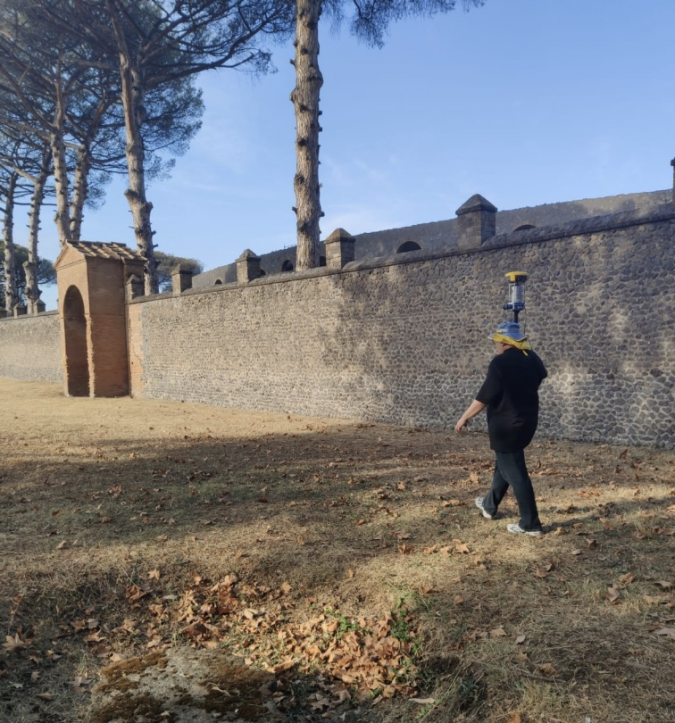
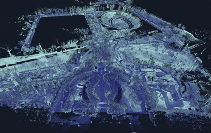
Mobile Mapping in Practice: Pompei Tree Survey
Besides being used to survey buildings and construction projects, mobile mapping systems have also been deployed in projects in underground mines, caves and – as this case illustrates – even for a tree survey at an important archaeological site in Italy.
When the city of Pompei was buried by ash and pumice from the eruption of the Mount Vesuvius volcano in 79 AD, many buildings and artefacts were preserved. A large part of the site has been excavated and it now receives around 2.5 million visitors every year. When some of the trees on the site became affected by disease, it was decided to undertake a comprehensive tree survey. This had to be done without inconveniencing visitors to the site and without the use of an unmanned aerial vehicle (UAV or drone). The route to be surveyed was around 13km long and included narrow passageways, stairwells, hallways, tunnels, valleys and overgrown areas. Conventional surveying would have been impractical and a test with a terrestrial scanner proved that this approach was too time-consuming. A test with a handheld scanner was also unsatisfactory due to various limitations associated with the unit and its software.
Paolo Mistrangelo from the company Magellano Progetti suggested the use of a Kaarta Stencil 2-32 mobile mapping system combined with a GeoMax Zenith 40 GNSS receiver. After tests showed this combination to be effective, the survey was conducted and the whole route was surveyed in just six hours. After post-processing, the final dataset amounted to 650GB and comprised 5.8 billion points, accurate to 3cm.
The data was then analysed to map over 3,000 trees and identify their size and species. This information enables the tree maintenance team to monitor the health of the trees and plan their work effectively.
https://www.kaarta.com/case-study/pompeii/
About the survey
The survey was developed by marketing specialists and industry experts, with input from four publications: Geo Week News, BIM+, Lidar News and GIM International. The survey targeted industry professionals, selected through the networks of the publications and the commissioning company. Around 150 responses were received, from over 20 countries. Most respondents were surveying or laser scanning experts working for specialist contractors. For the purposes of the survey and this article, ‘mobile mapping’ refers to mapping with laser scanners (Lidar), supplemented by cameras, carried by the operator or trolley-mounted. These units are also known as portable or wearable mapping systems. ‘Terrestrial mapping’ refers to the use of static units mounted on tripods.

Value staying current with geomatics?
Stay on the map with our expertly curated newsletters.
We provide educational insights, industry updates, and inspiring stories to help you learn, grow, and reach your full potential in your field. Don't miss out - subscribe today and ensure you're always informed, educated, and inspired.
Choose your newsletter(s)


