FIG Working Week 2013 in Abuja, Nigeria
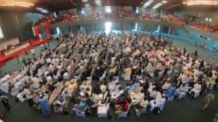
Under the theme ‘Environment for Sustainability’, the FIG Working Week was held in Abuja, Nigeria, in May 2013. The Working Week brought together participants from different cultures, diverse surveying traditions and varying professional experiences. The Working Week is the global forum for surveyors, practitioners, land professionals and FIG partners. There were in excess of 180 papers and presentations including peer-reviewed papers, academic, technical and practical papers and presentations from over 40 countries. It was a large event with more than 2,000 colleagues participating; attracting full attendance, the plenary sessions were a particularly impressive sight.
During his keynote, Hubert Ouedraogo (UN Economic Commission for Africa) highlighted the engagement of the community of surveyors in the implementation of the Land Policy Initiative (LPI). Surveyor contributions are in innovative/cost-effective land administration with evidence-based land policy processes and in documenting customary-based land rights. A win-win constellation for large-scale land-based investment needs attention. LPI is an initiative of the African Union Commission (AUC), Economic Commission (ECA) and the African Development Bank (AfDB). Remy Sietchiping, Global Land Tool Network (GLTN)/UN-Habitat, held a presentation on innovative tools and solutions to land challenges such as the Social Tenure Domain Model (STDM)/LADM, the gender evaluation criteria, land recordation systems, and decentralised land administration. GLTN/UN Habitat is promoting land re-adjustment in implementation of solutions in urbanisation and slums. Peter O. Adeniyi gave an overview of the developments in surveying, geodesy and land administration in Nigeria. Jide Kufoniyi fnis, former rector of RECTAS Nigeria, talked about capacity building. He sees very viable solutions in joint (cross-border) education. Jean du Plessis (UN Habitat) introduced the GLTN approach to capacity building: going beyond the technical aspect is key, as are partnerships. The expected accomplishment on capacity (2012-2015) is, “Strengthened capacity of partners, land actors and targeted countries, cities and municipalities to promote and implement appropriate land policies, tools and approaches that are pro-poor, gender appropriate, effective and sustainable”. Frank F. K. Byamugisha, World Bank, mentioned that documentation of all land is needed for security and for support to investors. Forced evictions should be avoided, object identification is relevant here – there is no need to see this as accurate boundary surveys, he said: “We need to act with a sense of urgency. We need to move away from surveying standards and technologies that are rigid to flexible ones to meet today’s needs while anticipating those of tomorrow. Relevance, and not accuracy, has to be our guiding principle. We have to balance accuracy with speed and cost when designing spatial frameworks. And we have to take advantage of opportunities offered by modern technology”.
Hussein Omar Farah, director general of the Regional Centre for Mapping of Resources for Development in Nigeria, gave a presentation on geoinformation for societal benefit. Peter C. Nwilo, surveyor general, Nigeria, presented the Nigerian adaption in technology. Peter O. Large, vice president of Trimble Navigation Ltd, presented a broad view of geospatial technology and systems. Today, he explained, land and airborne 3D high-precision mapping systems collect 4 billion data points per hour. Geospatial information has evolved from paper maps to GIS to 3D virtual models of the world, accessible to billions. GNSS infrastructure provides a unified framework for high-precision positioning in support of agriculture and forestry, civil engineering and infrastructure development (and BIM), transportation and logistics and development of cadastre and geospatial data infrastructure.
In addition to keynote plenary presentations, there were high-level segments and roundtables plus training-of-trainers workshops together with the FIG partners, notably UN-Habitat, Global Land Tool Network, the African Union Land Policy Initiative and the World Bank. The Joint UN-Habitat GLTN/FIG Surveyor Generals Roundtable/Director Generals Forum discussed LPI, the future for land professionals in Africa and the suite of pro-poor, gender-responsive GLTN land tools, tools to improve transparency in land administration, the land administration domain model and the social tenure domain model, and costing and financing of land administration services.
There was a lot of attention paid to application software and its relevance to surveying. For example, Brent Jones from ESRI presented on ‘Cadastre 2.0 – Leveraging New Technology for Efficient, Comprehensive Cadastral Systems’. There was also a focus on the FAO SOLA to provide additional software functionality required for systematic registration.
All the sessions were well attended and participants engaged in lively discussions – always with a smile. We’d like to say a big thank you to our fellow surveyors from Nigeria! It was great!

Value staying current with geomatics?
Stay on the map with our expertly curated newsletters.
We provide educational insights, industry updates, and inspiring stories to help you learn, grow, and reach your full potential in your field. Don't miss out - subscribe today and ensure you're always informed, educated, and inspired.
Choose your newsletter(s)


