From Barefoot to ‘Air-foot’ Surveyors
Building UAS Capacity for the Land Administration Sector
Unmanned aerial systems (UASs) have the potential to revolutionise land administration activities. The latest products are relatively inexpensive, automated, easy to use and are able to deliver the spatial accuracies and high-quality imagery required for the sporadic updates of cadastral boundaries. Consequently, there are opportunities for streamlined legal frameworks, new technical processes and improved organisational workflows. Seizing these opportunities will require substantial capacity development. Here the authors explore how UAS technology could have a significant and immediate impact on land administration activities in Sub-Saharan Africa, with specific focus on the experiences during a recent field demonstration in Rwanda.
As covered in the January 2015 edition of GIM International, land administration is changing. The historic, well-meaning conservatism inherent in conventional cadastral laws, administrative processes and technological applications is being superseded by the ‘fit-for-purpose’ mantra. In developing countries especially, the focus should be placed on approaches that are inclusive, participatory, affordable, reliable and scalable. New land policies developed over the last decade, particularly those from Sub-Saharan African countries, have driven this change in approach. Evidence from Rwanda, Ethiopia and Namibia already suggests that fit-for-purpose methods allow land administration systems to be established faster and at a lower cost.
UASs are an emerging part of the fit-for-purpose toolkit. Imagery capture can be undertaken locally (e.g. in areas of between 1 and 400ha) in an affordable and timely fashion. The results can be used to support flexible and participatory land-rights mapping or to upgrade previous mapping work. Studies by the World Bank demonstrate the application in Albania. Meanwhile, new research conducted by ITC (University of Twente, The Netherlands) in association with Micro Aerial Projects L.L.C. demonstrates the potential utility of UASs in both informal settlements and customary areas of Namibia.
However, as with many disruptive technologies, there are various potential barriers to adoption. First, legal restrictions relating to the use of UASs usually apply. Second, production workflows for adjudication and surveying activities may require redesign. Third, capacity needs to be developed within the surveying and para-surveying community with regards to flight planning, field expertise, processing and data analysis.
Technically Ready
As a geospatial technology, the UAS is reaching technical maturity and is already used in applications as diverse as topographic mapping, agriculture, construction, mining and emergency management. The land administration sector has been slower to recognise the opportunities offered by UASs (Kelm, 2014). In countries with developed cadastres and accompanying processes, UASs may not provide much benefit or impact in the short term. However, in developing countries where there is often a shortage of trained surveyors, the UAS could be an immensely useful tool for mapping or updating cadastral boundaries. In these contexts, the identification, registration and maintenance of large numbers of land interests require quick and cost-effective solutions. Even with modern GNSS tools, using traditional ground-based methods simply takes too long. UASs provide an alternative for some parts of the cadastral establishment and maintenance cycle.
From a technical perspective there are two main types of UASs – fixed-wing and rotary-wing systems. Each type has distinctive features that make it more or less suitable for particular applications. Fixed-wing models tend to have greater flying time and are more suited for mapping larger areas. Rotary-wing models have the advantage of vertical take-off and landing, which means that they can be launched from tight spaces. They also have the ability to hover, which makes them an ideal tool for inspection of buildings, bridges, pipelines and other structures.
Capacity Gap
A lack of capacity potentially impedes the proliferation of UASs in land administration. The operation of a UAS as a mapping tool requires either the existing workforce to be upskilled or a new workforce to be created. Over the last decade, two trends have been observed in the land administration workforce. Firstly, conventionally trained surveyors have seen their role change from data capture to information management, mainly due to the emergence of new technologies. Secondly, these same technologies have resulted in a new type of surveyor: the barefoot, grassroots or para-surveyor who knows how to use specific tools to undertake a specific part of the cadastral workflow. These surveyors are trained in a fraction of the time needed to become a conventional, fully trained surveyor.
In the fit-for-purpose world, both the conventionally trained and the para-surveyor appear to have a place. But what about in relation to UASs? Who should be doing this kind of work? Is it a job for the fully fledged professional or perhaps ‘air-foot’ surveyors can do the work? What level of qualification is actually required? Should such training be incorporated into existing surveying and mapping educational programmes? If so, how and when? Although UASs are seen as easy to use, using them for mapping certainly requires some training if not expertise. In some countries it may involve licensing or certification, prescribed by law. For example, to fly a UAS commercially in Australia, certification is required from the Civil Aviation Safety Authority (CASA) at the organisational and individual (pilot/operator) level. Similar requirements are in place, or under development, in other countries. The choices governments and the land administration sector make on these issues could have a large impact upon how readily UASs are adopted into cadastral workflows and existing educational programmes.
Rwandan Opportunity
In Rwanda, the use of UASs in land administration appears to have significant relevance. In the early 2000s, the land administration system went through the highly innovative Land Tenure Regularisation (LTR) programme. The intention was that all rightful landholders were given legally valid land documents. Through a systematic land registration process, led by the Rwandan Natural Resources Agency (RNRA), para-surveyors demarcated land parcels using aerial images and a general boundary approach. To support the system a web-based Land Administration Information System (LAIS) was developed. LAIS connects to the 30 districts charged with maintaining the land registration information and also to financial institutions through an electronic mortgage registration system.
However, there remain obstacles in the update procedures that discourage people from reporting changes. These include a long update process caused by a mixture of general and fixed boundary surveying approaches, the analogue nature of the system and a flat right-transfer fee that does not consider the value of the land dealt with in the transaction (Biraro, 2014). Some of these obstacles are being dealt with by the Rwandan government in conjunction with INES Ruhengeri, an institute of applied sciences, which is contributing by training professionals in land administration and land surveying.
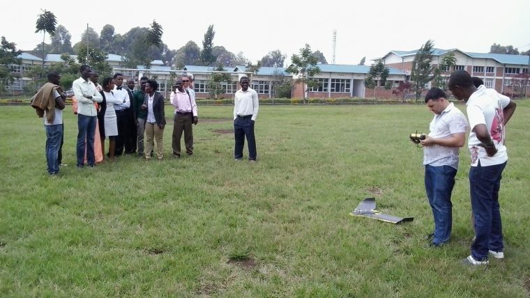
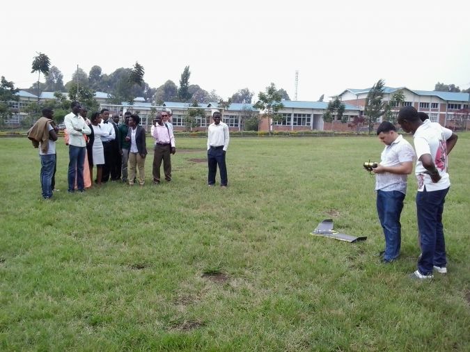
With the capacity development issue in mind, staff from ITC, INES Ruhengeri and ThinkSpatial (an Australian geospatial consultancy) met in Rwanda to explore the idea of embedding UASs into the land administration educational programmes of INES and Rwandan land administration more generally.
Orthomosaic
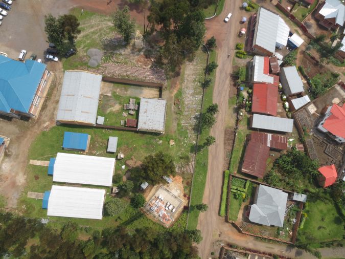
ThinkSpatial operates a sensefly eBee, which is a fixed-wing ultra-lightweight UAS with a 1m wingspan. It carries a 16MP camera capable of providing 3.5cm imagery at a flying height of 115m. In Rwanda, the team captured imagery over the INES Ruhengeri campus in Musanze District to demonstrate the operation of the aircraft to staff and students and to illustrate the workflows and final products to the local land administration stakeholders. The demonstration, which took 15 minutes, covered an area of 12.5ha over which 120 images were captured to produce an orthomosaic of the campus.

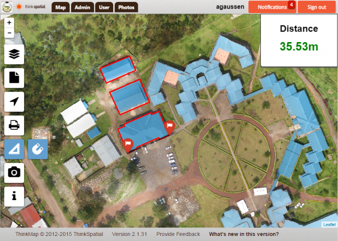
The processing of the dataset took 4 to 5 hours with the resulting products being orthoimagery, a digital surface model (DSM) and a 3D point cloud. The products were then loaded into ThinkSpatial’s cloud-based ThinkMap product. ThinkMap is a multi-device web-mapping tool that allows users to examine imagery, geospatial datasets and documents.
INES Ruhengeri students and staff quickly grasped the potential role UASs could play in their training programmes. However, any plans to incorporate the use of UASs for land administration in Rwanda will need to carefully address how a sustainable workforce capacity can be established.
Looking Ahead
The field demonstration carried out in Rwanda revealed that, despite the clouds, curious hawks and hilly terrain, UASs could be readily applied to land administration applications. The high-quality, high-resolution imagery and fast turnaround times appear to offer a great deal to the fit-for-purpose land administration model that has been adopted in Rwanda. Further work is needed to explore how best to undertake the vectorisation of parcel boundaries in a way that rekindles the participatory spirit inherent to LTR. The field visit also revealed that, whilst there is plenty of surveying equipment already within Rwanda, there is a lack of trained surveyors ready to use it. Although the country is investing in its professional land administration workforce (through the programmes offered at INES Ruhengeri and ITC), capacity development takes time. In the meantime, tools such as UASs and the para-surveying workforce could play a key role in delivering sustainable and fit-for-purpose cadastral updates.

Value staying current with geomatics?
Stay on the map with our expertly curated newsletters.
We provide educational insights, industry updates, and inspiring stories to help you learn, grow, and reach your full potential in your field. Don't miss out - subscribe today and ensure you're always informed, educated, and inspired.
Choose your newsletter(s)


