Geoinformation in Arable Farming
What’s Hot and What’s Not in Precision Agriculture
Agriculture enthusiastically absorbs geospatial technologies. Precision farming practices in particular benefit from location intelligence. The future in agriculture with geospatial applications is bright. Besides more efficiency on the farm, geospatial technologies also offer new business opportunities and new sustainability concepts. But the adoption of geospatial innovations is lagging behind expectations. So what’s hot and what’s not? This article examines the state of the art in geospatial technologies in agriculture and attempts to forecast the trends.
By Tamme van der Wal and Henk Janssen, Wageningen University & Research (WUR), The Netherlands
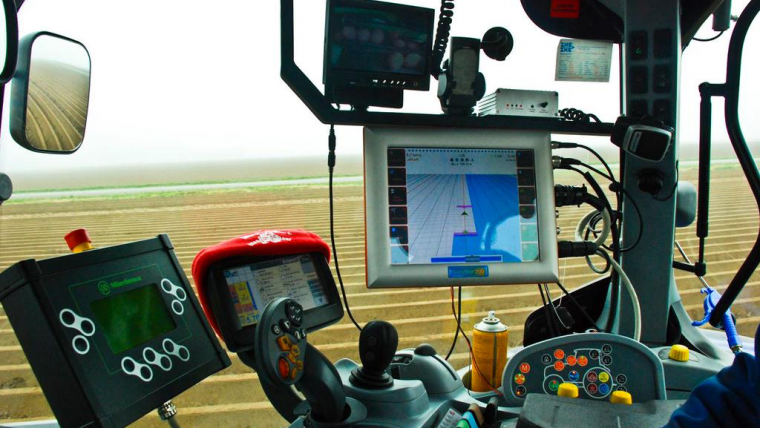
By far the most popular geomatics technology among farmers is the global navigation satellite system (GNSS). Since farmers have had steering aids and fully automated machine guidance, their efficiency in field operations has increased by 10 to 15%. GNSS is a very versatile technology; it also helps farmers to map their fields, geolocate objects and track and trace their machinery or livestock. One application that utilises GNSS as a guidance and tracking tool is the routing of machinery in the field. The first step in this is to accurately measure the field boundaries where a crop can be grown. This information is used to design the optimal layout of driving lanes, taking the width of machinery, turning angles and the field geometry into consideration. This enables the detection of areas with inefficient machine manoeuvring which, in the optimal path plan, are ideally moved to the side of the field and/or given another function (e.g. as a nature strip). With the advent of robotic field work, planning an optimal path is an efficient way of instructing machines where to go. The next step is to calculate the routing along these paths in order to optimise the bulk cargo capacity on board the field machines. For instance, an optimal route plan for fertiliser spreading would minimise the time and distance to reload fertiliser.
Satellites
GNSS is also an indispensable tool in what is called ‘variable rate application’: a method for giving the right dose of an input in the right place. Here, innovation is mainly driven by the use of sensors for environmental parameters, including soil conditions, water availability, vegetation monitoring and yield monitoring. Satellite remote sensing has always been an appealing way of monitoring large areas of agricultural land, but it is only recently that the Earth observation sector has become organised in such a way as to make operational data feeds to agriculture feasible. The European Sentinel satellites, which form part of the Copernicus programme, have given rise to new optimism since the continuous monitoring and the download functionality are unprecedented, at least in the public domain. The only drawback is that agricultural applications mostly rely on the optical sensors on board Sentinel-2, and successful imaging of agricultural land requires clear skies. Given the fact that 90% of agricultural land worldwide is rain-fed, the abundance of clouds in the growing season is an obstacle. Nevertheless, the minimum six-day revisit of Sentinel-2 is a significant improvement on Landsat-8 (16 days).
Unmanned Aerial Vehicles
For areas with too much cloud cover, unmanned aerial vehicles (UAVs or ‘drones’) are an excellent proxy. In a way, UAVs at last allow farmers to capitalise on almost 50 years of remote sensing knowledge and application ideas. Furthermore, the explosion of players in the marketplace, and their diversity, feeds innovation at every link in the chain between image acquisition and user application. For instance, software solutions for photogrammetry, image mosaicking, reflectance calibration, index calculations and related GIS functionalities are emerging at an incredible pace.
As in other sectors, UAVs are a major hype. The technology and regulations are improving every day, however, which means that at a certain tipping point the technology will become indispensable to all. And although UAVs are currently mainly regarded as platforms for sensors, they can also become the next-generation tractor on which all kinds of crop care implements will be installed. This capability is demonstrated by a Japanese application in which unmanned helicopters perform crop spraying, for example.
From an agricultural point of view, to optimally benefit from all these technologies the farmer must have an integrated system for the collection, storage, analysis and visualisation of all the data and tools. In this domain, too, the pace of advancement is very high: machine manufacturers, farm equipment suppliers and input suppliers (i.e. fertilisers, seeds, etc.) are offering data management tools with a geospatial interface. This is also attracting start-ups from various backgrounds who need little more than a software platform as a vehicle to create business value with their specific proposition.
Business Opportunities
The rise of precision farming and the use of geospatial technologies bring all kinds of new business opportunities in domains including sensoring (data and/or equipment supply), machine guidance (and path planning), geospatial-based office applications to work with soil maps, remote sensing imagery, yield monitors and crop growth optimisation/decision support, not to mention a whole world of maintenance and support for all these new technologies. In this context, it is impossible to ignore The Climate Corporation, which is now part of Bayer through recent acquisitions. With Climate Corp data, Monsanto and now Bayer are able to combine soil, weather and crop growth information to prescribe which seeds and which agents are best suited for every field on Earth. And as they apply it to a huge set of customer information, this has become a totally new way of farming, called ‘prescription farming’ or ‘decision farming’. Other opportunities involve market prices and crop acreages, allowing calculation of whether an additional supply of fertiliser or water will increase the yield sufficiently to deliver a payback or not. In another opportunity, on-demand growing and delivering of food now seems not too far off, although it also depends on the crop of course. This trend is already visible in horticulture – the non-geospatial agricultural example for arable farming – where retailers (in particular the emerging foodbox companies) are creating better demand-driven supply chains.
The most important question here is, do the investments and benefits coincide? Or are farmers the ones making the investments, while their suppliers and customers reap the benefits? While it is easy to make a clear business case for suppliers of machinery, fertilisers, seeds, agro-chemicals, etc. and for customers in the agrifood chain including retailers and food processing companies, farmers themselves have difficulties making a business case for precision farming investments. Although there are only a handful of studies addressing the adoption issue, they show clear benefits for farmers when applying precision farming technologies – not only in resource efficiency (costs savings), but also in quality increases and yield increases. However, despite these positive studies, the impact on the farm’s business is variable. In particular smaller farms can be reluctant to invest when the payback time is 10 to 15 years or more. The technological framework is very wide and complex. It is not easy to oversee the consequence of a choice for a certain brand or operational method. Certainly, the poor connectivity in many rural areas poses challenges in obtaining and sharing the data needed for precision farming applications. And, as mentioned above, the eagerness to ‘own’ a data platform so as not to miss out on the next level of farming is also leading to a lack of interoperability at all levels. Another major issue here is education, both at academic and vocational level, with a new generation of farmers only now (finally) starting to learn and experience the benefits of precision farming for themselves. Hence this is another opportunity for new businesses: forming collaborative partnerships with other farms can create the economies of scale necessary to reap the benefits from precision farming. Agriculture already has a tradition of doing this, e.g. mill cooperatives or machine-sharing schemes.
Sustainability
Despite increasing societal demands for farms to produce the best possible food in a sustainable way, the slow adoption of precision farming is holding back sustainability improvements most of all. Precision farming technologies could dramatically reduce the ecological footprint of food production: 10-15% less energy use (fuel) and 10-20% lower inputs (e.g. crop protection agents, fertilisers and water) for the same level of production or, in other words, increased productivity per kilogram of fertiliser, litre of fuel, litre of water or man-hour. Hence there is an incentive for governments to stimulate the adoption of precision farming, as it will contribute to solving environmental issues as well as mitigating farming’s contribution to greenhouse gas emissions. This is already resulting in new regulations. The European Commission is investigating opportunities to extend its concept of ‘greening’ towards the uptake of precision farming. This would imply that adopting these new technologies will increase one’s ‘licence to operate’; in other words, the technology will help farmers to improve acceptance of their activities by their neighbours, their personnel, their customers and by society at large. Needless to say, geoinformation will play a key role in achieving and monitoring this greening concept.
Trends
Agriculture will benefit from the revolution in information & communication technology taking place in all industries: robotisation, sensoring, smarter decision support systems, data analytics, etc. For the geospatial domain, the robotisation of field work is a particularly important challenge. It is a huge operation to guide robots – either on wheels or in the air – using navigation systems and sensors, to store all the data and integrate it in the relevant applications. But robots will eventually take over the dull, dangerous, dirty and perhaps even difficult jobs that are abundant in agriculture.
Furthermore, changes in society will cause a growing shift towards more demand-driven supply chains, requiring further integration of the business processes between the farmer and his suppliers on the one side and between the farmer and his customers on the other. That integration must lead to better chain performance and more optimal food production.
This article has focused on the application of geospatial data, tools and knowledge on farms themselves. Clearly geoinformation plays an important role in other areas of food production too, such as global food security monitoring, logistics, measures for disease containment, ways to administer and control subsidies and contracts, etc. In that sense, agriculture is no different to other industries, except that the ‘factories’ are outdoors and the machinery is mobile.
Biographies of the authors
Tamme van der Wal works as a data scientist at Wageningen University & Research (WUR) where he is studying the development and adoption of digital farming. Over the past years he has been involved in studies for the European Commission, OECD and the Dutch Ministry of Economic Affairs into the relevance of drones and precision farming for improving agriculture. Furthermore, he is investigating the impact of digital farming on ‘greening’ and climate mitigation.
Henk Janssen works as a team leader at Wageningen University & Research (WUR). He has a special interest in precision farming and its opportunities for meeting the challenges in maintaining soil quality, reducing greenhouse gas emissions and ensuring optimal in-field route planning. In his team, the focus is on environmental data collection and the quality of data for monitoring purposes.

Value staying current with geomatics?
Stay on the map with our expertly curated newsletters.
We provide educational insights, industry updates, and inspiring stories to help you learn, grow, and reach your full potential in your field. Don't miss out - subscribe today and ensure you're always informed, educated, and inspired.
Choose your newsletter(s)


