Geospatial Data in Support of 3D Cadastre
Zooming in on Recent Technical Developments
This article was originally published in Geomatics World.
The urbanization trend is leading to an increasing number of people living in cities, thus also placing new demands on cadastral registration. To be able to register the complex infrastructures and built-up areas properly, the cadastre will need to consider the third spatial dimension. The 3D cadastre is based on 3D parcels (spatial units) which are single volumes (or multiple volumes) of space. Although the technology offers numerous possibilities for implementation of the 3D cadastre, there are still some open issues, as this article explains.
We live in a three-dimensional world. Over the past decades, there have been an increasing number of 3D situations in which different property units (with possibly different types of land use) are located on top of each other or constructed in even more complex structures (see the examples in Figures 1 and 2). The traditional cadastres based on the 2D parcel paradigm do not provide sufficient tools to register and display such situations efficiently.
LADM
The international standard ISO 19152:2012 Land Administration Domain Model (LADM), which brings support for 3D parcels, defines a conceptual model covering basic information-related components of land administration (including those over water and land, and elements above and below the surface of the Earth). The LADM provides a reference model which serves to provide an extensible basis for the development and refinement of efficient and effective land administration systems, based on a model-driven architecture (MDA), and to enable involved parties, both within one country and between different countries, to communicate based on the shared vocabulary (i.e. an ontology) implied by the model.
LADM provides an abstract, conceptual model related to parties (people and organizations), basic administrative units, rights, responsibilities and restrictions (ownership rights), spatial units (parcels, and the legal space of buildings and utility networks), spatial sources (surveying) and spatial representations (geometry and topology). Furthermore, LADM provides terminology for land administration, based on various national and international systems. The terminology allows a shared description of different formal or informal practices and procedures in various jurisdictions. Last but not least, LADM provides a basis for national and regional profiles and enables the combining of land administration information from different sources in a coherent manner.
3D cadastral information modelling
Cadastral data models (e.g. LADM) including 3D support have been developed for legal information modelling and management purposes. The various aspects of 3D cadastral information modelling need to be addressed, e.g. the possibilities of linking 3D legal rights, restrictions and responsibilities (RRR) spaces, modelled with LADM, with the physical reality of 3D objects (described via CityGML, IFC, InfraGML, etc.). This is closely related to the legal framework and initial registration of 3D spatial units (3D parcels).
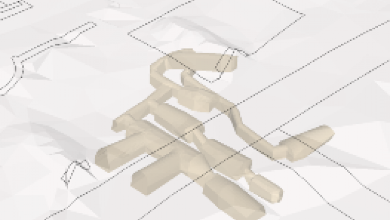
An initial categorization of 3D parcels was set up (Thompson et al., 2015) and formed the starting point for the further investigations into suitable corresponding database representations, exchange formats and data capture encodings. Figure 3 displays a general 3D spatial unit which can be defined by boundaries other than horizontal and vertical.
Two remaining challenges that depend on country-level decisions are the definition of what are acceptable (valid) 3D cadastral object representations, and how to create their 3D geometries (even non-2-manifold geometries). The non-manifold 3D representations (self-touching in edge or node) are not well supported by current GIS, CAD and DBMS software nor by generic ISO standards such as ISO 19107 (Van Oosterom, 2013).
3D spatial database management systems
The 3D spatial database management system (SDBMS) should support a data model to handle a variety of 3D objects, 3D geospatial data quality control, 3D analysis, high-performance dissemination of 3D geospatial data and real-time rendering. It should also support the related 3D standards. Although a lot of work has been completed on defining a 3D vector geometry in standards by the OGC and the ISO, it is still insufficient to define 3D cadastral objects. 3D objects have a more rigorous definition for cadastral purposes. For a volumetric 3D cadastral object, for example, the polyhedron needs to satisfy characteristics such as closeness, interior connection, face construction and proper orientation.
As with 2D geometry, 3D volumetric primitives would need to satisfy the adjacency and incidence (gaps and overlaps) relationship so that they are mutually exclusive and spatially exhaustive in the domain. While standards and definitions for solids exist, such as the PolyhedralSurface in the SQL Geometry Types of OGC as well as other definitions for solids, they are currently not well utilized and do not comply sufficiently with standards. It is highly problematic to validate such solids and exchange datasets between formats and platforms. This does not usually follow any standards, and error reports are usually cascading rather than in a single report, thus making it very cumbersome to deal with errors individually.
LADM addresses many of the issues in 3D representation and storage of 3D data in a DBMS. It allows in-row storage of 3D data in a mixed 2D/3D database allowing for fast retrieval and analysis; it allows for 3D data to be stored in different levels of detail, overlapping 2D footprint of 3D objects, and supports liminal parcels; and it allows attribution of different boundary lines and faces. However, one identified issue is the duplication of the definition of boundaries for separate spatial units.
Three-dimensional objects can also be represented using voxels (volumetric pixels). This brings advantages in object representation, object count and volume, 3D operations and simple analysis, and represents 3D as a solid instead of point, line and polygon. The challenges to this are the storage and efficient handling by current spatial databases. However, some GIS systems are working towards creating a column store structure to accommodate voxels.
Another possibility is to represent 3D objects as a point cloud. Lidar point clouds could assist in terms of being a reference framework of as-constructed features, or a 3D data acquisition tool for 3D physical objects, or a verification tool for pre-existing building information modelling (BIM) or other models. Point cloud data can be used for data such as administrative, vector, raster, temporal, etc., and SDBMSs should be able to combine this data for a point cloud data type with characteristics such as xyz values, attributes per point, spatially coherent data organization, efficient storage and compression, data pyramid support for multi-scale or vario-scale support, temporal support, query accuracy over a range of dimensions, analytical functions and parallel processing.
Spatial indexing is used by SDBMSs to improve search speeds. Of the three types of indexes, namely B-Tree, R-Tree and GiST, the latter two are found to be useful for 3D GIS data. Operations on and amongst 3D objects have been described by OGC, such as 3D architecture (Envelope(), IsSimple(), Is3D(), etc.) and spatial relationships (Equals(), Intersects(), Touches(), etc.). However, existing SDBMSs often implement them differently.
3D topological structures are an important consideration in a 3D cadastral SDBMS. Topological relationships between neighbouring parcels can be between two objects or between many of the object’s neighbouring parcels. While 3D topological structures have been defined, they are not fully compliant with standards such as LADM. LADM not only provides a conceptual description of a land administration system, but also provides a 3D topology spatial profile. LADM also stipulates that geometrical information along with an associated topological primitive help to describe 3D spatial units. LADM volumes can be bounded or unbounded at the top or bottom which is a reflection of real-world situations where there may be limited or unlimited rights or restrictions on the ground or in the skyward direction of a volumetric property. The approach based on the Tetrahedral Network (TEN) model is a suitable 3D topological model for volumetric parcels and is proposed as an alternative to boundary representation. The 3D topology model based on TEN synchronized with LADM specifications and the development of conceptual and physical model seems to be suitable for 3D cadastre and 3D registration. This topological model would utilize surveying boundaries to generate 3D cadastral objects with consistent topology and rapid query and management.
Visualization
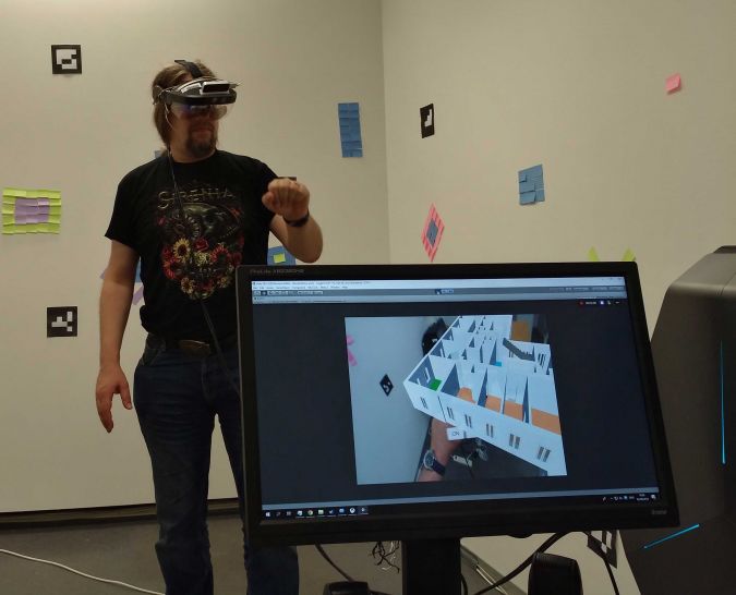
The example in Figure 3 shows how difficult it can be to grasp the geometry of a 3D object represented as a 2D drawing. Even trained experts might have difficulties to assess the vertical gap between the two ends of the object. This might prevent people untrained in geometry or CAD – like lawyers or managers – from understanding complex situations. A possible solution could be the use of mixed reality (MR) technology which allows visualization of models in 3D. Special glasses blend digital information, e.g. the representation of a 3D model, into the user’s field of vision. Since each eye observes the model from a slightly different perspective, the user perceives the model in 3D. Importantly, the reality is still visible for the user in MR, which minimizes virtual reality sickness and enables the user to avoid collisions while moving around.
Figure 4 shows MR in action at the TH Vienna Spatial HCI Lab. Wearing special glasses, the user sees the model shown on the computer screen. The model is a 3D representation of an apartment building, with the apartment ownership visualized as a holographic model. Different floor colours represent differences in ownership in this model (Navratil et al., 2018). The glasses include sensors for hand detection, thus allowing interaction with the model – in this case, grabbing a floor and relocating it in the space. The interaction is more intuitive than in 3D CAD because it imitates interaction with real desktop objects, e.g. moving a book. This reduces the frustration level among users.
Revision of ISO 19152:2012
During the 47th ISO meeting week in Wuhan, China, in November 2018, the scope of the revised ISO 19152:2012 standard was agreed. The new version of the ISO 19152 is going to be significantly extended for new packages and annexes. For example, the new ISO 19152 will also consider the spatial planning information because it is necessary to integrate legal and spatial planning information, e.g. spatial planning regulates the total height of a building on a parcel. The ISO 19152 package dedicated to spatial planning information supports geometry objects which represent spatial planning hierarchy and geometric characteristics, facilitates information in spatial planning zoning and describes communities and their role in spatial planning.
Legal spaces and legal objects have their own geometries, which in many cases are not aligned with physical spaces and physical objects. The legal space should be linked to physical objects. BIM/IFC or CityGML offer options in this respect. Therefore, the revised version of ISO 19152 should contain the examples of LADM technical encodings in BIM/IFC and CityGML respectively. BIM is important in order to establish a link between BIM and land administration in relation to spatial planning and the whole lifecycle of a building.
Conclusion
Over the last 20 years, researchers and professionals have paid significant attention to the 3D cadastre. Nowadays one can find examples of legislation supporting the registration of 3D spatial units around the world (Sweden, the Netherlands, Queensland, Victoria and big cities in China like Shanghai). The registration of 3D spatial units can be seen as the first step towards the 3D cadastre. However, the organizational and technical aspects also have to be addressed. Although some countries already support the registration of 3D spatial units, this is done mostly using 3D drawings (e.g. a survey sketch capturing the 3D geometry of the object or a 3D PDF file showing the legal extent of 3D spatial units). To enable the effective functioning of the 3D cadastre, the 3D data must become an integral part of the cadastral spatial database. To meet this condition, the necessary steps are standardization in the field of 3D cadastre (ISO 19152 LADM), 3D information modelling (e.g. 3D LADM-based country profiles) and further development of 3D spatial databases. Another important technical aspect of the 3D cadastre is in relation with other initiatives like BIM. The capturing of 3D data is often seen as the most expensive phase of establishing the 3D cadastre. Re-usage of data like BIM could help to resolve this issue. The usage of BIM for 3D cadastre purposes has already been addressed in the literature.
Further Reading
Navratil, G., Schwai, M., Vollnhofer, S., Konturek, P., Giannopoulos, I. (2018). From Floor Plans to Condominium Rights Through an Augmented Reality Approach. 6th International FIG Workshop on 3D Cadastres. Delft, The Netherlands.
Thompson, R., van Oosterom, P., Karki, S., Cowie, B. (2015). A Taxonomy of Spatial Units in a Mixed 2D and 3D Cadastral Database. FIG Working Week 2015 – From the Wisdom of the Ages to the Challenges of the Modern World. Sofia, Bulgaria.
Van Oosterom, P. (2013). Research and Development in 3D Cadastres, Computers Environment and Urban Systems (2013)

Value staying current with geomatics?
Stay on the map with our expertly curated newsletters.
We provide educational insights, industry updates, and inspiring stories to help you learn, grow, and reach your full potential in your field. Don't miss out - subscribe today and ensure you're always informed, educated, and inspired.
Choose your newsletter(s)


