GIS Landslide Hazard Map of Romania
Tool for Disaster Management and Spatial Planning
GIS landslide-hazard maps are a common and useful tool for people involved in disaster management, spatial planning and disaster recovery, providing an image of the most susceptible areas and so enabling better pre-, during and post-event decision-making. In assessing regional landslide hazards several issues must be considered. The place and time when a landslide may occur, its dimensions, how fast and far it will travel, the chance of human injury or damage to manmade objects, the frequency of landslides in a certain area, and the impact of future climatic change.
This research was carried out due to a World Bank project on losses and insurance costs relating to disasters in Romania, and aims to provide a unitary basis for addressing landslide hazards in the country. It takes into account the most important triggering factors, as well as settlements and infrastructure affected by landslides. It also forms the basis for elaboration of a landslide-hazard risk map in an attempt to quantify all potential losses related to this process.
Geomorphic Hazard
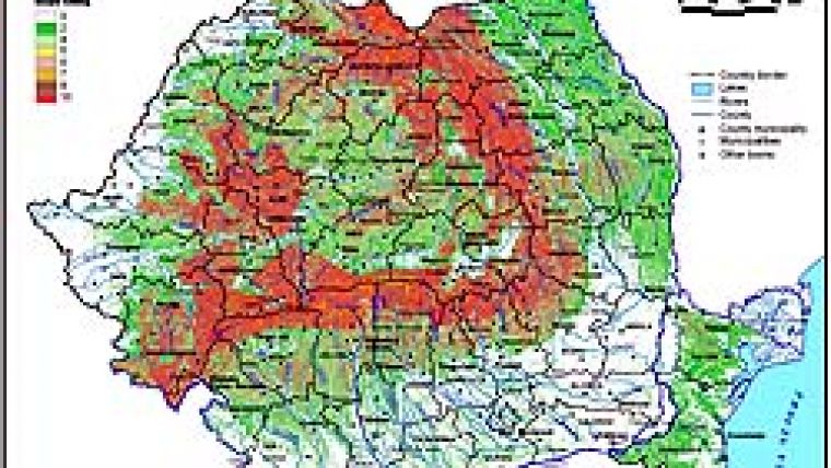
Landslides represent a common geomorphic hazard in Romania, threatening property and infrastructure mainly in the Carpathian Mountains and hilly regions, which account for more than 60% of the territory (Figure 1). In this regard Romania represents one of the countries most affected by landslides in Europe. Landslides are often associated with other major natural hazards, such as flood and earthquake. Although in Romania the number of human victims of this natural hazard is very low, landslide causes substantial damage to human property in affected regions. An increase in landslide frequency and magnitude has been observed in recent years, related to extreme rainfall resulting from climate change.
Models and Methods
A number of qualitative and quantitative models and methods are available for computing landslide-hazard and susceptibility maps, e.g. likelihood ratio, neutral network, logistic regression, and fuzzy-logic models. The choice of one or other is based on several elements, including the scale of assessment, degree of detail in a study, data availability and the purpose of the study. For our landslide-hazard risk map we use a Landslide Hazard Index (LHI) method based on quantitatively defined weighted values. Expert analysis, combined with a long history of landslide mapping and assessment and field experiments, play an important role in this method. The expert judgement involved a large number of studies and assessments undertaken at different scales, and geomorphological mapping of Romanian territory at the scale of 1:200,000.
Triggering Factors
In computing a GIS landslide-hazard map of Romania six major triggering factors were considered: lithology, height difference, slope angle, land use, rainfall and seismicity. Each factor was classified under sub-classes carrying a rating from 0 to 10 according to its relevance for landslide susceptibility. Further, each factor was considered to have a differential influence on such susceptibility, named ‘assigned weight'. The results were compared with different assessments from several countries. To validate the methodology, besides expert judgement, repeated geomorphic mapping over a long period, as well as field observations and measurements in the most affected regions, were used. Figure 2 shows an example of a lithology-rating map based on 1:200,000 scale map elaborated by the Institute of Geology, Romania.
Hazard Classes
The LHI was further classified under five hazard classes; each category based on correlation of expert judgement and existing geomorphological maps of the whole of Romania. The established classes are ‘no hazard', ‘low', ‘medium', ‘high' and ‘very high' hazard, as shown in Figure 3. Generally, the ‘no hazard' class represents around 39% of Romania (plains and low hills), ‘low hazard' 10%, ‘medium hazard' 38.3%, and ‘high' and ‘very high' hazard classes around 10% (mostly in the Subcarpathian region).
In the Subcarpathians landslides demonstrate a wide variety of form, and distribution is mostly controlled by lithology. The largest affected area corresponds to clay-based hill slopes and marls with secondary intercalation of sand. Shallow landslides are the most widely distributed over the area, being 1-1.5m thick, having moved over limited distances (10-15m to 20-30m), and having vegetation as soil fixation. Deep landslides (Figure 5) occur frequently on 5-150 slopes along valleys 40-50m wide and 800-1,500m long. Here an active phase of material movement along the valleys is followed by long intervals (thirty to a hundred years) of relative stability. The displaced deposits are 7-10m thick, occasionally thicker, and often associated with mudflows. Some other massive landslides occur on non-fragmented slopes. In most cases these represent reactivation of old landslides due to heavy rainfall, shocks from strong earthquakes of magnitude ML>7 on Richter scale, human intervention in the stability of the slopes, and natural or artificial overload of slopes.
Risk Factors
More detailed information and maps may be produced for specific sites using hazard maps including some risk factors: population number or density, surface of affected built-up area, number of buildings etc.
Figure 4 indicates the distribution of built-up areas at county level in the above-mentioned hazard classes. The county of Buzãu in the Curvature Carpathians and Subcarpathians, the seismic region of Vrancea, has the highest surface in the ‘very high' hazard class (around 20%). Two counties (Bacãu and Vaslui) situated in the Moldavian Tabeland have the highest surface for the ‘high hazard' class (over 30%).
Detailed Studies
The method was validated in the most affected regions based on detailed geomorphological mapping and observations, and its accuracy was proven to be relatively high. Depending on data availability in a given region, all landslide-hazard methods can be improved by adding other relevant parameters to increase accuracy. The Romanian LHI can be improved by considering other parameters significant to landslide: climatic (rainfall in 48 and 72 hours, and intensity), anthropic (e.g. roads), soil parameters and so on. The LHI map is a useful tool for selecting for more detailed study areas most affected by landslides. More detailed studies may then be undertaken and risk maps computed for localities within the area. In Romania this is done in Bend Subcarpathians, one of the most affected areas.
Acknowledgments
The authors would like to thank Dr Petru Enciu for help with lithology assessment, and RMSI for logistical and scientific support.
Further Reading
-
Glade, T., Anderson, M., Crozier, M. (eds.), 2005. Landslide Hazard and Risk, Wiley, p 824.
-
Balteanu, D., Jurchescu, M. (eds.), 2008, IAG Regional Conference on Geomorphology. Landslides, Floods and Global Environmental Change in Mountain Regions, Field Guidebook, University Publishing House, p 130.
-
Balteanu, D. et al (eds.) (2006), Romania. Space, society, environment, Publishing House of the Romanian Academy, p 384.

Value staying current with geomatics?
Stay on the map with our expertly curated newsletters.
We provide educational insights, industry updates, and inspiring stories to help you learn, grow, and reach your full potential in your field. Don't miss out - subscribe today and ensure you're always informed, educated, and inspired.
Choose your newsletter(s)


