GlobeLand30: A Milestone in Earth Observation and Open Access Geospatial Information
During a ceremony on 22 September 2014, UN secretary-general Mr Ban Ki-moon praised China’s donation of the world’s first 30-metre-resolution global land cover (GLC) dataset, GlobeLand30, to the United Nations. He said: “The world needs solid, science-based information for making wise decisions for sustainable development. This donation is very timely and precious. Tomorrow, global leaders will gather at the United Nations to participate in the Climate Change Summit and to confirm their commitments to action. These detailed datasets will help us to better understand, monitor and manage changes in land cover and land use all over our planet. I commend you for this laudable example of information sharing.” [http://unstats.un.org/unsd/GlobeLand30.htm]
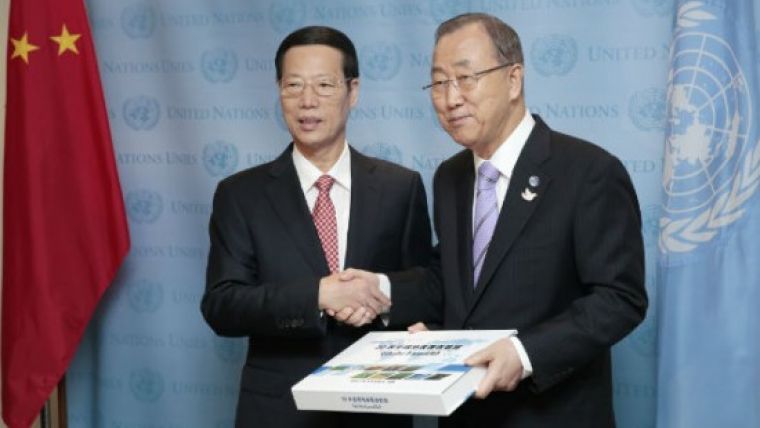
UN secretary-general, Mr. Ban Ki-moon, officially received the GlobeLand30 from Mr Zhang Gaoli, vice premier of China, on 22 September 2014.
Over the past four years Professor Chen Jun, ISPRS president and chief scientist at the National Geomatics Center of China, and his team have processed over 20,000 Landsat and Chinese HJ-1 images to cover the Earth’s entire land surface (approx. 150 million km2) and to derive ten land cover types at global scale for two years: 2000 and 2010. A number of factors, including the availability of good-quality imagery covering the whole Earth and the complex spectral and textual characterisation of global landscapes make 30m-resolution GLC mapping extremely technically challenging as well as demanding in terms of human and financial resources, which explains why so far only global datasets with limited classes at 30m resolution have been reported. The production of GlobeLand30 2000 and 2010 by Professor Chen Jun and his team within a four-year period is a milestone achievement in the history of obtaining global geospatial information from satellite imagery, and can also serve as a successful example of big-data mining.
In comparison with the existing GLC datasets ranging from 300 to 1,000m resolution, GlobeLand30 provides more-detailed land-cover patterns and their changes induced by human activities between 2000 and 2010. Preliminary results from an initial validation of the global water layer of the GlobeLand30 conducted by KTH Royal Institute of Technology (Sweden) and the International Institute for Applied Systems Analysis (IIASA) in Northern Europe show that accuracy of GlobeLand 30 (total disagreement less than 5%) was much higher than other existing GLC products.
The full datasets of GlobeLand30 are now freely available on the website [http://www.globallandcover.com/GLC30Download/index.aspx]. The open access of this important scientific dataset will significantly promote scientific data-sharing and decision-making in the field of Earth observation and geospatial information sciences within the international community.
Recognising the importance of GLC information, ISPRS decided during its 2012 Congress in Melbourne to establish an Inter-Commission Working Group on Global Land Cover Mapping and Services involving three of its eight technical commissions (TC II, IV and VIII) to coordinate international efforts on identifying scientific, technological and application challenges related to GLC mapping, validation and web services of GLC data. I would like to take this opportunity to call for your participation in the continued validation and refinement of GlobeLand30 and other GLC products and collaborative information services. I would also like to congratulate Professor Chen Jun and his team on this remarkable achievement.
Yifang Ban, chair of ISPRS ICWG II/IV/VIII on Global Land Cover Mapping and Services and professor of geoinformatics, KTH, Stockholm, Sweden.

Value staying current with geomatics?
Stay on the map with our expertly curated newsletters.
We provide educational insights, industry updates, and inspiring stories to help you learn, grow, and reach your full potential in your field. Don't miss out - subscribe today and ensure you're always informed, educated, and inspired.
Choose your newsletter(s)


