Growing Use of Oblique Imagery by Municipalities
Seeing More from Above
For municipalities, aerial imagery is a vital support for geospatial and thematic information extraction and planning processes. Until recently, only orthophotos produced by nadir aerial images were used for this, but the development of oblique-image cameras is opening up new possibilities. Cases in 3D cartography, urban damage assessment and urban planning demonstrate the high value of these images and derived geospatial products.
Since the early 2000s, oblique camera systems have been used for well-known applications such as the visualisation of buildings roofs and façades from a 360-degree perspective, realistic texturing of 3D city models and measurement of building heights in monoplotting mode. The inclusion of oblique images for the extraction of accurate 3D value-added products is also growing in importance today. That is made possible by larger sensor size, better radiometric and geometric resolution of the imaging systems, and the availability of new software solutions for image processing.
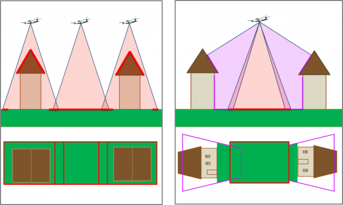
The immediate advantage of acquiring images from an oblique perspective is the possibility to view elements that are generally occluded in the vertical views by vegetation or higher structures; there is an additional perspective on objects such as road edges and lower building parts (Figure 2). Also, the determination of the vertical component of point ground coordinates is more accurate, due to a more stable stereo geometry. Another advantage is that the higher degree of image overlap, typical for oblique projects, favours dense point cloud generation and true-orthophoto production. Comparing 3D point clouds based on nadir images or Lidar sensors only to point clouds generated by nadir and oblique images proves that the latter are more complete. They model roof details, overhanging roofs, building façades, the front side of vertical elements or other features generally not visible in the nadir views. This explains the growing number of requests by municipalities for aerial photogrammetric flights using oblique cameras.
Between 6 and 10 Images Per Object
An important question when proposing new technologies in smaller municipalities is, of course, the cost-benefit ratio. The costs of aerial photogrammetric flights with oblique cameras strongly depend on the settlement structure and the area to be covered, but are certainly higher than the nadir flights. That is due to the increased overlap between strips and the addition of a minimum of two strips on the borders for full oblique coverage of the area. Nevertheless, the employment of the oblique images can potentially reduce the field survey by the municipal staff and transfer part of the surveying operations to the office, if a proper measurement tool is available. At AVT, an Austrian company that operates oblique aerial flights with UltraCam Osprey cameras together with subsidiary Terra Messflug, flight strip overlaps are planned so that each object is captured on an average of six to ten images in each viewing direction. This ensures that there is almost always a recording that represents the object in question. Another important question is the usability. In smaller communities, geoinformation is often handled by staff whose main educational background or field of work is not GIS or surveying. This requires community geodata to be both easy to use and hard to abuse. Therefore, in addition to the aerial images themselves, municipalities need a tool to explore the images and carry out (3D) measurements with a user-friendly GUI and clear functionalities. To fulfil the requirement for easy image visualisation and mapping, AVT – in cooperation with the Bruno Kessler Foundation research institute based in Trento, Italy – has developed software called ‘Geobly’. AVT itself uses Geobly for high-precision oblique photogrammetric surveys.
Urban Mapping and Management
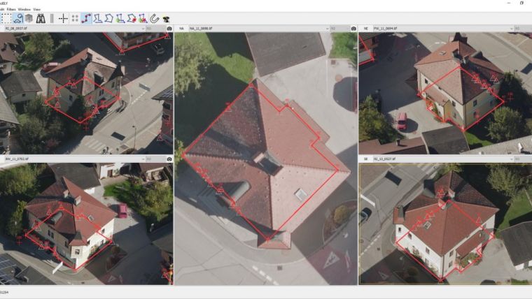
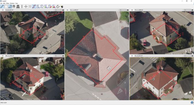
The added value of oblique imagery and Geobly lies in urban mapping and management, as demonstrated in the small town of Kundl in Austria. The town is located in an economically strong region, with a growing population and thus lively construction activity. In conjunction with the update of the cadastral information, the municipality decided to fly with an oblique digital camera and obtain – in addition to the standard photogrammetric products (i.e. digital terrain model, orthophoto, stereo plotting measurements) – comprehensive basic data for the civil authority, as well as a clearer presentation of all objects from several perspectives. The images were acquired with a ground sample distance of 5cm and oriented with aerial triangulation. Geobly was made available to the community of Kundl in order to measure metric information of interest at any time. A careful comparison of terrestrial measurements and measurements from the new tool validated the accuracy of the photogrammetric products.
The town of Kundl uses oblique images for a number of applications: 1) In the civil department, all planned changes in the buildings are reviewed and documented, e.g. whether a carport or a patio is inadvertently laterally closed. In the past, a person was sent to document it on-site; 2) The analysis of the building structure as a basis for planning activities, and the determination of the number of floors and building heights (Figure 3), benefits the urban planners and building engineers; 3) The mapping of terrestrial and vertical traffic signs, which are very clearly recognisable in the images; 4) With respect to more efficient cartography and map updates, Geobly simplifies the recognition of the map elements by enabling the overlay of existing vector information (e.g. cadastral datasets) on the images. Based on this information the photogrammetric restitution from the oblique images at AVT is an integrated part of the map database update cycles; 5) In the fire protection assessment of industrial complexes and the neighbouring buildings, the oblique aerial images make it possible to check fire safety regulations and to determine escape and evacuation routes, to document suitable methods of entry, hard-standings and movement areas, etc. Back in the municipality office, it can therefore be quickly clarified whether the requirements are met; and 6) The town of Kundl plans to use the oblique imagery results for city planning purposes and location marketing in the preparation of virtual tours.
Earthquake Damage Assessment
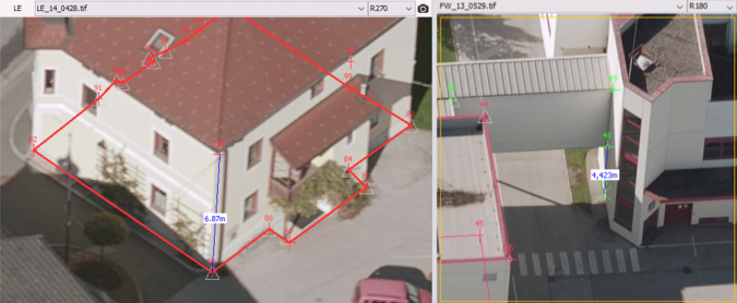
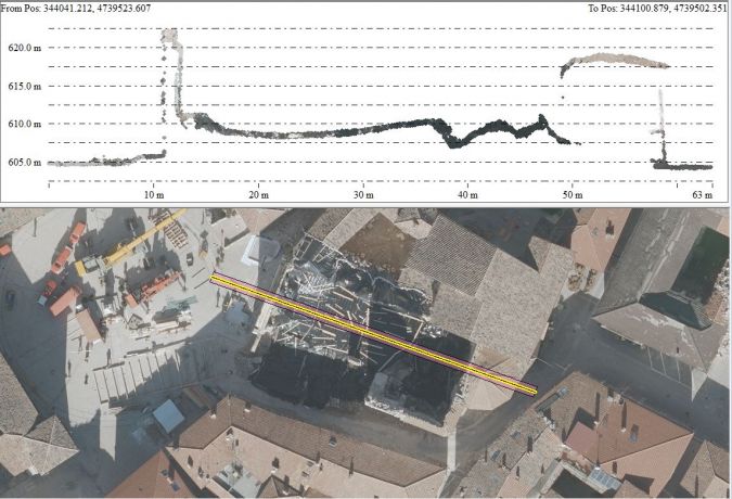
The use of oblique imagery was also very beneficial for the small town of Norcia, located in the central part of Italy. It was heavily damaged during the severe earthquakes in October 2016. AVT executed an aerial flight for the energy company Engie Italia, and acquired aerial images from five different viewing angles. A 3D model of the priority areas was generated and the local municipality was provided with a user-friendly tool for height and planimetric measurements. In this project a novel acquisition strategy for oblique imagery was successfully tested, based on the combination of a nadir camera with suitable focal length and a flight plan with two overlapping perpendicular blocks. The images were acquired with a ground sampling distance of 5cm (1 GSD). A dense image matching procedure (SURE, www.nframes.com) was applied in order to produce a 2.5D digital surface model (DSM), a 3D point cloud with a mean spatial resolution of 1 GSD, and a 3D mesh model at a resolution of 2 GSD. The interpolated 3D surface model of the damaged areas allowed the identification of the shapes of the buildings, the collapsed parts and the ruins on the ground in detail (Figure 4). Thanks to the oblique views of the historic area, even narrow alleyways were clearly visible in the images and could be modelled. A quantitative assessment of the damage was possible through measurement of distances, areas and volumes in the point clouds or measurement of building heights.
3D City Modelling
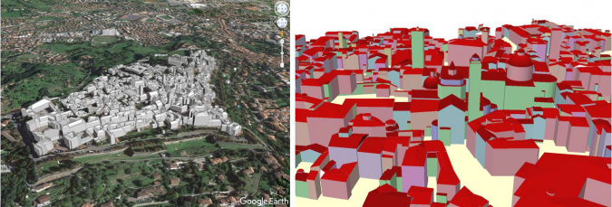
Accurate 3D city models are a core element of modern urban mapping and represent an important source of information to support various (smart city) applications, such as space management, energy assessment, 3D cadastre, noise and pollution propagation or disaster management. The Municipality of Bergamo, a city of about 120,000 inhabitants in northern Italy, requested an oblique image flight for the generation of a 3D city model of the historical centre (approx. 1.2 x 0.8km) that is situated on a hilltop. Surrounded by 16th-century Venetian walls, it features old mediaeval buildings with complex and varying shapes, located on narrow streets in a densely built-up urban area. In terms of 3D geometry mapping and modelling, this scenario poses significant challenges due to visibility constraints that limit data acquisition from an airborne platform. Historical buildings with complex roof shapes complicate the use of standardised primitive shapes. For this reason the flight was executed with high overlap between consecutive images of the same strip (i.e. 80%) and between adjacent strips (i.e. 60%). Starting from the images (10cm GSD) and the aerial triangulation results, the multi-view matching pipeline provided by SURE was adopted to extract a filtered 3D dense point cloud with a mean spatial resolution of 1 GSD (60 million points). Secondly, a 2.5D DSM cloud over the entire city was made and also a true orthophoto at 1 GSD resolution. To extract the 3D city model from the 3D point cloud, the CityModeller tool in the tridicon/Hexagon suite (www.tridicon.de) was adopted, with the building footprint, the 2.5D DSM cloud and an available digital terrain model (1m grid) as input data. Once the automatic modelling was complete, building models were edited in the 3D Editor tool. This tool allows the user to import oriented images, superimpose the generated building polygons over them and edit the geometry according to the 2D reference. Since obliquely oriented images can also be used as reference, the complete Bergamo dataset (nadir and oblique imagery) was adopted here to support the manual editing of the generated building models. This allowed for more convenient viewing directions to be exploited in checking and adjusting complex roof shapes and building outlines. The final 3D city model of the historic part of Bergamo will be used in the city’s GIS environment (Figure 5).
Remaining Needs
Oblique aerial images enable an accurate, fast and clear recording of spatial data from within the office. The better identifiability of points (corners, roads, etc.) compared to vertical surveys has already proved its worth in municipalities. The interpretation of the image content is also easier for employees who are not practised in the daily use of orthophotos. But, of course, some customer needs and technological challenges remain. Recordings from different perspectives provide more information but also mean that large amounts of data are generated and processed. Therefore, there is a need for intelligent solutions for effective processing, management and interaction of big geospatial data. The widespread distribution of GIS in municipalities has also increased the demand for the inclusion of oblique image functionalities in a GIS environment in order to access all geospatial data in a single and familiar environment. With respect to the interoperability, the application software should be as simple as possible for professional and non-professional users, with the possibility to enter notes, sketches and symbols and export the information to standard file formats.
Oblique Imaging
Oblique aerial cameras consist of optical sensors, tilted with respect to the vertical direction, acquiring simultaneous images from different viewing perspectives. The most common camera design presents one photogrammetric nadir-viewing camera combined with four cameras tilted at an angle of between 30° and 50°, with forward-looking, backward-looking, left and right viewing directions.
The Austrian company AVT and its subsidiary Terra Messflug have been operating oblique aerial flights with UltraCam Osprey cameras since 2015 for public and private customers. They share some of their experiences in this article.
Acknowledgements
Thanks are due to the Municipality of Kundl and Engie S.p.A. for allowing publication of their data and to the Bruno Kessler Foundation for processing the Bergamo dataset.
Further Reading
- Moe, K., Toschi, I., Poli, D., Lago, F., Schreiner, C., Legat, K. & Remondino, F., 2016. Changing the production pipeline – use of oblique aerial cameras for mapping purposes. In: The International Archives of the Photogrammetry, Remote Sensing and Spatial Information Sciences, Prague, Czech Republic, Vol. XLI, Part B4, 631-637.
- Poli, D., Moe, K., Legat, K., Toschi, I., Lago, F. & Remondino, F., 2017. Use of vertical aerial images for semi-oblique mapping. In: The International Archives of the Photogrammetry, Remote Sensing and Spatial Information Sciences, Hannover, Germany, to be published.
- Toschi, I., Ramos, M. M., Nocerino, E., Menna, F., Remondino, F., Moe, K., Poli, D., Legat, K. & Fassi, F., 2017. Oblique photogrammetry supporting 3D urban reconstruction of complex scenarios. In: The International Archives of the Photogrammetry, Remote Sensing and Spatial Information Sciences, Hannover, Germany, to be published.

Value staying current with geomatics?
Stay on the map with our expertly curated newsletters.
We provide educational insights, industry updates, and inspiring stories to help you learn, grow, and reach your full potential in your field. Don't miss out - subscribe today and ensure you're always informed, educated, and inspired.
Choose your newsletter(s)


