GSDI 12 World Conference Report
‘Realising Spatially Enabled Societies' was the central theme of the Global Spatial Data Infrastructure meeting GSDI 12 World Conference, and provided food for thought and discussion during numerous paper presentations and workshops. The conference that took place at Suntec Convention Center in Singapore from October 19th to 22nd drew 650 delegates from 67 countries. Knowledge concerning enabling societies to become increasingly spatially oriented was therefore exchanged on a truly global scale, with participants networking and learning about technical, societal , legal and policy issues of spatial data infrastructures.
Professor Abbas Rabajifard noted in his opening speech the several incidents that the world had witnessed since the last GSDI World Conference in 2009 in Rotterdam: earthquakes in Haiti and Chile, floods in Pakistan, the oil spill in the Gulf of Mexico and eruption of the volcano in Iceland. All these disasters, whether manmade or natural, showed how increasingly exposed we were becoming to Mother Nature. It also demonstrated the growing significance of geographically referenced information in a central data infrastructure. According to Rabajifard, spatially enabled societies were about location, innovation and realisation. For instance three-dimensional visualisation will make it much easier to show dangers, not only to policy makers but also to the public. Three-dimensional visualisation too was about location, innovation and realisation, he explained.
Jack Dangermond, president of Esri, came to Singapore to receive the Global Citizen Award from the GSDI Association. Dangermond then took the opportunity to hammer home his message in a keynote address on the importance of environmentally responsible decision making for societies, underlining the role of geographical information in that process.
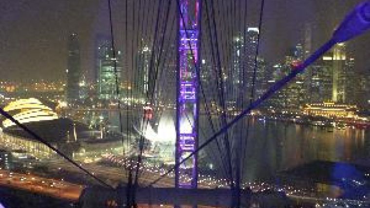
The global GSDI community gathered together in Singapore also had a chance to see with their own eyes what lack of environmental awareness is capable of in an urban, fast-growing region such as South East Asia. One of the social events was a tour on the Singapore Flyer, currently the world's biggest giant wheel. Under clear skies the bird's-eye view you get from this over the island state of Singapore, Singapore Strait and nearby Indonesia is spectacular. Not on this GSDI-organised night though. On the Indonesian island of Sumatra the rainforest is being razed to the ground at a pace previously unknown in order to prepare and plant large palm-oil plantations. The smoke from the burning of this precious rainforest was causing a haze over Singapore that prevented the delegates from seeing as far as normally would have been possible. Yet more evidence, graphic this time, for why we should be working and conferencing as hard as possible to encourage collaboration to help create an enabling environment that enhances outcomes in societies, economies and the global environment.
Co-organisers of the conference in Singapore were the Singapore Land Authority (SLA) and the UN Permanent Committee on GIS Infrastructure for Asia & the Pacific (PGIAP). The latter held its sixteenth regional meeting and the International Geospatial Society its inaugural meeting. The next GSDI World Conference will take place in May 2012 in Quebec City in Canada.

Value staying current with geomatics?
Stay on the map with our expertly curated newsletters.
We provide educational insights, industry updates, and inspiring stories to help you learn, grow, and reach your full potential in your field. Don't miss out - subscribe today and ensure you're always informed, educated, and inspired.
Choose your newsletter(s)


