Guiding Museum Visitors
Indoor Navigation at the Hubei Museum, Wuhan, China
Some museums have been guiding visitors through their exhibitions electronically using audio tours for decades. The audio content is triggered automatically when the visitor enters a room or stands in front of a display. Now that smartphones are ubiquitous, why not employ the latest technology for museum guidance? They are cheaper and more user friendly for visitors and museum management alike, and they can be more informative too. Challenged by this question, seven MSc students from the Delft University of Technology went to Wuhan, China, in early Autumn 2013.
Since 2000 various indoor navigation systems have been proposed, all of them able to locate the user inside a building, to communicate with him or her, to display a 2D or 3D map of the building interior and to plan a path towards a desired location. In our research, we focused on path planning and localisation/orientation. The methods for the latter can be grouped into: (1) odometry using accelerometers, magnetometers, compasses and gyroscopes, (2) direct sensing using radio frequency identification (RFID), barcodes or other tags installed in the inside, (3) trilateration, and (4) signal strength analysis using pattern recognition techniques. For use in determining the location of museum visitors, we looked at Wi-Fi signal strength.
Wi-Fi Signals
Wi-Fi enables PCs, laptops, smartphones, tablets and other electronic devices to exchange data with the internet using microwaves in the 2.4GHz and 5GHz bands through access points (AP) or hotspots, which have an indoor range of 20 to 50 metres. The strength of the signals emitted by a smartphone and its media access control (MAC) address, which is a unique identifier assigned to network interfaces, can be determined by Libelium Meshlium Xtreme monitors, which is called ‘Wi-Fi monitoring’. In turn, the smartphones themselves can measure the strength of the AP signals in range and compare that with the strengths measured at sample points in an earlier training stage, which is called ‘fingerprinting’. Both methods allow the Wi-Fi AP infrastructure already present inside the building to be exploited. As the renowned Hubei Museum has a Wi-Fi network and most visitors carry a smartphone, we investigated both Wi-Fi monitoring and fingerprinting. After comparing both methods, fingerprinting was found to be most suitable for the functionality of the application.
Requirements and Results
Comprising 51,000m2, the Hubei Museum welcomes between 1,000 and 5,000 visitors a day to view its objects of historical and cultural value. The indoor navigation systems should be able to determine the starting point of each visitor and provide relevant information on the exhibits the visitor can currently see, i.e. the visitor’s location should be continuously tracked. Furthermore, it should help the visitor to follow the shortest path from the present location to desired locations. On top of these visitor needs, the museum management wants to gain insight into the amount of time visitors spend looking at each display, how many people are in the building at any one time, how long they stay in the museum, and other information.
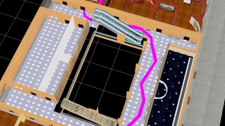
Wi-Fi monitoring requires the instalment of monitors which increases the costs. A key criterion is ‘localisation granularity’ (i.e. the frequency of localisation update). In the case of Wi-Fi monitoring , this is done every few minutes which is sufficient for guidance through a museum as visitors usually spend more than a few minutes in a particular room. Fingerprinting allows the exploitation of the Wi-Fi AP infrastructure already available without the need to install additional provisions. This results in lower implementation costs, while its accuracy is at the level of a few metres which is sufficient for museum guidance purposes. Its location granularity can be adjusted in line with the particular needs. In a museum there is no need to determine the exact coordinates of the visitor, but it is important to identify which room the visitor is in. Usually, both methods tested correctly determine which room the visitor is in. Our 3D path planning method made it possible to determine the route from the present location to a desired location within five seconds using the A* shortest path algorithm, which is a modified Dijkstra algorithm (Figure 1).
Looking Forwards and Back
This research was conducted within the framework of the Synthesis Project which is a part (seven weeks/10 ECTS) of the MSc in Geomatics at Delft University of Technology, The Netherlands. The project is aimed at integrating knowledge and skills gained during the first year by tackling a real-world problem as a team of students. The project gave us broad experience in working in a team as each student had to cover a predefined part of the research. This allowed us to develop our interpersonal skills while operating in a group. On top of that, we learned to manage a project, including approaching sponsors, budget planning, communicating with third parties and much more. The project resulted in two conference papers which also improved our writing skills, and we are proud to have contributed to research into indoor navigation. Our trip was rewarding and impressive as for most of us it was our first visit to China. We were inspire d by the support from, and the hospitality of, the researchers at Wuhan University. It was truly a great experience!
Further Reading
Report accessible through: http://www.tudelft.nl/fileadmin/Files/tudelft/studeren/master/Geomatics/Synthese_project/GEO2001_Final_Report_Final_Version.pdf
Lemmens, M., 2013, Indoor Positioning: Technologies, Features and Prospects, GIM International, 27:10, pp. 24-31.
Verbree, E., Zlatanova S., van Winden, K., van der Laan, E., Makri, A., Taizhou L, Haojun, A. (2013) To localise or to be localised with WiFi in the Hubei Museum?, ISPRS Int. Archives, Vol. XL-4/W4. pp.31–35, Cape Town, South Africa.
Xu, W., Kruminaite, M. Onrust, B., Liu, H., Xiong, Q., Zlatanova, S. (2013) A 3D model-based indoor navigation system for Hubei Provincial Museum, ISPRS Int. Archives, Vol. XL-4/W4. pp. 51-55, Cape Town, South Africa.
About the Authors
The authors, Eva van der Laan and Weilin Xu, are presently 2nd-year students on the MSc in Geomatics of the Built Environment at Delft University of Technology, The Netherlands. The curriculum was renewed in 2012 and now focuses on advanced technology for capturing, storing, analysing and disseminating geoinformation. The MSc attracts students from all over the world, including Lithuania, Greece and China.
Email: E.B.vanderLaan@student.tudelft.nl; W.Xu@student.tudelft.nl
Figure Captions
Figure 1, Path (pink line) from starting point (red dot) to the desired location.
Group photo:
The seven MSc geomatics students from Delft in front of the Hubei Museum, Wuhan. From left to right: Benny Onrust, Marija Kruminaite, Eva van der Laan, Haicheng Liu, Antigoni Makri, Karl van Winden and Weilin Xu.

Value staying current with geomatics?
Stay on the map with our expertly curated newsletters.
We provide educational insights, industry updates, and inspiring stories to help you learn, grow, and reach your full potential in your field. Don't miss out - subscribe today and ensure you're always informed, educated, and inspired.
Choose your newsletter(s)


