Heritage BIM on the Move
Point Cloud Management Strategies in Cultural Heritage Documentation
In a system termed 'historical BIM', building information modelling (BIM) is becoming a useful approach in the documentation and enhancement of historical structures. It is not easy to convert point clouds into a 3D model since the buildings concerned often have very irregular geometry. Therefore, more semi-automatic parameterisation tools are needed. Portable, user-navigable HBIM databases offer interesting potential to broaden the use of cultural heritage information, as this article shows.
Historical building information modelling (HBIM) can be defined as a semantic-aware database of historical buildings, in which the geometric model is connected to descriptive multi-source information. Historical buildings are usually examples of stratified artefacts with non-regular and complex geometry, unlike modern constructions which commonly have regular geometry. Reality-based spatial data from advanced geomatics 3D modelling techniques can provide an accurate reproduction of those buildings, with all the information connected, although the heterogeneous characterising shapes are a big challenge when modelling the geometry. Most of the time these shapes have to be remodelled manually, since effective automatic recognition is not yet sufficiently developed. The aims, structure and scale – and thus the expected level of detail of the model – greatly influence the approach to data acquisition (sensors, accuracy) as well as data processing.
Shape Modelling
Architectural shapes – surfaces (planes, curves or extrusion), volumes and complex objects – have to be recognised and segmented from the raw 3D data to be embedded in the HBIM. Geometric shape modelling is based on: 1) manually modelling volumes and shapes from scratch; 2) making cross sections and surface extrusion using semi-automatic procedures; and 3) automatically fitting primitives to the point clouds through feature extraction. The choice depends on the feasible level of parameterisation for each individual element.
The first step in the BIM structuring workflow is the modelling of shapes. The next step is the semantic modelling: recognition and categorisation of objects. The final step is the modelling of relationships between objects. One area of interest in the geomatics field is the availability of effective tools for the acquisition of suitably dense point clouds. Also high on the research agenda are processing algorithms for the geometric modelling and model segmentation, without the loss of non-metric information closely connected to the geometry of the artefact.
Besides the from-scratch shaping, an as-built point-cloud-based model could be made from several types of objects. Standard objects comparable to simple shapes (regular floors or walls) can be easily identifiable by algorithms implemented into modelling tools using commercial software. Complex objects (columns, frames, niches, mouldings, pilasters, stucco, roofs) require local modelling to define parametric rules from adapting constraints on metric data by processing the point cloud. When custom libraries are inadequate, local objects (irregular shells, vaults, ornaments) should be designed, making use of ad-hoc feature extraction and adaptive complex surfaces with B-rep algorithms or via non-uniform rational basis splines.
Valentino Castle
One example comes from a historical building in Turin, Italy: Valentino Castle, headquarters of the Architecture Department of Politecnico di Torino (see Figure 1). The HBIM model was conceived for the ground floor of the Hall of Columns. An integrated 3D survey was performed using Lidar and close-range photogrammetry. With the output, a historical model based on the optimised point cloud was calculated and parameterised. This point cloud has been segmented into architectural elements that have different shape-recognition difficulties. For example, the walls and floor were easily identifiable by fitting algorithms; the columns and frames could be modelled as parametric local families. However, since standard vault creation has not been effective in BIM platforms, creation of the vaults needed an ad-hoc modelling approach. This was realised by the extraction of the groins starting from cross sections of the vault surface. The final HBIM structure included all the architectural elements.
Portable Navigable Databases
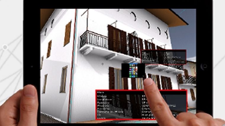
The 3D BIM models facilitate information sharing and ongoing updates. Moreover, BIM databases on portable devices offer very interesting potential for an applied use of models in the building conservation domain. A user-oriented model can be useful to analyse the building with the information ex-post (highly detailed model). It can also be utilised to create and adjust the building information model directly on site in real time during the conservation and restoration phase. That entails a less specific and more convenient model since a lower level of detail (LoD) is required. To optimise and pre-process for the desired LoD, it is necessary to differentiate and pre-determinate models from 3D surveys – for both the structure and the embedded information. Figure 2 shows a portable and navigable HBIM model of the town of Pollenzo (the ancient Roman city of Pollentia in northern Italy). After the 3D metric documentation by integrated terrestrial and aerial sensors, the model is navigable and queryable on a tablet, for instance.
The advantages of portability and the ease of information sharing encourage the use of HBIM models in a wider community. It is possible to generate models for specific applications including: museum installations and popularisation projects; for specialists in architecture, restoration and structural engineering; for 3D (city) GIS; and also for immersive virtual reality (VR) / augmented reality (AR) experiences.
(H)BIM Workflow and Tools
Building information modelling is an ‘intelligent’ approach in design workflow. Thanks to the additional information stored in the shared BIM database platform, it differs from common 3D modelling by facilitating multidimensional control. Today, the prefix ‘multi-’ means seven dimensions: 3D + time + cost + sustainability + facility management. Historical building information modelling can be defined as a semantic-aware database regarding historical buildings, in which the geometric model is connected to descriptive multi-source information.
The workflow for HBIM projects starts with data acquisition from various different sensors according to the context requirements and the expected outputs. Then, the surveyed point clouds have to be pre-processed and reduced with various systems and dedicated software, and perhaps adapted for segmentation using automatic or semi-automatic object recognition into a BIM platform. Furthermore, elements will be modelled and converted into an approximation of reality according to parametric rules, so it is possible to adapt each instance of the model. Finally, the shapes and the identities of objects must be linked by accurate and solid relationships according to the semantic definition of entities. From that moment, the model is ready to be explored with other information for analysis and monitoring over time. Nevertheless, the manual generation of 3D models connected to as-built BIM is complex and time-consuming. Since the costs and skills for processing the data mean that this approach is not sustainable, more automatic or semi-automatic tools for parameterisation of metric and non-metric information are needed.
BIM platforms offer dedicated embedded tools or plug-ins: 3D modellers, viewers, analysers. They assist in point cloud optimisation and processing in order to produce geometric modelling, feature extraction and parameterisation in heritage buildings. Some commercial ones include ArchiCad BIMx by Graphisoft, Scan-to-BIM by IMAGINiT, Revit by Autodesk, BIM360 by Autodesk, Recap by Autodesk, PonitSense by FARO, Leica CloudWorx, Green Spider, Bentley MicroStation V8i and Tekla Structures. Some open-source alternatives are Edificius, Tekla BIMsight and Autodesk Navisworks Freedom by IMAGINiT.
Further Reading
Murphy, M., McGovern, E., Pavia, S. (2013) Historic Building Information Modelling – Adding intelligence to laser and image-based surveys of European classical architecture, ISPRS Journal of Photogrammetry and Remote Sensing, Volume 76, February 2013, pages 89-102, ISSN 0924-2716, http://dx.doi.org/10.1016/j.isprsjprs.2012.11.006
Volk, R., Stengel, J., Schultmann, F. (2014) Building Information Models (BIM) for Existing Buildings – Literature review and future needs. Automation in Construction 38, pages 109-127, DOI: 10.1016/j.autcon.2013.10.023.
Del Giudice, M. and Osello, A., 2013. BIM for Cultural Heritage, CIPA Strasbourg: BIM for Cultural Heritage, The International Archives of the Photogrammetry, Remote Sensing and Spatial Information Sciences, XL-5/W2, pages 225-229.
Tang, P., Huber, D., Akinci, B., Lipman, R., & Lytle, A. (2010) Automatic reconstruction of as-built building information models from laser-scanned point clouds: A review of related techniques. Automation in Construction, 19(7), pages 829-843. DOI: 10.1016/j.autcon.2010.06.007

Value staying current with geomatics?
Stay on the map with our expertly curated newsletters.
We provide educational insights, industry updates, and inspiring stories to help you learn, grow, and reach your full potential in your field. Don't miss out - subscribe today and ensure you're always informed, educated, and inspired.
Choose your newsletter(s)


