High-resolution topography of a World Heritage cave
TLS and SfM survey of the Ochtiná Aragonite Karst Phenomenon in Slovakia
TLS and SfM photogrammetry have been used for the geodetic surveying and 3D mapping of the Ochtiná Aragonite Cave in Slovakia. This world-famous karst landscape of significant geological, geomorphological and mineralogical value represents a combined labyrinth consisting of parallel tectonically controlled halls and passages. The new detailed map, sections and 3D model create an innovative platform for a more detailed study of the morphology and genesis of this unusual cave, including for its environmental protection and use in tourism.
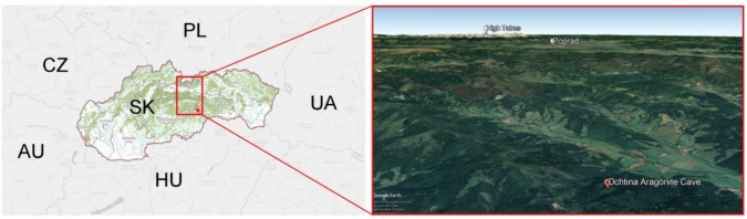
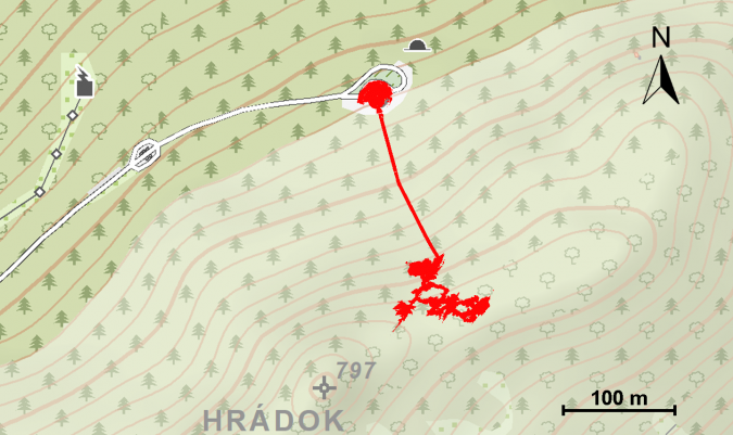
The Ochtiná Aragonite Cave is located on the north-western slope of Hrádok hill (809m) in the Revúcka vrchovina mountains in southern Slovakia (Figure 1). It was discovered accidentally during an excavation of the exploratory adit in 1954. Since 1995, it has been part of the Caves of Aggtelek Karst and Slovak Karst UNESCO World Heritage site. It is famous and significant not only for its rich and rare aragonite decoration, but also because of its specific morphologies. However, the complex morphology of this cave, especially of its medium-scale and small-scale morphologies, is not sufficiently visualized on the existing speleological maps.
Classic surveying and mapping of bedrock surfaces with such irregular and rugged morphologies is much more time-consuming and mostly less precise. For this reason, terrestrial laser scanning (TLS) and structure-from-motion (SfM) digital photogrammetry were used for the new geodetic surveying and 3D mapping of the cave.
High-resolution survey
Terrestrial laser scanning and SfM digital photogrammetry can be considered as a suitable technology for non-contact measurement of spatial coordinates, 3D modelling and visualization of complex underground structures. The high speed of surveying, accuracy, higher productivity versus common geodetic methods, significant shortening of fieldwork and automatic data processing into digital models make this technology almost irreplaceable in rapid speleological mapping. Another important advantage is the use of an own-source laser beam, which ensures hassle-free surveying in poorly illuminated or non-illuminated underground spaces.
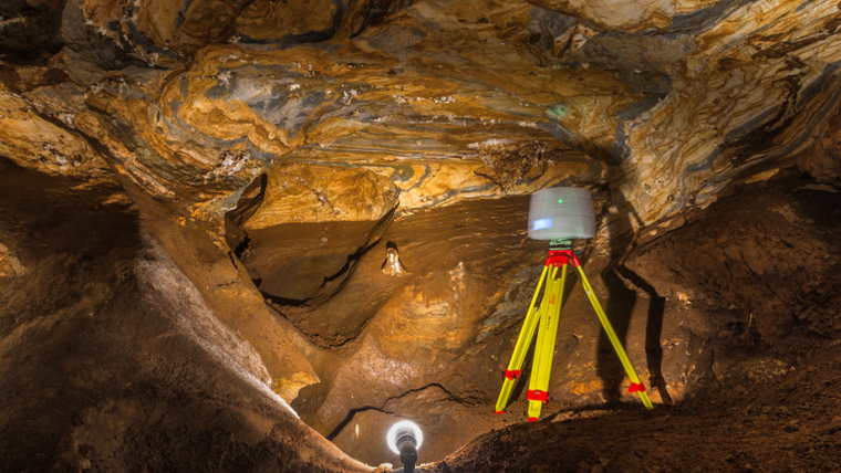
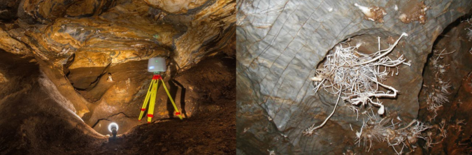
During the TLS survey, a Leica ScanStation C10 scanner (Figure 2) was used to scan cavities, ponds, tourist paths as well as aragonite decoration with high resolution and detail. Overall, more than 121 million points were measured using 54 survey stations. The horizontal and vertical resolution on the scanned surface was 20 × 20mm.
Additionally, the SfM method of digital close-range photogrammetry (one of the most advanced methods of processing photogrammetric images) was implemented to achieve high-resolution mapping of selected morphologic structures. As conventional photogrammetric methods require a set of identical points present on photographic images with their known spatial position, camera positions and scene geometry in the SfM method are reconstructed simultaneously based on the automatic identification of characteristic matching features.
All images were captured by a DSLR Pentax K-5 digital camera with a Pentax SMC DA 15mm lens. The appropriate illumination of the image surfaces was ensured by spotlights along the tourist path, so no additional lights were needed. However, due to the spotlights, individual camera stations had to be carefully chosen to avoid blocking the source of the light and creating shadows on the surface. In total, 62 images were captured, from which the final point cloud containing 23 million points was generated in Agisoft PhotoScan software.
Results
Based on the findings from the new TLS survey of the cave, its total surface area is 1,335m2. The cave volume is 4,424m3 and the circumferential surface of the cave body is 7,064 m2. The largely irregular and uneven circumferential surface of the cave body relates to numerous medium-scale and small-scale phreatic and epiphreatic morphologies.
In terms of gross morphology and ground plan pattern, the cave is composed of parallel tectonically controlled passages and halls that are interconnected by smaller transverse conduits of phreatic and epiphreatic morphology. There are numerous ceiling cupolas and smaller spherical cavities, a flat ceiling, inwardly inclined smooth facets and spongework-like hollows. The whole cave represents a labyrinth with a high degree of connectivity.
3D model of the cave
Computer graphics and IT advancements are increasingly creating new and better conditions for digital data processing. In this case, the triangulated irregular network (TIN) method was applied. It was not always possible to use all the scanned points with the original point density for the final surface modelling. Therefore, the density of points was reduced to a defined distance of 100mm between points to generate a homogeneously composed and reduced point cloud. This was used to create the final TIN model of the cave (Figure 3).
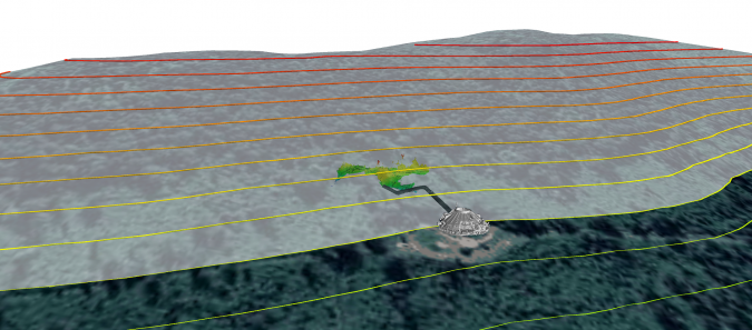
The spatial localization of the survey into the appropriate coordinate system and vertical datum enables the connection of the final 3D model with the surrounding digital terrain model (DTM) and accurate determination of its positional and vertical span (Figures 4 and 5). In addition, such a digital model can then be used to derive spatial relationships with the corresponding DTM (or another nearby underground structure) for further geo-exploration (geophysical surveys, civil engineering works, etc.). The 3D model illustrates that the Ochtiná Aragonite Cave consists of a striking linear passage formed along a steep fault, and a longer irregular spongework labyrinth of passages and halls.
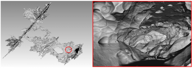
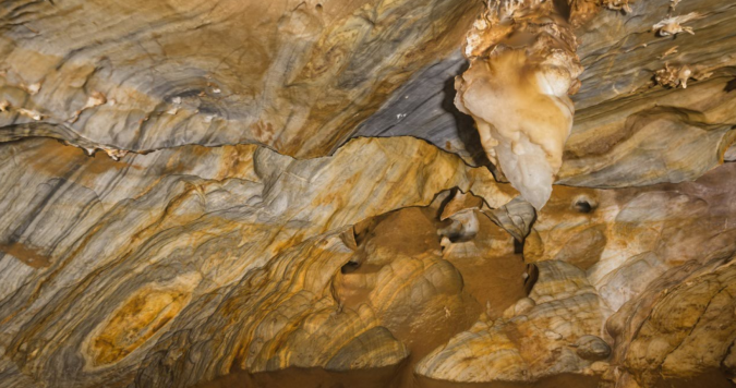
Additionally, some of the specific morphologies of the Ochtiná Aragonite Cave were imaged and photogrammetrically processed. A high-resolution 3D model of these different morphologies is necessary for a more detailed study of their origin (Figure 6).
The comparison of both technologies confirms that the significantly denser point cloud from photogrammetry provides a more detailed and smoother course of the model surface of the selected cave wall than the laser scan data. Additionally, laser scan data reveals more significant deviations at sharper edges and transitions, which is also the result of the lower density of the scanned data.
Conclusions
Surveying the Ochtiná Aragonite Cave using terrestrial laser scanning provided the most actual and precise map of this very remarkable cave. This map, in several sectors refined by surveying with digital photogrammetry, is an important tool for a more detailed study of cave morphology – including its structural and tectonic control, as well as medium-scale and small-scale solution forms. Moreover, terrestrial laser scanning made it possible to determine the basic surface and volumetric values of the cave.
Both technologies have specific requirements, advantages and disadvantages (in terms of accuracy, financial demands and practical issues when working – especially in narrow cave spaces and when illumination of the surface is necessary). Therefore, the combination of these methods has been shown as the most suitable for detailed mapping of complex cave spaces. It enables all of their specific features to be captured so that comprehensive data on the overall morphology can be created in the most accurate and detailed way.
Since the Ochtiná Aragonite Cave has opened to the public, the results of this new survey can now also be used to address some other issues related to human impact on the cave environment, such as microclimatic changes due to the movements of visitors in different parts of the cave and their negative influences on the fragile aragonite formations.
Further reading
Pukanská, K.; Bartoš, K.; Bella, P.; Gašinec, J.; Blistan, P.; Kovanič, Ľ. Surveying and High-Resolution Topography of the Ochtiná Aragonite Cave Based on TLS and Digital Photogrammetry. Appl. Sci. 2020, 10, 4633. https://doi.org/10.3390/app10134633
Multimedia
The point cloud from the TLS survey: http://ugkagis.fberg.tuke.sk/potree/ochtinska_aragonitova.html
Acknowledgements
This work was supported by the grants No. 1/0146/19 (VEGA) and No. 004TUKE-4/2019 (KEGA) funded by The Ministry of Education, Science, Research and Sport of the Slovak Republic. The authors would like to thank the Slovak Caves Administration for giving permission for 3D laser scanning, digital photogrammetry and geomorphological research in the Ochtiná Aragonite Cave.

Value staying current with geomatics?
Stay on the map with our expertly curated newsletters.
We provide educational insights, industry updates, and inspiring stories to help you learn, grow, and reach your full potential in your field. Don't miss out - subscribe today and ensure you're always informed, educated, and inspired.
Choose your newsletter(s)


