How 3D modelling supports game-changing urban development
The role of technology in making cities inclusive, safe, resilient and sustainable
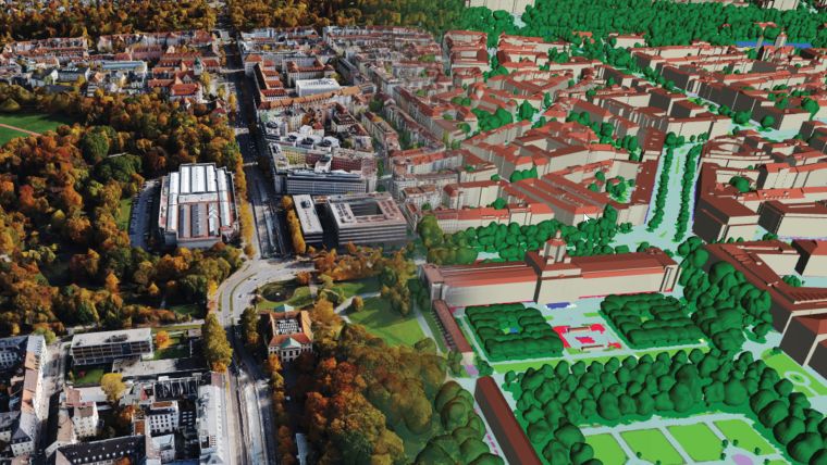
Accurate digital representations of cities are game changers in urban development. By enabling virtual modelling and smart simulations, they allow decision-makers to explore, test and assess the measures taken. Hosted on cloud-enabled platforms, these digital twins also facilitate collaboration among stakeholders who can jointly optimize for outcomes that make cities smarter, safer, more livable and more sustainable.
Adapting to climate change and mitigating its impact is essential for governments and local authorities. Such aspects are at the core of major city planning decisions around the world. By analysing 3D models and meshes, leaders can compare conditions within cities over time and simulate possible future scenarios. Having the ability to visualize development plans in 3D allows stakeholders to better understand the consequences of interventions, comprehend interrelationships and recognize planning errors at a pre-investment stage.
Professionals can also, for example, calculate the solar potential on rooftops, plan the optimal design of energy grids and critical infrastructure, and check urban vegetation for health. Green spaces in cities lessen the effects of pollution and alleviate the heat island effect which traps heat in urban areas. To preserve these crucial areas, trees can be modelled and monitored for health within 3D digital twins. Ensuring clearance from power lines and acknowledging changes in biomass can help detect diseases early and thus prevent the loss of vegetation. Communities can also use simulations to prepare for natural disasters such as floods and fires. The data and models help in identifying risk areas and planning evacuations.
Cities as agents of positive change
“Cities can be massive agents of positive change, if they are well-planned, built and governed,” the UN’s New Urban Agenda emphasizes. More and more people live in cities, and developing cities responsibly will be a major factor in helping overcome global societal and environmental challenges. To become such agents of change and to achieve the UN’s Sustainable Development Goals (SDGs) – i.e. to make cities inclusive, safe, resilient and sustainable – city administrations must make informed decisions based on accurate data. Combining Lidar and photogrammetry can provide such crucial data to drive sustainable transformation.
Users must be aware that merely image-based 3D models – even densely matched ones – have significant data gaps. Imaging data is hard to capture in narrow, occluded areas between buildings, shadow areas or under trees and can deliver dissatisfying results for smooth surfaces such as water or untextured roads. Introducing a second data source significantly improves the accuracy and quality of 3D models and meshes.
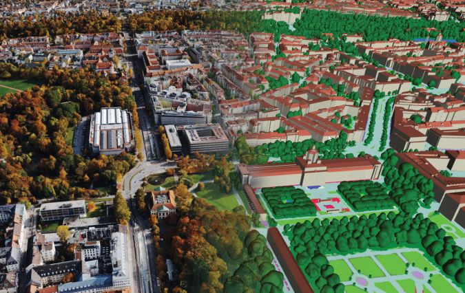
One of the big technological advancements in 3D technology is hybrid data, and specifically the simultaneous capture of images and Lidar point clouds. Optical images have high point accuracy in the X/Y plane, while Lidar has high accuracy in the Z component. Lidar adds accuracy to mesh models as it penetrates foliage and detects objects in shadowed areas between buildings, whereas optical data provides clarity for top-surface models where four-colour images are preferred for interpretation. Digital twins based on hybrid data, such as the ones created by the Leica CityMapper-2 hybrid airborne sensor, contain greater detail and consistency. As a result, they are ideal training data sources for standardized, accurate, large-volume analytics, feature extraction and machine learning.
Integrating high-performance workflow software will produce a variety of deliverables from the imagery and Lidar datasets, such as referenced images, orthophotos and colourised point clouds. When teamed with comprehensive geographic information system (GIS) and building information modelling (BIM) data, the real world can be converted into an exact digital replica to facilitate analysis, planning and management.
3D city models creating sustainable cities
Due to the range of applications, cities worldwide are already putting 3D city modelling into practice. The city of St. Gallen in Switzerland collaborated with architectural firm GSI Architekten, the World Wildlife Fund (WWF) and Hexagon to create a digital twin of the city. Accurate 3D city models created with the Leica CityMapper-2 airborne mapping system helped urban planners and architects to identify suitable areas for green belts and fresh-air corridors.
Demand for such 3D data and models has risen steadily in recent years. Even entire countries are using digital twins for sustainable development. In the Netherlands, the nation’s 3DNL digital twin is hosted on HxDR, Hexagon’s cloud-based visualization and collaboration platform for geospatial data and services. 3DNL includes features such as mesh measurements, asset management and sun and shadow analysis that enable solar-capacity calculations and high-rise simulations as well as building cross-section analysis.
From protecting the precious green spaces in our cities to improving the safety of the streets we walk through, new technologies on the market can point cities around the world in the right direction to accomplish the SDGs by 2030.

Value staying current with geomatics?
Stay on the map with our expertly curated newsletters.
We provide educational insights, industry updates, and inspiring stories to help you learn, grow, and reach your full potential in your field. Don't miss out - subscribe today and ensure you're always informed, educated, and inspired.
Choose your newsletter(s)


