How India Leverages Geospatial Technologies for Urban Management
Key Insights from India’s National Urban Programmes and Use Cases
This article explores how some government initiatives in India are utilizing geospatial technologies for better outcomes. The rapid pace of urbanization in India has been an instrument of socioeconomic, political and cultural progress, but has also thrown in multiple challenges. Recognizing the need for efficient management of urban spaces, the government of India has responded with robust measures and programmes that leverage geospatial and other information technologies.
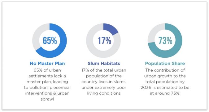
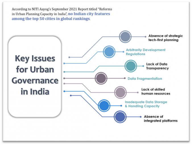
India’s inevitable transition in the 21st century from a predominantly rural society to a thriving urban society is beset with multiple challenges. These include heavy pressure on public utilities, poverty, unemployment and social evils (Figure 1). In its ‘Reforms in Urban Planning Capacity in India’ report published in September 2021, the NITI Aayog – India’s apex public policy think tank – highlighted that no Indian city features among the top 50 cities in global rankings.
Key Issues for Urban Governance in India
Data fragmentation, obsolete and arbitrarily updated development control regulations as well as inadequate involvement of innovators and experts at the grassroots level is to blame. Added to these factors is the deficit of human resource capacity at the lowest rungs of urban governance, where the actual fieldwork has to take place. Interestingly, such challenges are also behind the visible push for sustainable infrastructure development in the country, steering world-class urban systems with geospatial technologies as the keystone.
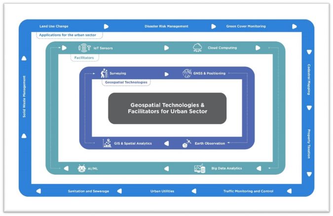
Applications of Geospatial Technologies in Indian Urban-sector Programmes
The government of India is keenly liberalizing geospatial data collection and distribution in the country, and has drawn up a number of proposals including the Geospatial Guidelines, Draft Geospatial Policy, Drone Rules and Remote Sensing Policy. These conducive steps are helping to unleash the technology’s true potential and giving the geospatial sector a much-needed boost. Several national initiatives within the urban domain that are leveraging geospatial technologies in India are outlined below.
1) Smart Cities Mission
Launched in 2015, the Smart Cities Mission (SCM) aims to promote sustainable and inclusive cities that provide core infrastructure and give a decent quality of life to citizens, a clean and sustainable environment, and the application of smart solutions in a hundred cities.
Geospatial Applications
- Proposed preparation of 40-layer GIS mapping of all cities.
- Smartnet knowledge-sharing platform launched for exchange between cities, practitioners, academia, researchers and technologists.
- Integrated Command and Control Centres (ICCCs) rolled out across 75 cities and to be set up in all 100 smart cities by 2022. Several ICCCs were transformed into COVID-19 war rooms to deal with the pandemic response.
- Information on food distribution centres, shelter homes and kitchens collated and made accessible via Google Maps.
- A Geospatial Management Information System (GMIS) – a ‘smart cities dashboard’ – containing data of 100 cities and 6,000 projects was launched to collate information from varied sources, compare performance between cities, monitor progress and predict project milestones.
- India Urban Observatory: a GIS-enabled interactive showcase of multi-parameter city insights. Data is collected through Internet of Things (IoT), APIs, open-source databases, sensors and third-party sources including citizens and social media.
- National Urban Digital Mission (NUDM) was launched in February 2021 with an array of digital infrastructure and tools for smart cities, including:
- Smart Cities Open Data Portal (SCODP): Single-point data-sharing platform for open datasets enabling smart city stakeholders to generate actionable insights.
- Smart Code: To serve the software development demand of cities developing data and solutions for various urban problems.
- India Urban Data Exchange (IUDX): Easy-to-adopt open-source platform based on an underlying framework of open-standard APIs, data models, security, privacy and accounting mechanisms.
- Urban Platform for delivery of Online Governance (UPYOG): Aimed at helping municipal bodies improve service delivery mechanisms, information management and participative governance initiatives.
- Urban Outcomes Framework 2022: Aimed at developing a transparent and comprehensive database based on cross-city outcomes for time-series analysis and progress tracking.
2) Atal Mission for Rejuvenation and Urban Transformation (AMRUT)
Launched in 2015, the AMRUT mission focuses on 11 reforms and 52 milestones to be implemented by 500 mission cities in different states. The five focus areas of the mission are:
- Water supply
- Sewerage facilities and septage management
- Stormwater drains to reduce flooding
- Pedestrian, non-motorized and public transport facilities, and parking spaces
- Enhancing the amenity value of cities by cleaning and upgrading green spaces, parks and recreation centres, especially for children.
Geospatial Applications
- Sub-scheme of preparation of masterplan using GIS launched with three major components: geospatial database generation, masterplan formulation and capacity building.
- Urban geodatabase to be created at a scale of 1:4,000. Final geodatabase of 104 towns and draft geodatabase for 104 towns prepared up until 2020/21.
- Sub-Scheme of Local Area Planning & Town Planning Scheme was launched on a pilot basis for 25 cities, involving detailed area survey, mapping of physical and social infrastructure on a GIS platform, land use mapping and GPR (ground penetrating radar)
- AMRUT 2.0 proposes GIS-based masterplans for Class-II towns with populations of 50,000-99,999.
- Capacity building at three levels.
3) Swachh Bharat Mission (SBM)/Clean India Mission
Launched in 2014, Phase 1 of the Clean India Mission lasted until October 2019, while Phase 2 is being implemented until 2025 to help cement the work of Phase 1. The mission is aimed at achieving an ‘open-defecation free’ (ODF) India through the construction of toilets. The second phase of the mission aims to sustain the open-defecation-free status and improve the management of solid and liquid waste, while also working to improve the lives of sanitation workers.
Geospatial Applications
- Bharat Maps (India Maps) – a multi-scale, multi-resolution, multi-layer GIS platform built on a service-oriented framework by National Informatics Centre (NIC) launched to integrate API-based OGC-compliant (WMS, WFS, etc.) map services with governance workflows associated with flagship government programmes, including SBM.
- Self-attested geotagged photographs being used for final verification of constructed household toilets, along with the applicant. Photographs are uploaded to SBM (Urban) MIS and monitored by urban local bodies (ULBs) and states.
- A partnership between the Ministry of Housing and Urban Affairs (MoHUA), the government of India and Google to map all public/community toilets on Google maps including unique IDs.
- Compendium and dynamic GIS portal launched by MoHUA showcasing innovative practices for effective solid waste management (SWM) practices from across India.
- Cleanliness surveys entirely integrated with GIS in 2021 with two distinct components of data collection through mobile app and monitoring of the complete project progress.
4) Pradhan Mantri Awas Yojana (PMAY)/Prime Minister Housing Scheme
Launched in 2015, this scheme aims to provide affordable housing for first-time homeowners. The target is to build 20 million ‘pucca homes’ (solid or permanent dwellings) with basic amenities like gas, electricity and water by 2022.
Geospatial Applications
- Bhuvan-MoHUA Web Geoportal was developed to monitor the progress of the beneficiary houses at five different stages under the scheme.
- PMAY (Urban) Management Information System integrated with BHUVAN Portal of NRSC and BHARAT MAP of NIC for monitoring the construction progress of individual houses through geotagging.
- Geotagging of photographs depicting the completed stage of construction used to deploy Direct Benefit Transfers to beneficiaries of the beneficiary-led construction vertical of the mission by states/union territories.
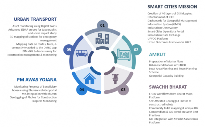
5) Urban Transportation
The National Urban Transport Policy (2006) and Metro Rail Policy (2017) have given impetus for states to develop integrated urban mobility options for citizens. As a result, many cities are working on metro rail projects. As of January 2021, India had 760.62 kilometres of operational metro lines and 540 stations. A further 1,016 km of metro and rapid rail transport systems are under construction in 27 cities.
Geospatial Applications
• A digital twin with an asset management system implemented by Maharashtra Metro Rail Corporation Ltd to eliminate information loss over the project lifecycle. Location of each of the 500,000 assets recorded to enable single-click viewing on a map, leading to estimated savings of INR 1,658 crore (approx. US$2 million) over 25 years of operation of the metro rail system.
• Advanced mapping completed by Kochi Metro Rail Limited (KMRL) using Lidar and bathymetric surveys to study social impact assessment and water quality for canal regeneration project.
• 3D mapping of all stations undertaken by the Delhi Metro Rail Corporation (DMRC) to combat terror threats in the Delhi metro.
• DMRC and Google Maps collaborate to add metro routes, fares, platform details and connectivity information on the platform for passenger convenience.
• DMRC uses Revit and building information modelling (BIM) supported by drone surveys for generating accurate topographic maps with orthophotos, base maps and volumetric analysis to manage construction and assets.
Insights and Way Forward
Together with a conducive policy regime, the government of India’s active adoption of geospatial technologies across urban governance programmes is significantly boosting the adoption of technology in the country. Urban stakeholders now need to ensure that the vision of a sustainable urban machinery is suitably backed by geospatial technologies from the bottom up. The need of the hour is a connected quality data ecosystem with efficient outcomes – one that is continually updated and shared with contributions from the industry, researchers and civil society. Urban officers need to be oriented on the larger value of geospatial technologies in both the short and long term. Efforts are also needed towards the capacity development of urban professionals across levels to ensure better understanding, adoption, integration and implementation of geospatial technologies. Rather than being viewed in isolation, geospatial applications need to be seen as a fundamental layer upon which to build key solutions. The industry must step forward and act as hand-holding agencies towards this vision.
Further Reading
Role of Geospatial Technologies for Urban Affairs in India, Association of Geospatial Industries, India, August 2022: https://agiindia.com/industry-reports/
Overview of Urban Report by Mr Pramod Kaushik, president of AGI and MD of Hexagon India https://youtu.be/H3SLcwPn0DU
Address by Mr Mahendar Singh Tanwar, IAS, Municipal Commissioner, Ghaziabad Municipal Corporation: https://youtu.be/-brRGLr3g_w
Panel discussion on overcoming critical urbanization challenges with geospatial solutions: https://youtu.be/ZI7iK4EwDs0
Other recordings from AGI India Urban Meet (4 August 2022) – Why geospatial is fundamental to urban initiatives; from data to ecosystem approach: https://youtube.com/playlist?list=PLJZgK8nZr6CaKz83ncWwS8Z4v3D_s-p51

Value staying current with geomatics?
Stay on the map with our expertly curated newsletters.
We provide educational insights, industry updates, and inspiring stories to help you learn, grow, and reach your full potential in your field. Don't miss out - subscribe today and ensure you're always informed, educated, and inspired.
Choose your newsletter(s)


