How Lidar Has Changed the Way to View Michigan's Terrain
Staff from the Michigan Department of Environment, Great Lakes, and Energy (EGLE) in the USA are using Lidar technology to view the topography (elevation) of the state at a resolution that is 50 times greater than previously existed. "In fact, Lidar has fundamentally changed how we view and interpret the landscape," says John Esch, geology specialist. "Often, subtle features can be seen in the high-resolution Lidar topography data that are not visible on aerial photography, topographic maps and in some cases right under our feet."
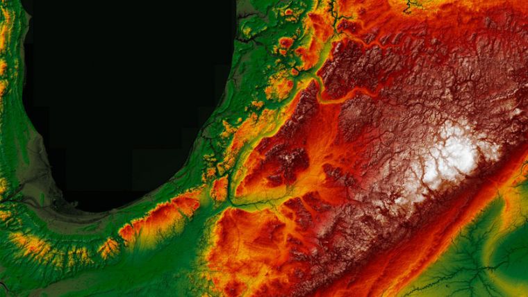
Lidar emits an intense, focused beam of light at the ground and measures the time it takes for the reflected pulses to be detected by a sensor. This produces a densely spaced network of highly accurate georeferenced elevation points as a point cloud with a point spacing of approximately 60cm.
Digital Elevation Models and Point Clouds
These elevation points are classified by what the Lidar pulse was reflected from (ground, vegetation, water, buildings or other objects). The ground elevation points are used to produce highly accurate digital elevation models (DEMs) that can be used to generate three-dimensional representations of the Earth’s surface and its features, with elevation accuracies that are approximately 10cm. An intensity map of the returned Lidar pulse is produced, and common Lidar products include DEM hillshade, slope, digital surface models, shaded relief, elevation contours and automated building extraction.
These DEMs and point clouds can be useful in a variety of settings. Not only have they been used to assist in mapping wetlands, floodplains and watersheds, but also in mapping coastal and inland dunes, coastal erosion, sinkholes and in investigation of contamination sites. Many subtle features, especially geologic features, can only be seen using the Lidar data.
The benefits of Lidar data collection
Lidar has revolutionized how EGLE staff and others view Michigan's topography, hydrology, geology and land use. This better understanding of the landscape will result in better decisions across state government and will benefit the citizens of the state. Lidar data collection is funded from a variety of state and federal sources and is publicly available. About 80% of Michigan has been scanned by Lidar, with the remainder of the state to be scanned this year.
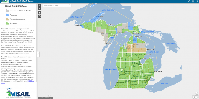
The State of Michigan is known as a leader in technology use, and has an innovative imagery strategy. This is best proved by The Michigan Imagery Solution (MIS), a cloud-hosted repository of imagery that’s fed by the Michigan Statewide Authoritative Imagery & Lidar (MiSAIL) programme, which captures fresh imagery and elevation data for the state on a five-year revolving basis.
Since 2014, FEMA (Federal Emergency Management Agency) and USDA/NRCS (US Department of Agriculture, Natural Resource Conservation Service) have invested over US$4.8 million to acquire and deliver standard Lidar products for 60 Michigan counties using the MiSAIL programme.
For more information about Lidar mapping progress in Michigan, see here.
Acknowledgement: The source of the cover image of this news article is MAS Context, a quarterly journal created by MAS Studio, addresses issues that affect the urban context.

Value staying current with geomatics?
Stay on the map with our expertly curated newsletters.
We provide educational insights, industry updates, and inspiring stories to help you learn, grow, and reach your full potential in your field. Don't miss out - subscribe today and ensure you're always informed, educated, and inspired.
Choose your newsletter(s)


