HRIS and a Trillion Trees
Need for High-resolution Geospatial Information for Forest Resource Planning
Precision forestry technology is moving forward at an amazing pace, with advancements in global positioning systems, remote sensing platforms and data sources, cloud geospatial engines, mobile GIS data collectors and advanced selective logging machinery. Without accurate and reliable vegetation inventory information, however, this new arsenal of precision forestry tools falls short for operational forestry. Not knowing exactly where and how a specific tree stock is growing in the landscape makes it very difficult to selectively log or plant that resource for inventory supply management or, as more and more groups are exploring, to plant more of it to enhance our atmospheric carbon sinks. High-resolution inventory solutions (HRIS) are now making it possible to account for and measure growth dynamics of Earth's trillions of trees.
New research on global forest cover potential indicates that planting trees by the billions could be one of the most cost-effective ways to significantly reduce atmospheric carbon levels and help combat climate change. In practice this makes a lot of sense; trees sequester carbon from the atmosphere and store it in their stems and in the ground. However, there are many complex growth-process logistics to consider when contemplating planting new forests, and many variables to consider when quantifying and managing their carbon storage potential. How fast will the trees grow in a given location? What kind of forest community and structure fosters or hinders tree growth? How will climate change affect their growth potential? And what forces might slow them down or drive mortality before they reach their full carbon sequestration potential? These are difficult questions to answer at local, regional and global scales.
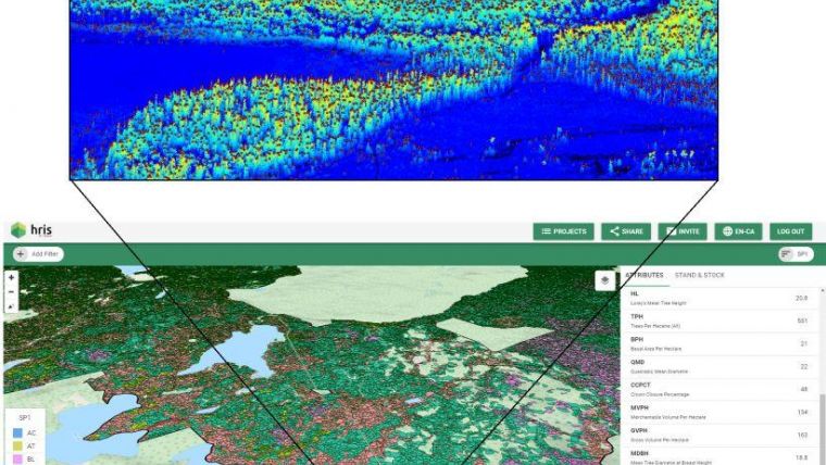
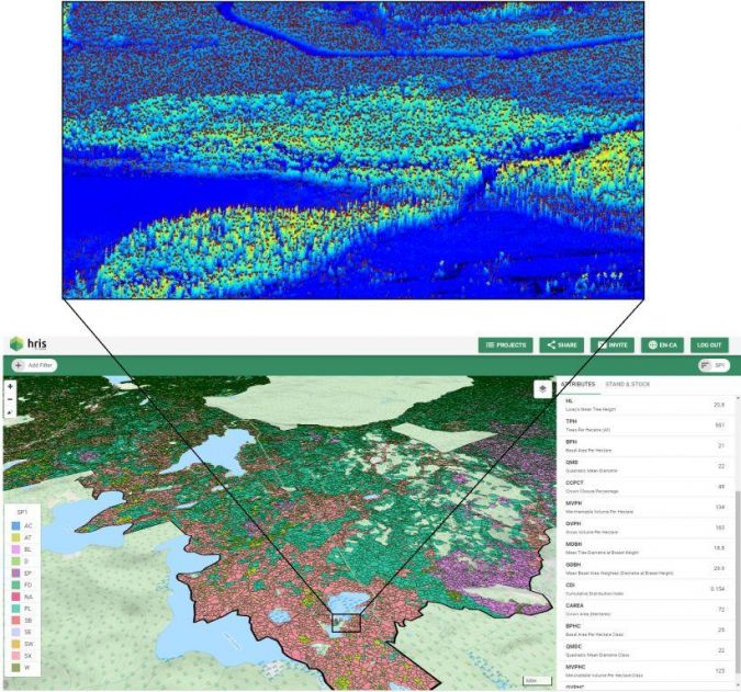
New technology advancements in very-high-resolution remote sensing and geospatial analytics are emerging that now allow foresters, silviculturists and data scientists to account for and measure growth dynamics for the trillions of trees on the planet (current estimates put the global tree count at 3.04 trillion) as part of sustainable natural resource management solutions. For example, faced with the challenge of creating highly accurate inventories for millions of hectares of forest managed in British Columbia, Canada, Tesera Systems created its high-resolution inventory solutions (HRIS). Based on advanced geospatial data fusion and processing methods, the resulting high-resolution inventory product combines detailed stand biometric information from ground plots, high-density airborne Lidar, multispectral aerial and/or satellite imaging, and a suite of climate, topographic and hydrological indicators. This enables generation of statistically verifiable accuracy and precision forest attribute estimates at the microstand level (0.2-5 ha). Moreover, it produces estimates of growth and yield potential for any given stand of trees in a landscape.
The HRIS viewer helps foresters utilize this massive amount of data by putting detailed and reliable information about their changing forest resources at their fingertips. This powerful web GIS portal enables them to navigate and spatially query millions of high-resolution inventory attributes generated from the stand biometric geospatial models. The stand productivity index that incorporates climate metrics, actual tree growth and yield observations allows foresters and land managers to make short/medium/long-term plans. Hence, they can better align their operations with carbon storage targets, for example, or with regulatory guidelines for forestry-specific climate mitigation strategies.
Forest landscapes can change significantly from year to year due to natural disturbance dynamics such as fire, floods, disease and human activities. As forest inventory solutions continue to leverage higher-resolution and higher-frequency satellite radar and multispectral imagery sources, along with machine learning techniques to automatically update and improve the inventory dynamics models, such solutions have the capacity to scale across vast areas (i.e. millions of hectares) and offer ongoing updates to changes in forest resources. Forest managers need access to reliable, detailed and dynamic forest stand and stock databases in order to successfully target their reforestation efforts and assess deforestation impacts. Such information also helps regulators to gauge local and regional changes in forest inventory in the context of global carbon cycles and major climate mitigation initiatives.
Humanity tends to disagree on plans of action for large global problems when the data is uncertain, missing or outdated. With reliable tree inventory information in the hands of decision-makers and workers on the ground we can move forward with sound plans and actions to mitigate losses and reduce risks in the forestry sector with respect to climate change. If we take it upon ourselves as a global society to plant a trillion trees to increase global carbon sequestration, it surely would be invaluable to track how those plantations are performing and how much carbon they are storing. Using highly accurate geospatial data from sources such as Tesera’s high-resolution inventory technology, we can more confidently plan, manage and adapt to the changing needs for forestry resources, not only considering timber and wood/pulp products, but also other ecosystem values including global carbon restocking and storage needs.
Further Reading

Value staying current with geomatics?
Stay on the map with our expertly curated newsletters.
We provide educational insights, industry updates, and inspiring stories to help you learn, grow, and reach your full potential in your field. Don't miss out - subscribe today and ensure you're always informed, educated, and inspired.
Choose your newsletter(s)


