Increasing Information in Building Models
New Technology Can Significantly Improve BIM
Since the advent of building information modelling (BIM) software in the early 2000s, 3D modelling has significantly improved building design. With regular updates, BIM can also ensure that, during construction, the work progresses according to the design. In practice, however, BIM usually stops once construction starts. This can mostly be attributed to the complexity and cost of gathering accurate and current data needed to update the digital models. The German firm NavVis GmbH is a Munich-based start-up that has developed technology which overcomes these barriers by reducing the cost and increasing the efficiency of capturing and comparing data of physical structures to design models. This innovation has the potential to significantly increase the scope and efficiency gains of BIM.
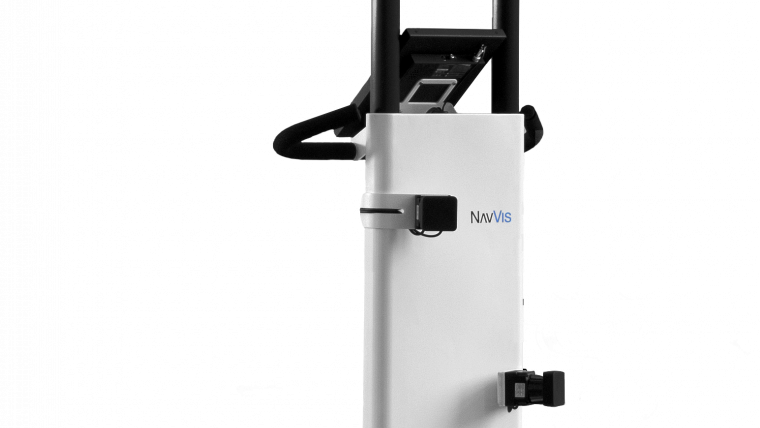
Capturing data for building models of existing structures is a time-consuming process that requires a high level of skill. The data is typically collected by a professional surveyor using a static tripod-mounted laser scanner. To improve this process, NavVis developed the 3D Mapping Trolley, a 3D scanning and mapping tool that significantly increases the speed and efficiency of capturing indoor data (Figure 1). The trolley is equipped with three lasers, six cameras and several antennas, and it automatically captures every inch of space in 3D as it is moved around. The measurements captured generate point clouds (Figure 2) that are later also used to create the navigation graphs that enable indoor routing. The photographs captured are subsequently processed by NavVis software to create panoramic images. This process requires nothing more than an operator pushing the trolley through the space to be captured. The NavVis M3 Trolley is equipped with a touchscreen that provides real-time feedback to show which areas have been scanned, making it easy to identify areas that still need to be mapped.
3D visualisation software
Of course, digital building data is only valuable if it is accessible to the people who need to work with it. For this reason, NavVis developed browser-based software, known as IndoorViewer, which displays 3D visualisations of the data captured by the M3 Trolley. Crucially, the IndoorViewer software automatically generates the 3D visualisation, eliminating the need for specialised software. The 3D images can be viewed and navigated from any device, much like Google StreetView. IndoorViewer, however, has more functionality than Google StreetView; for example, it displays coloured 5mm-resolution point clouds that can be used to measure distances between individual points and the navigation graph also enables routing. There are a number of other useful features, such as being able to add detailed descriptions of objects in the scene.
BIM enhancement
The automated scanning and mapping enabled by NavVis technology both supports and enhances traditional building information models. Currently, BIM is most often used in the design phase of a building project, but the construction phase is equally important if the design is to be implemented according to plan. The M3 Trolley can be used as a data-capturing tool to update and compare BIM models on a regular basis. Once the data has been captured there are two options for comparing the models: 1) With a virtual walkthrough in IndoorViewer which gives a detailed view of progress and eliminates the time and cost of travelling to the site; 2) By comparing point clouds in IndoorViewer and using colours to detect differences. Red is used for large differences and yellow for smaller ones (Figure 3). Based on this information, construction timetables and building models can be adapted accordingly and damage or non-adherence to the plan is detected much sooner.
The IndoorViewer software also enhances the building modelling process. The BIM database can be connected to IndoorViewer and specific details can be ‘dropped’ into the software and made available through the ‘point of interest’ feature. This means that anyone involved in the building design and construction team can easily access this information. Unlike BIM software IndoorViewer does not require specialised training, plus it can be accessed from a tablet or smartphone. Hence, after processing, the information is also available on site.
Using the photographs in IndoorViewer also significantly improves the quality of the data available in the BIM model by providing a much more detailed overview of an indoor space than is obtained with scanning only. Users are able to zoom in on the high-resolution panoramic images. This enables details about specific materials used to be added to the BIM model (Figure 4) by checking IndoorViewer, without having to visit the site after the initial scanning has been done.
After the project is completed, the 3D construction documentation gathered in this way can be used to fully digitise building operations and facility management. The IndoorViewer software provides building owners and operators with a virtual database of building assets (Figure 5) that can be tracked and monitored remotely. Additional information can be added to specific points and objects with a mouse click, which is especially useful for cataloguing building inventory. To protect the built asset, the 3D documentation can be used in insurance claims while the routing information can be used to reduce emergency response time. The routing option also optimises internal logistics, both for employees and external partners who can deliver shipments and provide services to a precise location. Building operators can even create and assign maintenance tickets with high-resolution imagery and an exact location reference.
Shaping the future of buildings
As the benefits of building models continue to gain recognition, the adoption of BIM will continue to grow. Many national governments – including of the USA, Germany and the UK – have already acknowledged the value of BIM and have begun to mandate digital modelling in the design phase of large construction projects. The evolution of BIM through NavVis technology increases the scope for deriving benefits from digital modelling, effectively paving the way for BIM to become even more valuable (Figure 6).
About the author
Hannah Szwarc is an account manager for Germany at NavVis GmbH. She specialises in providing NavVis customers with next-generation building information modelling and computer-aided design solutions. She has also driven the NavVis Emergency Response Pilot Project, which enables significantly faster and more efficient responses to indoor emergencies in buildings digitised by NavVis technology. Hannah holds both a BSc and an MSc in technology and management from the Technical University of Munich (TUM).

Value staying current with geomatics?
Stay on the map with our expertly curated newsletters.
We provide educational insights, industry updates, and inspiring stories to help you learn, grow, and reach your full potential in your field. Don't miss out - subscribe today and ensure you're always informed, educated, and inspired.
Choose your newsletter(s)


