Indoor Risk Management
A Spatially Enabled Online Tool for Monitoring Workplace Safety
Risk management of power plants, dry docks and many other workplaces is aimed at ensuring the health and safety of workers as well as the people living in the vicinity. A spatially enabled risk management system supports staff safety by reducing or even eliminating incidents. Here, the author describes an online tool which has been developed in the Philippines and has been filed for a patent.
In the workplace, faulty wiring may cause a fire, slippery floors may cause workers to fall, and poorly shielded equipment may result in injured limbs. National labour and employment organisations all over the world have the statutory duty to protect workers, to promote and advocate injury prevention, and to enforce regulations. Therefore, the focus should be on the avoidance of incidents; this requires regular inspections to detect deficiencies of facilities, equipment and machinery. A management information system is a valuable tool in helping to avoid incidents, to act adequately if they do occur and to lessen the risk of them recurring. But such a tool also requires locational data about workplace facilities, equipment and machinery since georeferenced data enables the right measures and actions to be taken. The Environment, Health, Safety, and Security (EHSS) intelligent solution developed in the Philippines is such a spatially enabled risk management tool.
EHSS
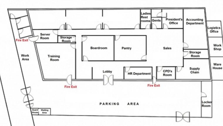
Any spatially enabled risk management tool relies on storage and processing of locational data on facilities, equipment and machinery in the form of 2D or 3D coordinates. This can be done in a local database, but a national reference system is preferable. EHSS stores locational and attribute data in a relational database management system (RDBMS). The locational data is input interactively on a pre-loaded map. Developed as a web application, it uses the RDBMS MySQL in concert with PHP, a server-side HTML embedded scripting language designed for web development. It allows the identification, notification, recording, investigation, analysis, assessment, correction and control of risks and hazards in the mapped workplace. To keep the data up to date, continuous auditing and measuring through workplace surveys are required. On the resulting base map (see Figure 1) the locations of incidents and hazards can be mapped allowing analysis of the cause and providing insight into how to avoid future events.
Continue reading in the online edition of GIM International.

Value staying current with geomatics?
Stay on the map with our expertly curated newsletters.
We provide educational insights, industry updates, and inspiring stories to help you learn, grow, and reach your full potential in your field. Don't miss out - subscribe today and ensure you're always informed, educated, and inspired.
Choose your newsletter(s)


