Key Global and Technology Drivers Impacting Surveying
Reflections by the FIG Commission Chairs
As the FIG commission chairs near the halfway point in their terms, they reflect on the global and technological drivers influencing their work. This article describes the breadth of work across the FIG commissions as well as the common areas. The discussion is also informed by global reports such as the UN-GGIM’s Future Trends in Geospatial Information Management and the RICS Futures Report 2020.
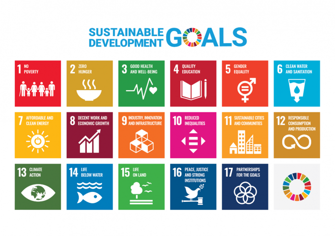
A major global driver for FIG is the ‘2030 Agenda for Sustainable Development’ and the association is committed to supporting the UN member nations in meeting the 17 Sustainable Development Goals (SDGs) and 169 targets. Key global challenges include climate change, natural and other disasters, urbanization and food and water insecurity. Climate change increases the risk of natural disasters leading to displacement of people, environmental impacts and economic losses. It also impacts food and water security, making access to arable land and drinking water a global challenge. Mitigation and adaptation strategies are a key focus for spatial planning and development and cadastre and land management. Positioning and measurement as well as spatial information management play a role in improving data accuracy, data modelling and reporting against SDG 13 (Climate action), SDG 14 (Life below water) and SDG 15 (Life on land).
Global drivers
Urbanization is an important driver of the global development agenda, posing significant challenges for governments. Approximately 15% of the world’s population live in urban informal settlements and slums lacking access to safe water, sanitation and other needs (Satterthwaite and Mitlin 2014). Pro-poor spatial planning and development as well as land administration (relevant for the Cadastre and Land Management commission) systems are needed to support sustainable development and land markets and to enhance the urban/rural interface.
Participatory cadastre and land management combined with spatial planning and development supports responses to SDG 1 (No poverty), SDG 2 (Zero hunger), SDG 5 (Gender equality) and SDG 11 (Sustainable cities and communities) aiming for equal land rights for all. These issues are evident in global land governance frameworks such as the Voluntary Guidelines on the Responsible Governance of Tenure of Land, Fisheries and Forests in the Context of National Food Security (CFS and FAO, 2012).
The Valuation and the Management of Real Estate as well as Construction Economics and Management commissions provide expert information to the market to support decisions on managing scarce resources. Environmental, social and governance (ESG) thinking in response to the SDG targets supports construction project initiation, engineering surveys, procurement, carbon accounting and environmental resilience.
Professional standards and practices underpin these responses and support SDG 16 (Peace, justice and strong institutions) and SDG 5 (Gender equality) through professional ethics and standards. Professional education supports SDG 4 targets related to equal access to education, increased participation and literacy levels, and ensuring that all learners acquire the knowledge and skills needed to promote sustainable development. The surveying education curriculum needs to keep abreast of the current global challenges, as well as the advances in technology and new approaches of the profession. Professional education also has a role in preparing graduates who can develop mechanisms and processes that will help to meet those needs. Advances in ICT and learning management systems mean that professional education can be more accessible than ever before.
COVID-19 restrictions since 2020 have impacted the way of working, space requirements and consumer demand. There is also a rising demand for geospatial information and more rapid adoption of technology. Global construction will be critical in the economic recovery, and spatial planning and development, cadastre and land management, valuation and the management of real estate, hydrography, engineering surveys, and construction economics and management will all play an important role. This will not be possible without effective positioning and measurement and spatial information management, underpinned by professional standards and practice and professional education.
Technological drivers
Looking ahead to a post-COVID world, the key technological drivers are likely to include smart cities, BIM, digital twins, autonomous surveying techniques, artificial intelligence (AI), machine learning and big data, blockchain, augmented reality, automated feature extraction and change detection. While these are having a big impact in the Global North, they also are driving advancement in the Global South.
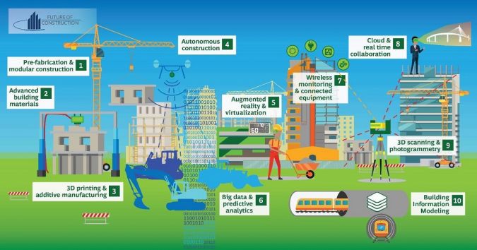
Smart cities, BIM and digital twins
Smart cities provide solutions to urbanization problems through better managing complex surroundings creating opportunities for smart technologies and efficient governance models (UN-GGIM, 2015). BIM, GIS, smart cities and digital twins all require precise positioning and measurement of the buildings and critical infrastructure ensuring better integration into smart city design. The construction economics and management notion of ‘whole-life thinking’ is being applied to construction and infrastructure projects, connecting building operations, asset management and construction into integrated management and information frameworks.
Artificial intelligence, machine learning, big data and cloud computing
The Internet of Things and information processing technologies support intelligent sensing and machine learning processes across a range of devices (UN-GGIM, 2015). The amount of data collected brings challenges for data management and is driving developments in spatial information management and positioning and measurement, including big data, cloud computing, AI and machine learning, that allow the data to be processed more efficiently (UN-GGIM, 2020). While these technologies bring huge benefits, they also result in privacy (RICS, 2020) and digital divide challenges, with professional standards and practice becoming ever-more important.
Augmented reality
Augmented reality (AR) approaches involve adding digital elements to a live view, often by using technology such as the camera on a smartphone. This provides interesting opportunities for spatial information management and positioning and measurement. The implementation of AR can also facilitate assessment to provide data for land registration and spatial planning decision-making, cadastral and engineering surveys and hydrography.
Automated feature extraction and change detection
Automated feature extraction (AFE) tools can help spatial information management in the extraction of geospatial features in large datasets, allowing object detection for change detection purposes. These tools can be used for a range of applications including feature extraction of parcels to support cadastre and land management, and automation of the identification of parties (e.g. landholders).
Autonomous surveying techniques
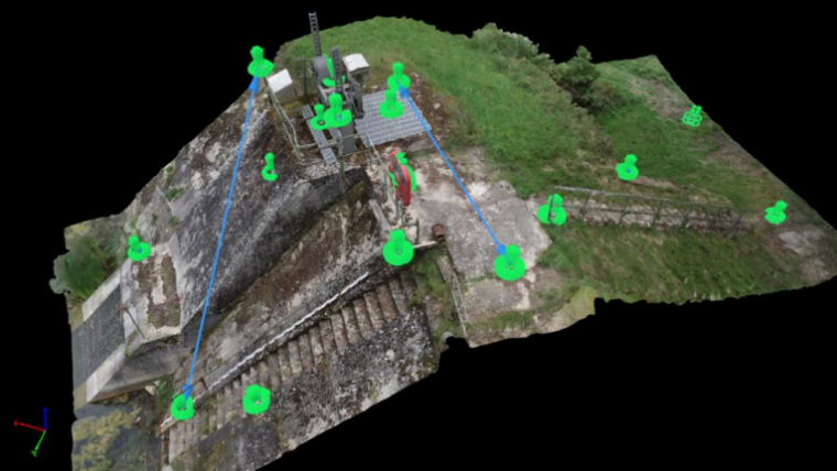
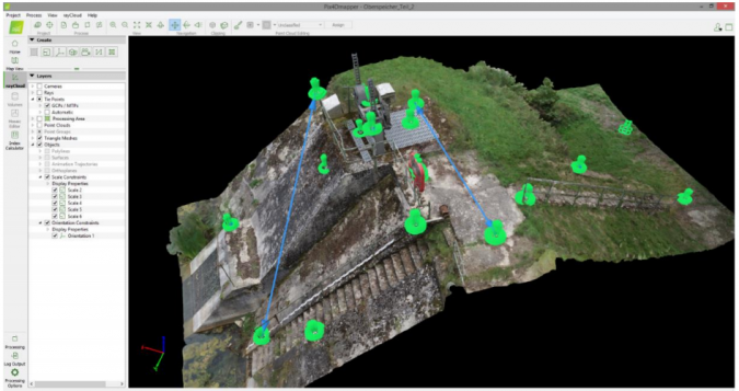
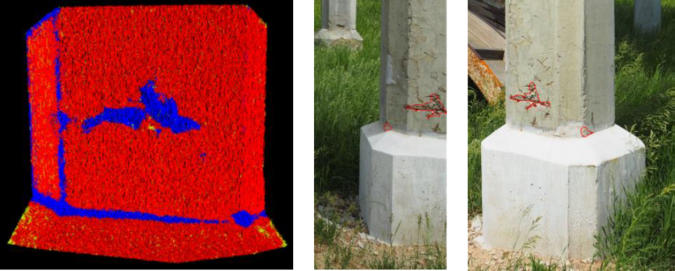
Autonomous surveying techniques can be used in cadastral surveys, hydrography and engineering surveys for construction and monitoring purposes. Autonomous vehicles for aerial, maritime and terrestrial surveys provide a cost-effective tool that is easily deployed for monitoring infrastructure. Having an accurate reference frame helps positioning and measurement work undertaken for engineering surveys to be linked to data from diverse sources.
Blockchain
Blockchain technology and tools introduced into cadastre and land management and the valuation and the management of real estate can bring certainty and clarity to investment decisions, making them simpler and faster. By linking existing title and valuation documents and other forms of information with property data from AI and machine learning, blockchain provides more transparent digital data and more data points.
More accessible geospatial information
Spatial planning and development views the world as land-use layers, within the landscape and its use. New geospatial technologies, AI, big data and cloud computing all make it easier to perform complex analysis to support decisions. Accurate and accessible geospatial information is at the heart of the inclusive decision-making necessary for sustainable urban development, especially for SDG 11 (Dijkstra et al, 2010).
Rise of new data sources and analytical methods
New positioning and measurement techniques are primarily based on GNSS technology but include various means of reducing collection times (RTN) or providing augmented signals from ground- based or space-based augmentation systems (GBAS/SBAS). Remote sensing is now accomplished from drones much more cost-effectively than from satellites. Thanks to cost-effective positioning and measurement through cheaper GNSS receivers and the fusion of data from multiple sensors and techniques, more users can accurately access geospatial data. This broadens and strengthens spatial information management and enables crowdsourcing to support the assessment of progress against the SDG targets.
Fusion of data from different sensors
To develop smart cities, geospatial information must be integrated into the evolving architecture, standards and best practices. Every sensor and device connected to the internet has location information that sets the context for the information transmitted. Geospatial information becomes particularly important when the sensor or device is moving (UN-GGIM, 2020). In terms of positioning and measurement, geospatial coordinates can be provided by SBAS, GBAS, imagery, Lidar, IMUs and/or total stations, offering benefits beyond simply GNSS. Use of GNSS helps to orient all the different sensor data into a common reference frame for ease of combining the data. Moreover, new instruments allow cadastral and engineering surveys to be undertaken very close to the object or from afar, including aerial or subterranean and underwater environments. Fusion of datasets offers many alternative ways for obtaining geospatial coordinates in difficult circumstances and gives a more complete status of the object being studied in real or near-real time.
Crowdsourcing and volunteered geographic information systems
One response to the increased demand for geospatial information is crowdsourcing and volunteered geographic information (VGI) systems to complement existing data. The sheer volume of crowdsourced geospatial data makes up for its lack of accuracy. This data can ‘learn’ and ‘adapt to’ changes in the environment, such as when traffic flows are detoured based on data crowdsourced from GPS users. While individual observations of geospatial coordinates might be inaccurate using handheld GNSS, statistical distribution will eventually reveal an accurate estimate of the true value. Positioning and measurement can help to ensure correct datums, and spatial information and management ensures that standards are applied to ensure metadata and programming consistency exists in the crowdsourced data.
Conclusions
The geospatial profession needs to continually evolve to respond to global challenges, social impacts and the rapid evolution of technology. The drivers mentioned in this article are having a profound impact on this work. It is important to ensure that the professional standards and practices, including the valuation, construction and other global standards the industry operates under, are still relevant. It is also essential that the next generation of professionals are educated and competent and able to contribute responsibly to the global challenges.
Further reading
Dijkstra, P., Schroten, K., Emens, S., and Lemmen, C., (2020) Ten Years to Go to Achieve the Sustainable Development Goals, GIM International.
Muse (2012) Construction economics is fundamental in responding to coronavirus
RICS (2020) RICS Futures Report 2020, London.
Roman (2020) Positioning the World for the Future
Satterthwaite, D. and Mitlin, D. (2014) Urban Poverty in the Global South: Scale and Nature, London: Routledge.
UN-GGIM (2015) Future Trends in geospatial information management: the five to ten year vision, Second Edition, James Norris, Ordnance Survey, August 2015.
UN-GGIM (2020) Future Trends in geospatial information management: the five to ten year vision, Third Edition, August 2020.
Varner, Herbst, and David Schmidhuber (2020) A Toolset for Automating 1mm Measurement Accuracy in Photogrammetry Surveys, FIG Working Week 2020 proceedings, 10-14 May 2020.
Hadavandsiri and Lichti (2020) Concrete Damage Detection based on Machine Learning Classification of Terrestrial Laser Scanner Point Clouds, FIG Working Week 2020 proceedings, 10-14 May 2020.
About FIG
The International Federation of Surveyors (FIG) is the premier international organization representing the interests of surveyors worldwide. It is a federation of the national member associations and covers the whole range of professional fields within the global surveying, geomatics, geodesy and geoinformation community. It provides an international forum for discussion and development aiming to promote professional practice and standards. For more details, see https://fig.net/about/index.asp.

Value staying current with geomatics?
Stay on the map with our expertly curated newsletters.
We provide educational insights, industry updates, and inspiring stories to help you learn, grow, and reach your full potential in your field. Don't miss out - subscribe today and ensure you're always informed, educated, and inspired.
Choose your newsletter(s)


