LAS and LASUtility
Lidar Data File Format and Freeware
Light Detection and Ranging, or Lidar technology has become an industry-standard high-speed tool for collecting dense and accurate topographic data. However, proprietary or ASCII file formats for storing Lidar data limit the scope of data sharing and result in time-consuming data processing and loss of integrity. Instead, the industry recommends an American Society of Photogrammetry and Remote Sensing standard data exchange format, Lidar Standard or LAS, which requires dedicated processing software. Existing image-processing and GIS software are being updated to include LAS, but so slowly that some users are converting their data from LAS to more convenient formats. We have filled the gap with the free software tool ‘LASUtility’.<P>
LAS Genesis
In the early days of Lidar, vendors used industry-proprietary or ASCII file formats, which caused problems. Data in proprietary file format cannot be moved easily from one system to another. Data in ASCII file format degrade in performance as their reading and processing slows, and file sizes increase, even for a small area. Furthermore, raw data and information specific to the Lidar data can be lost, restricting data problem troubleshooting and debugging and resulting in loss of data integrity.
An industry-wide, acceptable binary data format was thus needed to deliver, exchange, analyse and manipulate Lidar data between data providers and users. Industry leaders, working under the tutelage of ASPRS, have developed a standard, publicly available Lidar data exchange format called LAS (with the extension .las). This format is intended to overcome the problems of propriety and ASCII file formats and maintain information specific to Lidar data while keeping the data simple. LAS Lidar data have now been accepted by Lidar vendors and are widely available to users.
New Versions
The first released version of LAS file format, 1.0, contains binary data consisting of header block, variable length records, and point data. All data are in little-endian format. The header block consists of a public block followed by variable length records. The public block contains generic data such as point numbers and coordinate bounds. The variable-length records contain variable types of data, including projection information, metadata, and user-application data. The second version of LAS file, 1.1, retains the same structure as the first, but with changes in interpretation and alignment of a few fields. New fields have been added to make it more suitable for applications. LAS file formats version 1.2 and 2.0 have recently been proposed. Version 1.2 would retain the same structure as version 1.1, while including GPS absolute time. The RGB could also be specified with each point data, an influence stemming from the terrestrial laser-scanning industry. Version 2.0 would include extensive changes to version 1.1, such as extending the format to include terrestrial scanners.
Drawbacks
The LAS format is not yet a part of several GIS, image-processing, DEM, and point-cloud processing packages commonly used for Lidar data processing . Dedicated Lidar software that read, convert or process LAS file format are expensive. Neither is any user-friendly software tool available at present that can permit study of a LAS file by displaying its entire content.
LASUtility
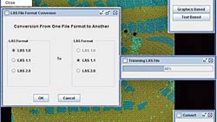
The authors therefore developed a software system to help the Lidar community in these transitional times. The result, LASUtility, offers the following capabilities for working with LAS files:
-
viewing interactive textual display of LAS file content (header records and point-cloud data)
-
viewing graphical display of LAS file point-cloud
-
trimming an LAS file based on graphically selected area of interest or range of point data records
-
stitching/combining several LAS files of same format in one large LAS file
-
conversion between/within different LAS file formats
-
conversion of LAS file into ASCII file with XYZ and/or intensity
-
conversion of XYZ, intensity, and return number stored in text file into equivalent LAS file
-
- converting entire contents of LAS file into text file.
This software is designed to help those wishing to use existent GIS or other in-house software for processing LAS files without investing in dedicated Lidar processing software. Many users worldwide have already downloaded the software from the website (Figure 2), which has a rich graphical user interface that facilitates use. LASUtility was developed using JAVA programming language, ensuring platform independence. The software includes a help file and is updated frequently to keep pace with the changes in LAS file formats and user feedback.
Available as from 16thDecember 2008 at wesbite 1.
Further Reading
- ASPRS LIDAR Data Exchange Format Standard, Version 1.0, May 9, 2003.
- LAS Specification Version 1, March 07, 2005.
- LAS Specification Version 1.2 April 29, 2008.
- INCITS L1 ASPRS LAS standard DRAFT version 2.0, August 17, 2007.
- Lewis Graham, ASPRS Lidar Committee, the LAS 1.1 Standard, July 2005.

Value staying current with geomatics?
Stay on the map with our expertly curated newsletters.
We provide educational insights, industry updates, and inspiring stories to help you learn, grow, and reach your full potential in your field. Don't miss out - subscribe today and ensure you're always informed, educated, and inspired.
Choose your newsletter(s)


