Laser Scanner and Drone Capture 3D Point Clouds for Military Heritage Restoration Project
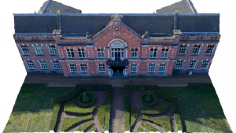
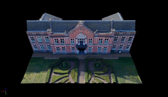
In conjunction with Eyefly, Dutch surveying company Geomaat has produced a complete 3D model of the exterior, interior and roof of the Emma building at the Johan Willem Friso Kazerne, a former military site in Assen, the Netherlands. The result is a unique ‘total solution’ for Rijksvastgoedbedrijf, the country’s Central Government Real Estate Agency. Several techniques have been cleverly combined to create a complete 3D point cloud, mesh and Revit model.
The Emma Kazerne building – a former barracks built in neo-renaissance style – is an important part of the Johan Willem Friso Kazerne military site in Assen because of both its cultural heritage and its architectural value.
The Emma Kazerne building is therefore being authentically restored to its former glory. The restoration of the listed building, which has been a defining feature of the Assen skyline for many decades, must meet very exacting standards in order to preserve or recreate all the historic details. In view of the complexity of the building, the client wanted to record and analyse the entire property in 3D.
Benefits of collaboration
The first stage of this pilot project was to scan the entire building using a static laser scanner, both inside – from the ground floor all the way up to the roof construction – and out. Geomaat then worked together with its sister company Eyefly to capture the top of the building using a drone. These surveys produced two 3D point clouds – with a relative accuracy of 5mm from the static laser scanner and less than 10mm from the drone – which were combined into a single 3D point cloud.
The point cloud was then converted into a Revit model to enable the client to work with the new design in Revit up to Level of Detail (LOD) 300.
Thanks to Eyefly’s 100MP camera, it was possible to create a 3D mesh of the whole building. The 3D mesh is a true-colour 3D model of the real-life situation, created from hundreds of 100MP photos. The mesh has a resolution of approx. 1mm per pixel. In other words, each pixel in the 3D mesh shows 1mm of reality. This level of detail enables any damage to be analysed in advance. It also gives a stunning representation of the real-life situation.

Value staying current with geomatics?
Stay on the map with our expertly curated newsletters.
We provide educational insights, industry updates, and inspiring stories to help you learn, grow, and reach your full potential in your field. Don't miss out - subscribe today and ensure you're always informed, educated, and inspired.
Choose your newsletter(s)


