Lidar-based Mobile Mapping for Accurate Documentation of Work Zones along Transportation Corridors
Mobility of people and goods plays an important role in providing economic and social opportunities and benefits. Improving the efficiency and safety of transportation corridors is critical for realising such benefits. Therefore, maintaining and expanding such infrastructure are among the key priorities of federal and state transportation agencies. Mobile mapping systems equipped with Lidar units can rapidly collect spatial data in work zone areas without affecting traffic.
The availability of digital maps with road characteristics such as lane marking, lane width, signage, curvature and grade is crucial for driver assistance systems, road safety evaluation, risk assessment, traffic accident reduction and infrastructure monitoring. The United States Federal Highway Administration (FHWA) reported that 47,758 injuries occurred in work zone crashes during 2013 (FHWA, 2017). Efficient work zone monitoring and inspection plays a critical role in decreasing traffic accidents and congestion. Lane width and geometry evaluation are important aspects of road safety inspection of work zones. For example, a narrow lane will increase the probability of severe accidents. Narrow shoulders, presence of guardrails, poor signage, short tapers, encroaching construction barrels and/or confusing lane markings can further exacerbate traffic congestion in work zones.
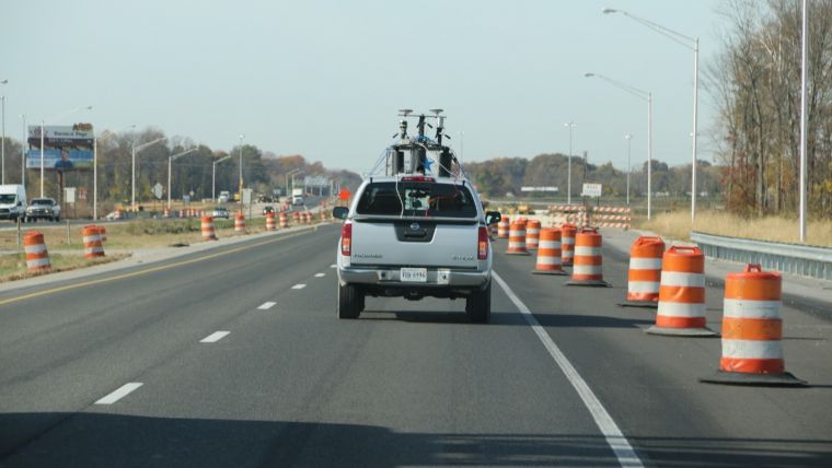
Mobile mapping systems (MMSs) equipped with light detection and ranging (Lidar) units can rapidly collect spatial data in work zone areas without affecting traffic (Figure 1). Geometric and semantic road characteristics can then be derived from the acquired point cloud and images for risk assessment. Acquired Lidar data by wheel-based MMSs can be used for deriving lane width values as well as other characteristics (e.g. shoulder width, signage clearance, construction barrel alignment and encroachment, invisible lane markers, improper lane markers and potential debris/rubble on shoulders). These capabilities can be even enhanced by integrating Lidar data with digital images captured by the MMS.
Integrated global navigation satellite systems and inertial navigation systems (GNSSs/INSs) with laser scanning/ranging units can derive accurate point clouds with high point density along the driven corridors. In addition to the spatial coordinates of the laser beam footprints, the system also provides intensity data that represents the reflectivity of the scanned objects in the waveband associated with the Lidar unit. The intensity data for transportation arteries is quite useful when compared with other Lidar mapping projects (airborne mapping) due to the high reflectivity of several features along the road network such as lane markers, guiding/warning signage, construction barrels, etc. (Figure 2). The geometric accuracy and the intensity of acquired point clouds can be used to automatically extract several features such as lane markers, which can be then used to derive the lane width. Lane capacity in terms of vehicles per lane per hour depends on the lane width, shoulder width and truck volume. A short road segment with substandard lane width will significantly reduce the lane capacity (Figure 3). MMSs equipped with Lidar units provide a safe and accurate modality for accurate estimation of lane width without affecting the traffic, especially in work zones where great care should be exercised to enhance traffic flow.

Value staying current with geomatics?
Stay on the map with our expertly curated newsletters.
We provide educational insights, industry updates, and inspiring stories to help you learn, grow, and reach your full potential in your field. Don't miss out - subscribe today and ensure you're always informed, educated, and inspired.
Choose your newsletter(s)


