Lidar Data Capture: Where Are We Now?
Lidar provides an excellent way for mapping applications such as distribution utility services, as-built surveys of mines and roads, vegetation risk management and forestry services. In this article Tim Hustwayte, senior client manager at NM Group, answers the most frequently asked questions regarding the latest Lidar developments and describes how to achieve the best possible project outcome.
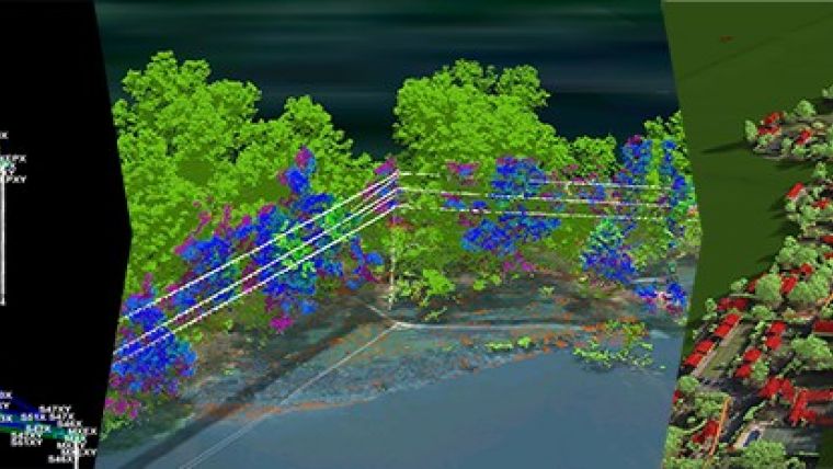
Aren’t 3D visualisation platforms doing the same thing as the corporate GIS?
A key part of our service delivery, particularly for vegetation management, is to provide a 3D view of the lines, ground and trees along with reporting and measurement tools. However, we’re often challenged and asked something like ‘How does this differ from our GIS?’ It is a great question – and a fair one. We see the corporate (or enterprise) GIS as representing a single source of truth on the position and attributes of network assets. The data that makes it into this system is subject to robust validation and is updating procedures and a range of governance rules. It is a core part of the utility information infrastructure alongside the asset management system.
The type of system we provide has been designed to complement this GIS capability and deal with things that aren’t practical for the enterprise system. We deal with data that has a very time-limited value – the position of the conductors at the time of survey and the current state of the trees. This information would have no place in the GIS yet it is crucial to vegetation managers. The requirement to rapidly provide this information to utility users (often as quickly as a few days after data capture) also means that ingesting it to a corporate system will be highly resource intensive, or even impossible. Finally, we’ve geared this platform to run over the web and take hundreds of gigabytes of mass Lidar data. It can’t do what the GIS can, but it can stream the virtual representation of the 3D world.
Is Geiger-mode/single-photon Lidar going to replace linear Lidar?
Geiger-mode or single-photon Lidar has been made available to the commercial market recently. These technologies use a different approach to measuring the returning photons to acquire dense Lidar data from higher altitudes, giving real benefits in terms of efficient coverage and consistent datasets across the project area. Trade-offs can include more limiting weather windows, the need to fly at night (in some cases) and the higher degree of noise in the data compared to waveform Lidar.
These technologies can have real value for a utility in terms of consistent network coverage at a high resolution – whether commissioned directly or as a spin-off to a separate acquisition campaign by a third party (say for a country or state-wide programme). The mass coverage is particularly useful for highly dispersed distribution assets, for updating pole positions, for defining geographic connectivity and for calculating vegetation clearances, for example.
So will it replace linear Lidar? Probably not. We see it as another tool in the utility toolbox, to complement Lidar and imaging from fixed and rotary-wing aircraft. The different sensors and flight regimes, combined with the size and layout of the network, capture and delivery timescales and budget, will all come into play. For example, it isn’t likely to be a practical tool for annual revisit for vegetation mapping in early leaf-on conditions and won’t necessarily come with high-resolution imagery.
What is the typical turnaround time to process Lidar data for a utility?
The simplest answer is that there is no typical turnaround time! In some cases we will provide data within one week of acquisition where rapid access to the data is needed (say in a post-storm assessment) and in other cases (such as modelling 10,000 miles of network in PLS-CADD) this will be carried out over a year. Some of the variables at play will include the complexity of the product set, the degree of manual data cleaning, the quality of the source GIS/asset information and the size and shape of the network. Also important, where quicker turnaround is required, is time to adequately plan flight logistics and test and refine any workflows and deliverable products well before capture commencement.
In general, most things are possible – from three weeks post-flight for a vegetation report through to six months for a new line design. What makes either possible is adequate time to plan, test and evaluate – meaning a collaborative approach to procurement with knowledge of the risks and constraints to timelines.
How can we achieve more value from our geospatial data/Lidar project?
Getting more value in this context means finding more than one use for data and models, ideally so that other costs are offset or processes made more efficient within the utility. Fortunately, transmission and distribution projects based on remote sensing from aerial platforms offer significant scope. Ideally, this is something that is considered in the planning phase so that the specification considers the value options, rather than something that is reviewed once a project is underway. Areas where extra value can be found include:
Specify data so it is available to multiple users. For example, if you are acquiring data for use in an engineering model it can likely be adapted to report on vegetation infringements for use by vegetation management users. It may also be used to update the asset register, providing up-to-date structure locations and property boundaries for asset management or real estate.
Find data capture synergies. In many cases utilities will fly helicopter patrols for close-up asset inspection sorties, such as spotting pole defects. Often a Lidar mission is also flown later in the year for monitoring vegetation compliance. Using the latest technology it is possible to combine the two projects in one flight and reduce the OPEX burden.
Share the data widely. Another area to consider is how will the data be used and distributed around the business to ensure the full benefit of the information is realised? Going 3D provides an option, but also consider data feeds that automatically update corporate GIS or management systems to ensure data is updated regularly.
Can Phodar do the same thing as Lidar for my vegetation scoping project?
We were intrigued when we first saw the term ‘Phodar’. It isn’t a term common in remote-sensing parlance, such as Lidar or radar. So while it may be that the term Phodar is clever marketing spin (combining photo detection and ranging), it is important to note that there is also some established science behind it.
Phodar uses photogrammetric techniques to acquire a 3D measurement of the real world. This technique is actually the driving force behind much 3D city mapping/modelling. The primary drawbacks of the technique in a powerline context are that it cannot penetrate vegetation to the ground, it can’t provide information on the structure of the tree (say for volume calculation) and it cannot reliably measure conductors.
The implication is that the technique is only really suitable where a quality 3D model of the powerline exists and where only simple top-down vegetation encroachments are needed. On the positive side, the lower cost of the equipment and the highly automated process mean it will have a place where financial drivers are stronger.
In conclusion, Phodar is something that has merit but also has significant drawbacks for powerline asset data collection.
Tim Hustwayte is senior client manager at NM Group. NM Group is specialised in the provision of custom services in surveying and mapping, asset modelling and management, and engineering. The company has over 135 staff members from a range of specialities including electrical & mechanical engineering, geospatial, aviation and surveying. NM Group is operating worldwide.

Value staying current with geomatics?
Stay on the map with our expertly curated newsletters.
We provide educational insights, industry updates, and inspiring stories to help you learn, grow, and reach your full potential in your field. Don't miss out - subscribe today and ensure you're always informed, educated, and inspired.
Choose your newsletter(s)


