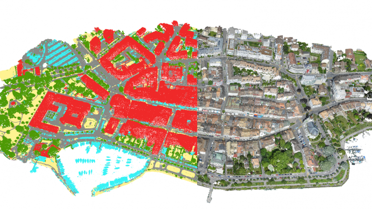
Machine-learning Point Cloud Classification
Pix4Dmapper is an industrial-standard photogrammetry software package that provides accurate 3D reconstruction from overlapping images. Along with the expanding drone market, people are keen to explore new solutions to replace or to complete traditional technologies. Point cloud classification, an iconic feature for Lidar point cloud, is now also being considered by drone surveying professionals.
While Lidar provides up to four returns and gives precise and clean 3D points, the quality of photogrammetry points is based mostly on image content. It is more challenging to classify photogrammetry point cloud than the Lidar point cloud. However, with the advancement of platforms and sensors, image quality has been largely improved and so has the photogrammetry outputs.
In Pix4Dmapper 4.0, you will be able to automatically classify their point clouds into several groups, such as buildings, vegetation, roads, human-made objects and ground. The classifier was developed based on supervised machine-learning technology. This also means that the more datasets being labelled, the better our classifier will be. The results can be further corrected or improved by using the point cloud editing tool. This feature will also play an important role in software development, allowing better handling of buildings and different objects in orthomosaic and 3D photogrammetry point cloud.
The point cloud classification opens up much more applications, such as detecting the vegetation growth, precisely removing above-ground objects to obtain an accurate digital terrain model and giving more accurate measurement for analysis.
Prevent electricity outage by vegetation control
Vegetation is one of the leading causes of power line outages. It is extremely important for energy companies to keep track of vegetation growth to be able to trim it down before it causes any damage.
With the high-definition point cloud Pix4Dmapper generates, you could already inspect the power lines from all aspects in the rayCloud interface, and with the classification, those extracted infrastructures can be grouped and digitised for more detailed analysis.
Disregard vegetations on top of a stockpile
One of the applications of extracting the bare-earth terrain from a digital surface model is to obtain precise measurement. By separating the vegetation or other human-made objects on top, the calculated stockpile volumes become more reliable.

Value staying current with geomatics?
Stay on the map with our expertly curated newsletters.
We provide educational insights, industry updates, and inspiring stories to help you learn, grow, and reach your full potential in your field. Don't miss out - subscribe today and ensure you're always informed, educated, and inspired.
Choose your newsletter(s)


