Mapping a Landslide Using UAS
A New Low-altitude Survey Technology
An Unmanned Aerial System (UAS) was used to acquire images of a small area in Italy for the purpose of post-landslide monitoring. The entire chain from aerial survey up to the automatic generation of maps and contour lines could be conducted within two days – one day surveying and one day processing – thanks to the use of sophisticated photogrammetric software. The quality of the final products is comparable with those achieved using conventional photogrammetry, while the throughput is faster.
After occurrence of a landslide, reliable, accurate and timely data is required in order to enable authorities to take proper measures. In the southern Italian municipality of Vibo Valentia (Calabria) located in the massif of Monte Poro, five areas are at high risk of landslides due to severe hydrogeological instability (Figure 1). Although these areas are rather small, the impact of landslides on infrastructure and urban centres may be large. The relatively large size of 1.43km² of the Vibo Valentia landslide area, where the height differences reach over 250m, and its proximity to the city triggered the authorities to carry out a survey after the occurrence of a landslide. The authorities chose Unmanned Aerial System (UAS) technology as they recognised its time-saving and cost-efficiency benefits.
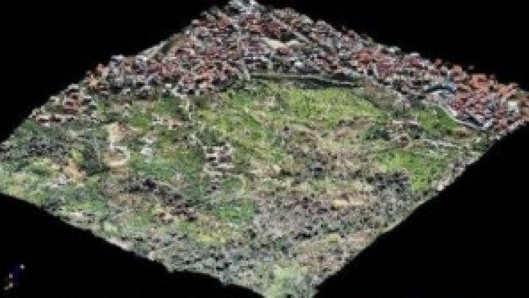
| 3D representation: orthomosaic draped over DSM. |
UASs are piloted remotely. Depending on the sensor types on board, UASs allow monitoring of urban areas, archaeological sites and other areas. Since data processing can be carried out highly automatically, the use of a UAS enables quick and cost-effective multi-temporal analysis of small areas. In the Vibo Valentia project, a Swinglet CAM was used. This lightweight fixed-wing drone weighs 500g and has a flight endurance of about 30 minutes (Figure 2). The cruise speed is36 km/h and the maximum wind speed for smooth operation is 7m/s (4 Beaufort; moderate breeze). It is remotely controlled via a PC and equipped with a 12 megapixel digital camera, GNSS and Inertial Measurement Unit (IMU). The latter consists of a combination of accelerometers and gyroscopes. The focal length of the camera is 24mm and typical flying heights lie between 50 and 1,000 metres, resulting in Ground Sample Distances (GSD) varying from 2 to 40cm. The images are taken automatically; since the maximum rate is one image per four seconds, around 400 images can be captured during one flight. The UAS lands by gliding down, circling around a waypoint with a minimum radius of 20m.
The full article is online at http://member.gim-international.com/. Please subscribe for free using the Subscribe button in the left hand column.

Value staying current with geomatics?
Stay on the map with our expertly curated newsletters.
We provide educational insights, industry updates, and inspiring stories to help you learn, grow, and reach your full potential in your field. Don't miss out - subscribe today and ensure you're always informed, educated, and inspired.
Choose your newsletter(s)


