Mapping Radiation in Chernobyl
Using Lidar to Monitor the Effects of the World’s Worst Nuclear Accident
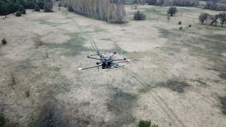
The use of UAV-Lidar is being tested in the complex terrain of the Chernobyl Exclusion Zone. The aim of the University of Bristol team is to demonstrate that, in the event of a nuclear incident, it could be possible to use a drone instead of manned aircraft to provide real-time situational data about the spread and intensity of the radiation.
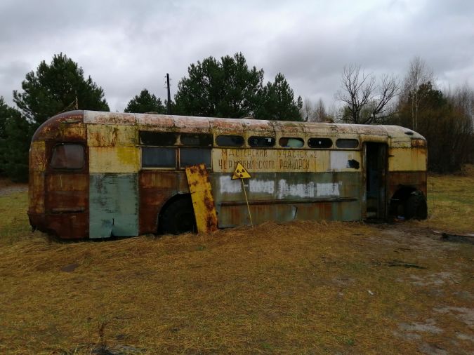
The release of radionuclides from the Chernobyl Nuclear Power Plant (ChNPP) in 1986 remains the most significant nuclear accident in the history of civil nuclear power generation. The surrounding area, known as the Chernobyl Exclusion Zone (CEZ), is amongst the most heavily radioactive contaminated areas on the planet. In the aftermath of such a large-scale release of radioactive material into the environment, it is critical to effectively determine the spatial distribution of radioactivity. A considerable inventory of highly radioactive material still remains within the surface environment of the CEZ, plus there is insufficient radiological monitoring and hazard awareness. Since the 2019 television miniseries called Chernobyl, tourist interest in the CEZ has surged, with annual visitors exceeding 124,000 by the end of that year. Despite the subsequent drop in visitation in 2020 and 2021 due to COVID-19, this increased human presence in the region underscored the absence of appropriate radiological protection and knowledge of potentially lethal radioactivity hotspot locations. Monitoring and understanding the impacts of the present and evolving nature of radioactive contamination, both on the ground and airborne, are therefore essential for both human safety and the local ecology.
The Project to Map Chernobyl
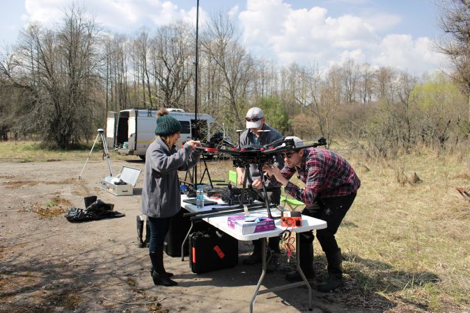
The UK’s University of Bristol is undertaking several robotics projects in close partnership with local Ukrainian institutes to address the need for radiation mapping in the CEZ. The Mapping Chernobyl project aims to help increase the efficacy of monitoring and mapping, and develop novel, effective methods to almost eliminate direct human risk. Professor Tom Scott, project leader, comments: “This unique environment also allows us the opportunity to test novel fixed-wing unmanned aircraft systems (UASs) equipped with radiation mapping capability to demonstrate that, in the event of a nuclear incident, it could be possible to use a UAS instead of manned aircraft to provide real-time situational data about the spread and intensity of the radiation.” This project will deliver insights to scientists examining the global environmental hazard presented by the highly mobile contamination present in the CEZ and to those responsible for managing the radiological safety for residents and others accessing the region.
The Bristol Team on the Ground
The team is highly multidisciplinary, covering air, ground and underwater robotics, with members of the robotics group primarily from engineering and physics training and backgrounds. Beyond the current Chernobyl project, the group have been involved in several other types of geophysical surveys using unmanned aerial vehicles (UAVs or ‘drones’), including hyperspectral and thermal imaging. In recent years, however, they have focused on the nuclear industry, mapping both anthropogenic and natural radiation sources. Previous research involved deployed gamma mapping UAVs in diverse locations around the world including the UK, USA, Japan, Romania, Portugal and the UAE. For example, they worked closely with volcanologists to measure and map volcanic gas plumes in remote locations where, similarly to nuclear sites, safety issues preclude physical access. The team dropped sensors into the vent of a volcano to aid the prediction of major eruptions. These deployable sensors, named ‘Dragon Eggs’, will be further developed in future to provide more regular measurements between the less-frequent mapping events.
In the decades since the accident at Chernobyl, remote/automated characterization technologies have advanced considerably. In particular, UASs with radiation mapping capabilities have been shown on many occasions to provide excellent results when it comes to mapping radiation in and around post-disaster environments. Throughout these projects, the technology has continued to evolve, becoming more automated, more accurate and more sensitive. For the current project, the team have developed – and are deploying – a range of advanced sensor systems collecting real-time data in the CEZ.
UAV-Lidar: The Most Suitable Approach
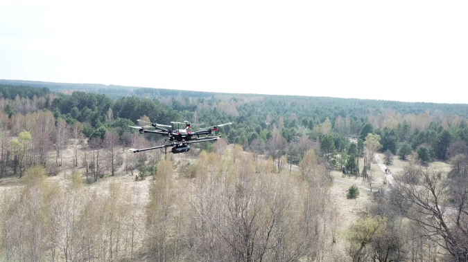
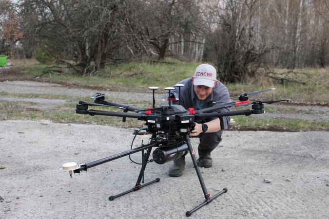
Lidar was considered the advantageous approach in comparison with traditional manned aircraft methods, which are capable of mapping large areas quickly but have substantial drawbacks in some contexts. These include low spatial resolution due to the operating altitude of the aircraft, and the risk of exposure to potentially harmful ionizing radiation for operators. Routescene’s LidarPod was the ideal system to use since it enables the collection of accurate data with high resolution outputs and is deployable in complex, hazardous settings such as this nuclear site. Dr Kieran Wood, aerial-robotics specialist on the project, recounts: “One of the research targets is to develop a more accurate method to map the radiation pattern in an area. Part of this process requires a high-accuracy 3D model of the physical structure and terrain, and Lidar is an ideal choice for 3D mapping in complex terrain. Since most of the radioactive material is contained in the ground, we also needed to have a bare-earth model only, and post-processing the Lidar can provide this with high accuracy.” Photogrammetric methods were used in conjunction with the LidarPod system since they can also produce highly accurate 3D models of structures and terrain. Besides mapping with the gamma and Lidar sensors, the UAVs were also equipped with cameras which enabled the team to collect photogrammetric image sets in parallel. It was generally faster to process the photogrammetry data for these flat terrain areas. However, Lidar would be more beneficial in some of the complex CEZ contexts, including near-vertical structures, according to Wood.
The Lidar data the team collects at the CEZ has the potential to be used for other purposes, such as to estimate the volume of vegetation. A large amount of radioactivity has been drawn up into the trees and plants in the environment via their root systems as they have grown over the years. Forest fires are a regular occurrence in the CEZ and surrounding areas. A forest fire in the ‘Red Forest’, a woodland area located closest to the reactor and therefore the most heavily contaminated, could release radioactive particles present in the trees. In this context, the Bristol team’s estimate of the volume of burnt material can be used to forecast the impacts of a fire on the region, thus supporting local safety, planning and management objectives.
The Characteristics of the Mapped Area
The surroundings that the team have mapped to date using aerial Lidar are mostly re-natured areas. They were originally small towns, villages and industrial sites, but many structures and forests were demolished and buried during the post-disaster clean-up activities. The terrain is now a mix of the remnants of these structures, some natural woodlands and some newly planted trees to maintain soil integrity. The terrain is very flat, which is ideal for this exploratory research since it simplifies the flight pattern requirements and allows a single consistent altitude to be used.
The primary measurement is gamma radiation intensity, which can pass through tens of metres of air quite easily. Wood explains: “By fitting a gamma detector onto a UAV and flying above the terrain, variations in the measured gamma intensity can be mapped, then post-processing enables interpolation of the measurements into a complete map. The localization then became relatively simple, since the hotspots were clearly indicated by very localized peaks in the measured radiation intensity. The measurements are all geotagged with GNSS receivers, hence the visual interpretation of the gamma map can tell us the longitude and latitude of the radiation hotspots.”
Safety and Risk Management
The entire area surrounding the damaged Reactor Number 4 was contaminated with fallout from the explosion and fire, and the level of gamma radiation remains elevated in many areas. Since 1986, however, the intensity of the radiation has reduced substantially. The primary radiation hazard is the reactor itself, along with a few limited areas that have anomalously high activity, including the Red Forest immediately to the west of the ChNPP. Areas at the centre of the Red Forest are still too radioactive to access, which makes remote inspection using robotics essential. To overcome these access issues, the team kept strictly to safe areas proven to have acceptably low radiation levels and deployed the drones from these safe zones over the areas in which the radiation was higher. Although the drones were exposed to higher levels of radiation in these areas, this did not make them radioactive themselves. Since contamination would only occur if the vehicles touched the surface, the UAVs remained safe for operators to handle between flights.
Ongoing Challenges Faced
The CEZ is still closed to any commercial developments and the only inhabitants in the region are people working plus soldiers for security. One of the main challenges the team faces is working with limited facilities, including a lack of mobile phone coverage. The team must therefore be self-sufficient and self-contained, running operations using equipment that can be delivered by truck. Despite the best efforts to maintain safety, however, there are still some risks. For example, if anything were to go badly wrong, outside assistance is very difficult to access. This is further complicated by the inability to directly assess the presence or height of any obstacles. The team overcame this by developing a two-stage approach to flight planning: firstly, a multi-rotor UAS was manually flown to assess the minimum acceptable altitude, and secondly, the fixed-wing was programmed to perform a wide-area survey. It is important to minimize altitude since it has a direct impact on the resolution of the resulting maps.
Importance of the Project and Its Outcomes
The end product of the survey conducted by the Bristol team was a more accurate gamma map of the target areas, shared with the team’s Ukrainian partners. For the university researchers, the end product of the project was to develop new methods. This was a first demonstration of a fixed-wing radiation mapping drone with a much longer range and area coverage than its multi-rotor counterparts. The team are continuing to refine data post-processing algorithms using the unique data collected. Powerful tools will be developed for the use of those managing and monitoring the zone.
Some of the resulting maps were implemented in April 2020 to support the response to extensive forest fires started in the CEZ that ravaged the region and began to move towards the Red Forest. There were concerns of a major radioactive release, so the radiation maps were used by the UK Meteorological Office and later NASA to model the likely release scenarios. Thankfully, the fires were extinguished by rain before they reached the Red Forest.
Next Steps and Future Plans
The University of Bristol has a very strong nuclear robotics team. They are continuing to work with the ChNPP to perform mapping as well as innovate new devices, sensors and methods to help with remediation activities. COVID-19 has delayed the field testing of new devices. However, the team plan to return as soon as possible to continue their work on this important project.

Value staying current with geomatics?
Stay on the map with our expertly curated newsletters.
We provide educational insights, industry updates, and inspiring stories to help you learn, grow, and reach your full potential in your field. Don't miss out - subscribe today and ensure you're always informed, educated, and inspired.
Choose your newsletter(s)


