Measuring Real-time 3D Position in GPS-denied Environments
Racelogic has launched a brand-new indoor positioning system, called VIPS, which is an advanced system for measuring real-time 3D position to an accuracy of ±2cm in areas where GPS is not available. This makes it an ideal tool for construction applications both indoors and in urban areas. The system has been designed for any application that requires accurate measurement and recording of 3D positioning. It enables GPS-based technologies to operate in GPS-denied environments.
The British developer of accurate GPS data loggers, testing equipment and positioning systems presented this innovative technology at the London Build Show in November 2019. It included live demonstrations and the opportunity for construction engineers, integrators and technical partners to explore just how effective VIPS could be when applied to real-world problems.
Potential applications
Discussions are already underway with construction partners to implement VIPS for applications including indoor/outdoor surveys, snagging, augmented reality, machine control, crane safety, depth measurement and automated guided vehicles. However, the flexibility of VIPS and the option for bespoke adaptation means there are no limits to the potential applications of this innovative technology.
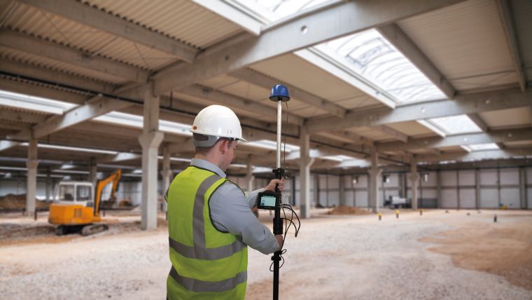
VIPS consists of Fixed Ultra-Wideband (UWB) beacons which are placed around the perimeter of the operation area (e.g. floor plan of building or construction site), in known positions which have been manually surveyed using a handheld laser, total station or, if time is of the essence, a self-survey can also be performed. The beacons are completely stand-alone, and can be battery powered, making the deployment very rapid.
Real-time 3D position
A fixed or hand-held receiver continuously communicates with the beacons and triangulates its position. This data is combined with the measurements from a highly accurate inertial measurement system, providing a real-time 3D position to within 2cm.
The data can be viewed live on a Racelogic VBOX Touch and coordinate locations can be saved to an SD card so that they can be efficiently revisited at a later time. The position and speed are also output over an RS232 link, WiFi, Bluetooth or onto a CAN bus, allowing easy connection to third party equipment.

Value staying current with geomatics?
Stay on the map with our expertly curated newsletters.
We provide educational insights, industry updates, and inspiring stories to help you learn, grow, and reach your full potential in your field. Don't miss out - subscribe today and ensure you're always informed, educated, and inspired.
Choose your newsletter(s)


