Using PPP corrections in precise real-time applications
Minding the gaps
Satellite-delivered GNSS correction services can be used in many real-time applications where real-time kinematic (RTK) and virtual reference stations (VRS) are not available. In areas without regular communication systems, satellite-broadcast PPP corrections can deliver centimetre-level positioning worldwide in real time.
While geospatial professionals who use RTK and VRS enjoy reliable, cost-effective performance in a broad array of tasks, there are many instances where conditions conspire to make working in real time difficult or even impossible. For example, hilly terrain may block radio signals from an RTK base station, while inconsistent cellular coverage can disrupt or cut off communications with the VRS network. In many locations, VRS service is not available at all and accurate geodetic control marks needed for RTK are unavailable. To fill these gaps, users can turn to precise point positioning (PPP) technologies.
Modern approaches to PPP enable users to obtain real-time GNSS positions with centimetre-level accuracy horizontally and sub-decimetre-level accuracy vertically. With PPP integrated into existing geospatial workflows, users can choose RTK, VRS or PPP to optimize their productivity while obtaining the required accuracy in situations where real-time positioning has up until now been impractical or overly expensive.
Trimble CenterPoint RTX
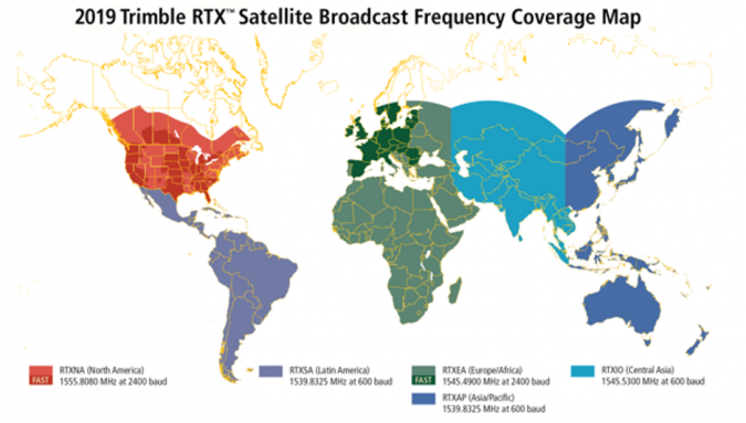
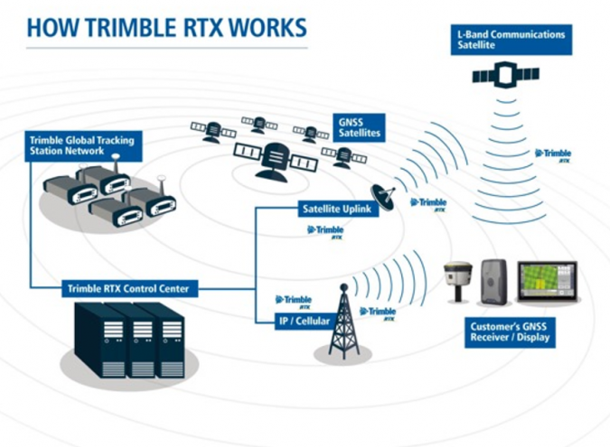
Trimble’s approach to PPP is called RTX and consists of three parts. First, Trimble operates multiple control centres to provide redundant, highly secure data management, processing and distribution. Second, a network of more than a hundred GNSS tracking stations around the world streams multi-frequency, multi-constellation data (GPS, GLONASS, Galileo, BeiDou, QZSS) to the control centres. Advanced data processing algorithms analyse the three main error sources – satellite orbits, clock offsets and atmospheric effects – and develop models and correction data. For example, the satellite orbits are modelled with an accuracy of one to two centimetres in real time, which is a significant advantage over the broadcast orbit data that is accurate to roughly one metre. The GNSS tracking stations are constantly checked for performance and stability to ensure accuracy of modelling and correction data. Third, the data is delivered to GNSS rovers via L-band satellite communications using geostationary satellites or, where available, wireless internet. The rover combines the correction data with its own satellite observations to produce accurate positions.
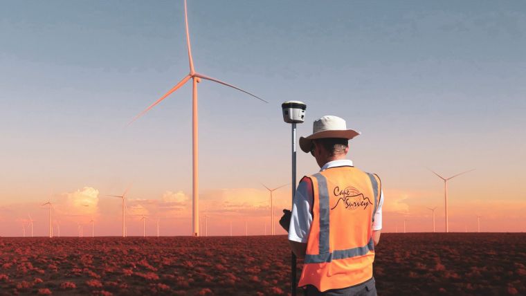
The ability to produce high-accuracy positioning also relies on the increasing capability of hardware in the field. New-generation rovers such as the Trimble R10 have the ability to track all available GNSS signals and L-band communications, and also have the computing horsepower to handle the data and complex computations. The highest-accuracy RTX service, CenterPoint RTX, can produce horizontal accuracy of 2cm RMS.
With more data from more stations fed into improving algorithms, the time needed to obtain high-accuracy positions is improving as well. Users can typically obtain an accurate PPP solution anywhere in the world in less than 15 minutes. In many areas, including much of Western Europe and North America, the higher density of tracking stations in the RTX network supports more accurate regional atmospheric models that allow initialization in less than one minute. Once the initialization is complete, GNSS users can work in the same manner and with the same accuracy as with RTK or VRS.
PPP vs RTK/VRS
PPP systems such as RTX are not a replacement for RTK or VRS. Rather, they are complementary or supplemental to those methods. The satellite-delivered PPP corrections help users to maintain productivity when they would otherwise be forced to use approaches that are slower or less accurate. This is the result of satellite corrections having a different transmission profile from RTK or VRS as considered in the examples below:
- VRS users require a connection to the internet, typically via cellular networks. A lost connection can result from technical issues with their cellular provider or from simply moving behind a hill or outside of the cellular coverage and losing cellular connection. Because RTX uses satellite delivery for its correction data, users can continue to operate provided they have a clear view of the sky in the direction of the geostationary communications satellite(s). When cellular connection is regained, they can resume operation in the VRS.
- For accurate positioning outside of VRS coverage, both PPP and RTK can be solutions. However, PPP eliminates the need to set up, move and manage local base stations. Additionally, many RTK operators use cellular communications to transmit corrections from their base stations; they are vulnerable to the same communications limitations as VRS.
PPP applications
PPP solutions such as Trimble RTX have been used for years in agricultural settings, where farm operators need 24/7 positioning for precise agriculture applications. The system is also used in an even more critical application: autonomous vehicles. The Cadillac Super Cruise hands-free driving assistance system relies on CenterPoint RTX to provide the consistent, accurate positioning needed for safe operation of the cars.
Satellite-distributed PPP corrections are also useful in the land survey industry, such as for cadastral surveys in the back country far from suitable control, for example, or for establishing control in aerial imagery for large-scale projects in areas not covered by VRS and with poor cellular coverage.
Looking ahead, PPP points to more flexibility for GNSS users across the board. It is reasonable to expect growth in location-based applications that can benefit from high-accuracy real-time positioning. Besides that, industry trends indicate further expansion of fast initialization availability together with increased use of PPP in the traditional geospatial markets. By acting as a complement to RTK and VRS, PPP is a proven and cost-efficient tool to enable geospatial professionals to provide improved service and value to their clients.

Value staying current with geomatics?
Stay on the map with our expertly curated newsletters.
We provide educational insights, industry updates, and inspiring stories to help you learn, grow, and reach your full potential in your field. Don't miss out - subscribe today and ensure you're always informed, educated, and inspired.
Choose your newsletter(s)


