Mobile Lidar for Urban Streetscapes
Mapping Historic Sixth Street in Austin, Texas
Surveying And Mapping, Inc. (SAM, Inc.) performed a mobile Lidar survey of the historic Sixth Street district in Austin, Texas, USA, for an urban planning project being conducting by the municipality. Sixth Street is an acclaimed music and entertainment district in the heart of downtown Austin, and city planners intend to redevelop it, broadening the pedestrian streetscape and improving both vehicular and pedestrian traffic control. Using mobile Lidar technology to survey this busy street significantly shortened data acquisition time and provided survey-grade deliverables to the city. The detailed point cloud dataset was also made available to city planners for 3D planning and visualisation.
In 1996, the City of Austin, Texas, began work on its Great Streets Master Plan project to improve the quality of downtown streets by transforming the public right-of-way into public spaces that were accessible and comfortable, with an aesthetic pavement network throughout. As the City of Austin Planning and Development Review Department stated in its vision, “A community’s downtown is the heart of that community, and its streets are its primary public spaces for downtown life and commerce.” A typical Great Streets layout included pavements 18 or 32 feet (5.5 or 10 metres) wide, street furnishings such as benches, bike racks and litter bins, and contiguous canopy of mature trees to provide shade. After discussions between the city’s planning staff and a local non-profit organisation comprising property and business owners in the historic Sixth Street corridor, the city began preliminary planning for the East Sixth Street corridor in keeping with the Great Streets plan.
This historic streetscape includes rich and varied architecture, so any work to expand pedestrian facilities would require careful integration with the existing buildings. It was crucial to the City of Austin planning staff that they had detailed and accurate information of all visible, above-ground street features (including drainage, water, wastewater and storm sewers), and they had a particular need to be able to identify the various paving materials, details of buildings’ facades, column-supported overhangs and floor elevations for all building entrances.
SAM, Inc. was contacted by the City of Austin to perform a design survey of seven blocks of East Sixth Street in downtown Austin, including five intersecting streets. During initial project planning discussions, City staff expressed concerns about accessibility and safety when working on this project in active downtown streets.
Gathering this information using traditional surveying techniques would require time-consuming and costly closures to traffic lanes for an extended period of time. In view of the high level of detail the City needed for this dense urban environment and the potential accessibility and safety issues involved in working at the project site, it was clear that using mobile Lidar mapping technology could address these concerns and deliver value to the City.
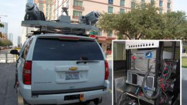
Mobile Lidar
Mobile Lidar is an innovative mapping solution that incorporates the most advanced Lidar sensors, cameras and position/navigation equipment to collect survey-quality point data quickly and accurately. SAM’s mobile Lidar vehicle utilises two 360-degree Lidar sensors, two five-megapixel cameras, two GPS receivers and an Inertial Measuring Unit (IMU) to provide data density of up to 1,600 points per square metre, depending on system settings. This non-invasive method of surveying can be operated day or night and collects millions of 3D points per minute, allowing for faster coordinate acquisition that far exceeds the efficiency of traditional survey methods.
Mobile Lidar technology is ideal for projects requiring an extraordinary level of detail, such as streetscape design. The accurate point cloud datasets offer a ‘complete picture’ of the project site and can be processed for survey-grade deliverables, 3D visualisation and modelling and other project needs without additional mobilisation costs. Using mobile Lidar technology, the survey-grade data the City needed was collected in a fraction of the time it would have taken conventional surveying methods. Since data was collected remotely and in early morning hours, removing the need for traffic diversion required by traditional surveying activities, the system also provided increased safety for project personnel and the general public. The value this unique technology provided to the City and the forward-looking potential uses of the data proved an excellent fit.
Project Control
In order to achieve the survey-grade accuracy required for this topographic design survey, SAM recovered and used primary survey control data provided by the City of Austin Engineering Services Division (NAD83/93/NAVD88 values [Texas State Plane, Central Zone]) and SAM field crews set secondary control targets at each block. The secondary controls acted as observed targets during the mobile data collection so that their known locations could be used to calibrate the point data.
Data Collection
This seven-block area of East Sixth Street is at the heart of Austin’s downtown entertainment district. Restaurants and music venues draw heavy foot traffic on the pavements while the street provides vehicular access to many downtown businesses. This density of pedestrian and vehicular traffic presented a challenge of access for both field personnel and Lidar data capture. To address this challenge, mobile Lidar data collection was scheduled for early on a Sunday morning to minimise potential obstructions (pedestrians or vehicles that could create data voids in the Lidar point cloud). SAM, Inc.’s mobile Lidar vehicle arrived at the project site at dawn and the data acquisition was complete less than four hours later, during which time technicians had collected more than 3.7 billion data points along the project corridors and over 20,000 georeferenced digital images (collected at three frames per second).
Data Procession
For the benefits of mobile Lidar to be fully realised, the surveyor must effectively manage the huge amount of data collected and extract precisely what the client needs in the required format. As one of the first firms in the U.S. to add mobile Lidar to its collection of services, SAM was able to deploy tested workflows to efficiently process Lidar into a final product specific to the City’s needs.
Using disk extraction software, SAM mobile mapping technicians downloaded the laser range data and digital images. Raw trajectory data were also downloaded from the system operation laptop. The company then produced a smoothed best estimate of trajectory (SBET) using positional data collected by the mobile Lidar system (GPS, IMU and DMI), which correlated with the primary and secondary controls collected at the project site. Using software that geospatially references the laser data to the trajectory through a time relationship, LAS files (a public file format for the interchange of 3D point cloud data) were created and calibrated to ground-control targets. Mobile mapping technicians then used specialised software to organise and manage the files and to tie the laser scan data to the ground-control data for improved geometric accuracy.
Final Deliverables
With the creation of a controlled and corrected dataset, the mobile mapping technicians began the extraction process to collect all the relevant features within the project area: above-ground and visible street, drainage, waterline (valves, meters, manholes, hydrants and sprinklers), wastewater and storm sewer features, detailed data from the buildings’ facades, the location of column-supported overhangs and building entrances facing the street, including all steps and finished floor elevations. Miscellaneous features such as signs, utility poles, guy anchors, overhead power lines, traffic control facilities and utility appurtenances were also located.
The extracted topographic survey information was processed and delivered in Autodesk Civil 3D, using the City of Austin’s ESD CADD Standards, drawn on the appropriate level and in the format required by the City. This allowed the data to be seamlessly integrated into the preliminary engineering design efforts for the City.
Added Value
While not a part of the initial scope of work, the Lidar dataset collected on East Sixth Street lends itself to a number of other applications that could provide added value to the City. With more than 3.7 billion data points collected in this seven-block area, this densely detailed dataset can be mined for future needs without additional mobilisation or data collection. Mobile Lidar can also be used for 3D visualisation for project planning. In this scenario, the stakeholders in the design process including engineers, architects and City staff – and potentially the public –can view and navigate the project area in 3D, which provides an enhanced understanding of project details and progress. Also, with supplementary processing and manipulation, this dataset can be rendered into a detailed, colourised 3D model of the project location, showing the unique architectural details of the buildings’ facades. This model can be integrated with architectural plans throughout the design phase to give both designers and the City a realistic depiction of the enhanced streetscape.
Summary
Using mobile Lidar technology, SAM was able to deliver a highly accurate topographic survey of a dense urban environment. The data was collected in a fraction of the time it would have taken using conventional survey techniques, without costly lane closures and with no danger to field crews or the public. Additionally, the detailed dataset can be used for 3D visualisation and modelling and other project needs without additional mobilisation costs.
Acknowledgements
Special thanks to the members of the City of Austin Public Works Department for their forward-thinking approach to
this project.

Value staying current with geomatics?
Stay on the map with our expertly curated newsletters.
We provide educational insights, industry updates, and inspiring stories to help you learn, grow, and reach your full potential in your field. Don't miss out - subscribe today and ensure you're always informed, educated, and inspired.
Choose your newsletter(s)


