Modelling the Great Wall of China
Mapping by Airborne and Terrestrial Lidar
The Great Wall of China is one of the largest manmade wonders of the world, comprising many different and irregular structures. We employed airborne Lidar to produce highly accurate digital elevation models (DEMs) to identify areas requiring repair. A terrestrial laser scanner mounted on a tripod was used to improve the terrain model, especially for surfaces covered with dense vegetation. The combined use of airborne and terrestrial laser scanner produced DEMs with accuracies better than 10cm.
The easternmost end of the Great Wall, Shanhaiguan Great Wall, is in the city of Qinhuangdao in Hebei. Although the wall is intact, the circumvallation has fallen into disrepair. In 2008 the national finance bureau and Hebei province designated special funds for renovation. A highly accurate and detailed three-dimensional map of the Great Wall was therefore required. The investigation described here was the initial step in the repair and reconstruction process.
Damage Assessment
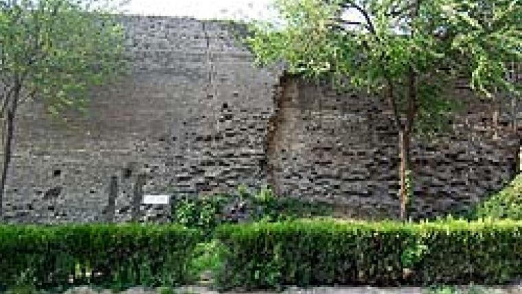
A map of the seriously damaged Shanhaiguan wall was needed quickly. A good deal of the wall is, however, sheltered by trees and vegetation growing on its surface, and some sections are covered in
soil (see Figure 1). Creating digital elevation models (DEMs) of the Great Wall using conventional engineering survey and photogrammetry stereo imagery has always been a challenge. A full investigation and comparative analysis led to the selection of Lidar technology for this purpose.
Mixed Technology
We employed several instruments to map the Great Wall. An airborne laser scanner (IGI LiteMapper 5600) utilising waveform digitisation recorded the full return waveform; maximum pulse rate was 100,000Hz, creating a medium-format airborne digital-camera system of 22 million effective pixels. Also utilised was a terrestrial laser scanner (Riegl LMS-Z420i) and processing software RiSCAN PRO. A calibrated and definitely orientated high-resolution digital camera (Nokon D2X), providing 12.4 million effective pixels was employed, as was a GPS and inertial measurement unit (IMU).
We acquired orthophotography (geometrically corrected aerial photography) and oblique texture data to achieve more realistic models. Orthophotographs were acquired at the same time as Lidar imagery. The coordinates of the Lidar and camera were determined using both Lidar and ground GPS. The IMU continuously measured aircraft pitch, roll and yaw. An oblique camera was used to map side texture to confirm precise point, line and surface measurements.
Airborne System
The narrow Lidar corridor meant we had to find the exact centre of the wall. We used a 1:50,000 relief map and historical photographs to obtain its basic location and GPS to derive the coordinates of the corners. To obtain enough laser points we conceived three lines for the Lidar system: one just above the wall and one on each side, 75 to 120m from it. The observation parameters are listed in Table 1. The project employed two ground GPS base stations, one at the south-eastern corner of the project area and the other 1.3km to the west.
Data was acquired on the western side of the wall when the angle of the sun was wide enough and shadows at a minimum. To measure the texture of this aspect of the wall, the oblique amera was flown along a trajectory 350m from each side of the centreline. For the western side, covered by vegetation, we added another line 225m to the west of the wall. DEM Calculation
The terrestrial laser scanner was used to obtain textures in these areas. Data pre-processing included checking the trajectory and coverage from the GPS and IMU data (Figure 2).
We first classified the laser data and eliminated points that belonged to neither the ground nor on the wall. We then calculated a DEM using the surface laser points, classified as ground points, wall points (Figure 3), building or vegetation. We geocoded each photograph on the basis of the classified laser data, created a mosaic and produced orthophotos. To obtain a high-quality digital orthophoto (DOM) we adjusted the colour of the image using software such as PhotoShop. Based on DEM and DOM data we achieved three-dimensional distance, acreage and volume measurements, section cutting and browse functions (Figure 4). We used the laser data to create a Triangulated Irregular Network (TIN) model. Orthophoto and oblique textures are based on the same geographical reference system, so they have an ‘exact space' relationship, allowing calculation of an accurate 3D-model of the Shanhaiguan Great Wall (Figure 5).
Accuracy Check
Hebei supervision and inspection measured 44 checkpoints by total station to check the accuracy of our measurements, and found them to be ±0.15m. Checking nine Jingbian tower elevation points by level gauge, a vertical accuracy of ±0.065m was obtained. Checking thirteen distance measurements with DEM and DOM data, average plane error was ±0.08m. For ten easily identifiable points vertical accuracy was found to be ±0.131m.
Good Combination
The combination of low-altitude, high-pixel photography and multi-side measurement technology reproduced the multi-angle textures of the Great Wall. Integration of new digital waveform Lidar technology and a terrestrial laser scan system allowed a DEM of the Great Wall to be calculated. The combination of high-definition, 2D photographs and 3D laser data enabled straightforward and accurate reconstruction of the Great Wall. The combination of Lidar and terrestrial laser scanner - the first of its kind in China - proved very effective for accurate and rapid imaging of manmade structures and urban areas.
Acknowledgements
Thanks are due to R. Kletzlib, Y. Huang, H. Liu, G. Zhao, S. Wang and all members of the project team.
Further Reading
BC-CARMS, 2006. LiDAR-Overview of Technology, Applications, Market Features& Industry. See http://carms.geog.uvic.ca/documents.html for further details.

Value staying current with geomatics?
Stay on the map with our expertly curated newsletters.
We provide educational insights, industry updates, and inspiring stories to help you learn, grow, and reach your full potential in your field. Don't miss out - subscribe today and ensure you're always informed, educated, and inspired.
Choose your newsletter(s)


