Multi-sensor Cave Detection in Bulgaria
Meeting the Challenges of Complex Karst Environments
Caves are important in a wide variety of fields, ranging from construction engineering to mineral exploration and archaeology. Despite the scientific importance of caves, geologists believe that only a relatively small number of them have been discovered so far. Exploration is currently mainly conducted by speleologists but this is a time-consuming activity and is limited to exploration based on existing surface openings. A recent project in Bulgaria has shown that the combination of multiple geophysical techniques provides an easier and effective on-surface exploration method that meets the challenges of complex karst environments.
(By Tanya Slavova and Atanas Rusev, Bulgaria)
Several geophysical techniques are recommended for cavity exploration, such as ground-penetrating radar (GPR), gravimetry, magnetometry, electrical resistance surveys and seismic reflectivity. However, their indirect on-surface application is related to some uncertainties due to the complex and dynamic nature of karst environments. For instance, one can never be sure in advance whether it is a dry or a water-filled cave or whether it has sediment cover (which makes it unsuitable for specific instruments). Another challenge is that a small cave at a certain depth may produce similar sensor observations to a larger cave at a greater depth, thus causing mapping ambiguities. Therefore, multi-sensor exploration, which relies on different physical properties of the environment, gives better results than an increased accuracy of a single technology. The combination of different technologies with additional information (such as details of local geology, subsurface features and topography) can further improve the results. In the research presented in this article, a surveying campaign has been conducted both on the surface above a known cave and inside it to investigate the effectiveness of multi-sensor cave detection.
Karst Labyrinths
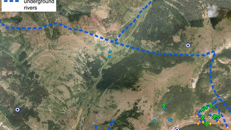
The Bosnek karst region, the test location, is famous for the Duhlata cave which is the longest cave system in Bulgaria (Figure 1). With the connected underground spaces stretching for 18 kilometres, Duhlata is an impressive and sophisticated labyrinth. However, it is predicted that the known area comprises less than 10% of the total cave system, which leaves a large part still to be explored. Of much smaller size but similarly interesting is a pulsing spring near Duhlata called Zhivata Voda (‘The Living Water’).The irregular intervals of its water flow are the subject of various legends and superstitions, but scientific interest is focused on the subsurface features that actually cause the irregular water flows (Figure 2). A cave of the same name is situated about 100 metres away from the spring, and two other caves are also in close proximity. The entire area is a complex karst environment, making it a suitable test location for the multi-sensor exploration method.
Geophysical Techniques
For the study, a combination of gravimetry, GPR and magnetometry was used. Gravimeters are sensitive to density changes (and work best if caves are dry), GPR is an active radar system that maps the reflections of radar pulses and magnetometers are able to discover anomalies due to different underground environments by measuring the magnetic field precisely. The common advantages of all three geophysical techniques for this research were their portable instrumentation, one-man operation and silent and non-intrusive performance. Nevertheless, the mountainous nature of the investigated area still remained a challenge for normal operation. In addition, accurate station positioning information (especially heights) is required for gravimetry, which is difficult to achieve in areas with poor GNSS coverage (such as deep in the forest). The three on-surface techniques were complemented by 3D mapping of a known cave within the investigated area, the Zhivata Voda cave. This model served for field calibration in order to study the multi-sensor effectiveness, as well as to improve data analysis and interpretation. Bringing all of the datasets together was a challenging but essential task for interpreting the final results.
Sensor Setup
The equipment consisted of both modern and classical surveying devices. Some results were available in real time, but others first required post-processing. The gravimeter used was a LaCoste & Romberg G with a sensitivity of 0.04mGal. The GPR was the MALÅ X3M, equipped with a 250MHz antenna. For magnetometry the GSM-19 magnetometer from GEM Systems was chosen with a resolution of 0.01nT. According to the gravimeter sensitivity, the accuracy threshold was 13cm for the height of the stations at the measurement locations. To achieve this, an integrated GNSS handheld Trimble Geo 7X (that supports GPS, GLONASS, BeiDou/Compass and Galileo) was used together with the external Zephyr II antenna on a 2m-high pole to make it easier to reach the required accuracy (up to 1cm was reached). The handheld also had an integrated laser rangefinder module including a digital compass and clinometer, which was useful in enabling offset measurements. A Leica TCR303 total station was used for all tasks that required high accuracy but where a poor or no satellite signal was available.
Surveying Campaign
The fieldwork consisted of two parts: a cave survey and subsequently on-surface measurements. Because of the relatively large galleries and mostly flat base of the Zhivata Voda cave, mapping it was a relatively easy task (Figure 3). The traverse of the cave consisted of several measurement locations; their positions were chosen based on line of sight and specific formations to be surveyed. The absolute position of the cave was determined through GNSS measurements at the entranceThe on-surface measurements were carefully planned in advance using the available topographic data of the region as well as existing information on the Zhivata Voda cave. The measurement grid consisted of about 180 points, each spaced two metres apart and spread over eight rows positioned approximately along the terrain contours. First, the grid points were laid out roughly by performing offset measurements with the handheld’s rangefinder through the vegetation and rocks in order to choose the most suitable locations for the measurement stations. Next, due to the significant tree canopy, a combination of GNSS and total station measurements was applied. The use of the magnetometer was the easiest part of the fieldwork with several seconds spent on each station. Pulling the GPR across the hillside was physically harder (Figure 4) but the gravimetric measurements were the toughest part, taking on average 10 minutes per point and sometimes even longer.
Cave Model
All measurements were post-processed to improve the GNSS accuracy and to combine them with the total station measurements. The in-cave measurements, which consisted of about 350 points from four stations, were used to approximate the 3D layout of the cave. The measurement approach applied differs from a typical cave survey, which uses more stations but measures only four points per station (ceiling, floor and the two sides). Therefore, codes were used to mark the measurements in order to be able to distinguish between the floor and the other points. The model generated in AutoCAD Civil was used to obtain information on the shape, size and depth of the cave.
Data Improvements
Although the GPR data was available in the field, it was post-processed with MALÅ Object Mapperand GroundVision, applying different filters to improve data analysis. The results were presented along the surveyed profiles. The magnetometer data was presented with Surfer on a map. Gravimetric data usually requires topographic corrections to obtain accurate results (especially in a mountainous region like the test region). For the research area of this investigation, topographic corrections for an area of more than 10 x 10km were calculated based on a combination of SRTM data, digitised topographic maps and the GNSS measurements acquired in the investigation itself. The resulting gravimetric data was filtered to improve data consistency.
New Cavities
Both the gravimetric and magnetometer results were presented as a 2D map which could be compared to the cave layout based on the in-cave measurements, but direct interpretation remained challenging. The filtered gravity data suggested the presence of two more cavities within the explored area (Figure 5). One of them was situated in the south-eastern periphery of the grid and this matched with a spring at the foot of the rocks there (measurement points E4-D4). The other one was located west of the cave near measurement points B21-22 and A21-22. Due to the lack of a sediment layer to block the electromagnetic signal, the GPR technology was successfully applied and showed similar results to the results of the gravimetry and magnetometry data (Figure 6).
Further Developments
The geophysical methods used in this investigation each have their advantages and limitations in terms of exploration of subsurface features. When used together, they are a powerful tool for cave detection. However, their combined interpretation is not straightforward and will likely benefit from further spatial analysis in GIS. The available GIS data for the Bosnek karst region consists of information about the known and possible cave entrances, their subsurface development and possible underground river flows. In the current investigation it was used in the planning process only, but the gravimetric, GPR and magnetometric results could be integrated with these datasets for enhanced interpretation. The current investigation can also serve as a starting point for a more complex dataset of the entire region to, eventually, reveal the secrets of Zhivata Voda.
Acknowledgments
The authors express their gratitude to New Bulgarian University (NBU), University of Architecture, Civil Engineering and Geodesy (UACEG), Bulgarian Geoinformation Company (BGC), Karoll Financial Group and the people who reviewed this work.
Tanya Slavova is an engineer surveyor and currently a PhD candidate on the detection of underground cavities at UACEG, as well as a surveyor at BGC. Her interests include physical geodesy, GNSS and GIS. E-mail: slavova.tanya@gmail.com
Authors
Atanas Rusev is an engineering graduate and a GIS expert at BGC. He has also been a mountaineer and cave explorer at Club Extreme for 30 years. His interests include cave mapping, mobile GIS and GIS server implementations. E-mail: toltec@clubextreme.org
Figure captions
Figure 1, Map of the Bosnek karst region showing various information, such as cave entrances, springs and underground rivers.
Figure 2, The Zhivata Voda pulsating spring.
Figure 3, Performing the in-cave measurements.
Figure 4, GPR measurements just above the cave entrance.
Figure 5, Filtered gravimetric (up) and magnetometer (down) results of the area with the cave layout shown in red; the numbers indicate the grid measurement locations.
Figure 6, GPR results shown along profile 15 that starts above the cave entrance and goes up the hill.

Value staying current with geomatics?
Stay on the map with our expertly curated newsletters.
We provide educational insights, industry updates, and inspiring stories to help you learn, grow, and reach your full potential in your field. Don't miss out - subscribe today and ensure you're always informed, educated, and inspired.
Choose your newsletter(s)


