Multiplatform Lidar Use in Digital City Projects
CHCNAV AlphaUni 900 Application Case
Following its emergence more than a decade ago, digital twin technology has developed to become a complex and comprehensive technical system that supports the construction of new smart cities. It is also an advanced model for the continuous innovation of intelligent urban development and a future form of modernization of the combined ‘virtual and real’ world.
(This article is brought to you by CHCNAV)
The establishment of the digital twin city brings to the forefront high-level topographic tools that are able to deliver comprehensive, multi-dimensional, large-scale and high-resolution datasets. Traditional methods of collecting and representing 2D spatial data, such as maps and images, are no longer sufficient, and a complete upgrade of traditional surveying tools is required. As a result, there is high demand for global, accurate, real-time geospatial data that provides high-precision 2D and 3D information.
Project description
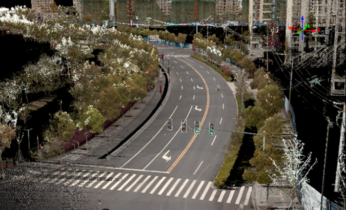
To illustrate a typical digital city project, we carried out a proof-of-concept demonstration in the Jinshan district of Shanghai. The total area of the Jinshan district is approximately 600km2. This area contains rich terrain features and typical characteristics of large, modern cities, such as high-rise buildings, power lines, rivers and vegetation.
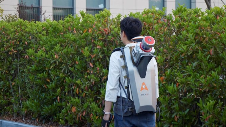
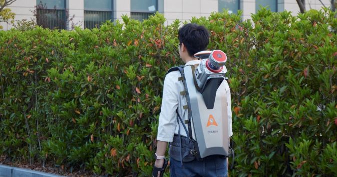
The traditional method of capturing a single-platform Lidar system may leave some areas blank in the point cloud data. The AlphaUni 900 Lidar solution, with its multiplatform capability, can easily capture complete data from a UAV, car, backpack or boat, and can produce a sophisticated 3D image. The AlphaUni 900 Lidar system integrates the real buildings seamlessly, provides outdoor and indoor mapping, and greatly changes the way that high-precision data is collected.
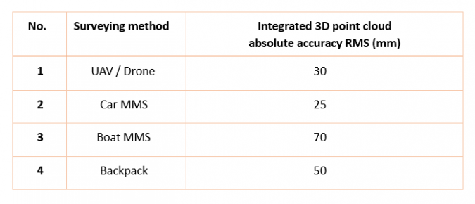
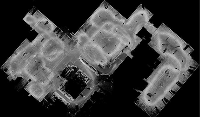
Data accuracy and merged results
Final data accuracy after point cloud data integration from multiple platforms.
The solutions
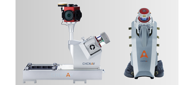
ALPHA3D - CHC Navigation offers geospatial professionals a premium high-performance, vehicle-independent mobile mapping solution to capture 3D mass data in continuously changing world environments. Whatever the application, the Alpha3D mobile mapping system significantly increases your return-on-investment by completing work quicker and more accurately. Alpha3D combines state-of-the-art high-performance hardware, such as a long-range, ultra-high speed, precise laser scanner and a high-resolution HDR panoramic camera in combination with an advanced GNSS receiver and a high-precision IMU; all in one instrument with a lightweight and compact but rugged design. All of these features mean that Alpha3D is one of the most innovative mobile mapping systems in the market today.
ALPHAUNI 900 - AlphaUni 900 belongs to the Alpha Mobile Mapping family. These are high-end multiplatform Lidar systems that have been designed and improved by CHCNAV through many years of exploration and data capture experience. AlphaUni 900 offers a fully integrated system with high-precision, long-range laser scanners with unique Waveform-Lidar technology from Riegl and a high-accuracy inertial navigation system, ready for demanding surveying missions in the air and on the ground, requiring the highest data quality.
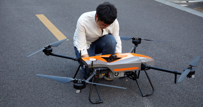
BB4 UAV - The BB4 is a high-end unmanned aircraft system resulting from an alliance between the two industry leaders in their respective segments. Its scientific design and highly integrated production technology come from CHCNAV – a global manufacturer specialized in efficient geospatial measurement technologies – and its fully automated flight control system from DJI, the pioneer in the manufacturing of commercial UAVs.
APACHE6 - The APACHE6 USV is a full-integrated innovative solution for 3D bathymetric surveys, underwater object positioning, offshore construction, underwater archaeology and wreck rescue. The APACHE6 is powered with a high-performance dual propeller system, ensuring a stable automatic cruise speed of up to 2.5m/s (7.6fps). Survey projects can also be completed in manual mode using the APACHE6 remote control panel over a 2km distance.
The APACHE6 multibeam USV reduces survey time, improves work efficiency and outputs high-resolution data to always match the most demanding marine survey project requirements.
Conclusion
Today, digital twin technology offers many advantages in a wide range of applications and uses. Traditional 2D and 3D surveying methods are not sufficient to meet all the requirements expected in digital twin city models, where digital data produced at large scales is used as the foundation of the projects.
The derived 3D models must have a high capacity to be merged and correlated with social or economic spatial data, for example from IoT (the Internet of Things) and big data.
The high-accuracy capability of the CHCNAV AlphaUni 900 and its multiplatform design successfully provide an innovative solution to the problems of 3D geospatial data acquisition required for the development of smart cities.
The AlphaUni 900 innovates the way we do mapping.

Value staying current with geomatics?
Stay on the map with our expertly curated newsletters.
We provide educational insights, industry updates, and inspiring stories to help you learn, grow, and reach your full potential in your field. Don't miss out - subscribe today and ensure you're always informed, educated, and inspired.
Choose your newsletter(s)


