National Grid Starts Aerial Lidar Inspections for Gas Network
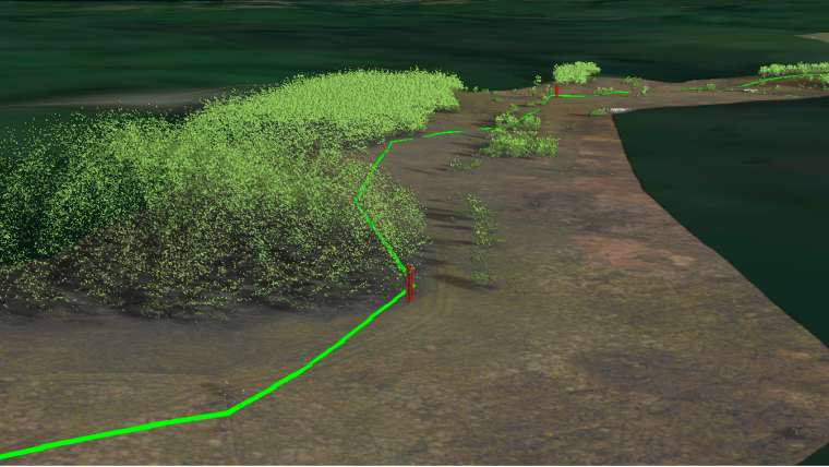
National Grid, a British multinational electricity and gas utility, has announced it is conducting a trial programme using laser scanning data to deliver safety and operational efficiency improvements across its network. In a UK gas transmission first, the operator will employ Lidar technology to monitor the terrain around the pipeline, using an airborne survey.
Working with NM Group, the Network Innovation Allowance (NIA) funded project will conduct multiple Lidar scans over a gas transmission pipeline section. The accurate 3D data will be used by National Grid to identify earth movement and update asset information. Additionally, by comparing the aerial flights, the project will identify any major changes within the project area. This will help identify safety concerns and detect any third-party interference on the network.
Interactive portal
Quentin Mabbutt, innovation delivery manager at National Grid, suggests that Lidar surveys offer considerable potential for the company to unify numerous pipeline asset integrity datasets within one interactive portal. Working alongside Ian Crompton of National Grid’s Pipeline Maintenance Centre (PMC) is providing the programme with a rich set of line walking data which greatly enhances the understanding of the topographical Lidar results obtained to date. It is hoped that the programme will enhance the ongoing management of the pipeline assets, he said.
Kevin Jacobs, managing director at NM Group, added the project presents a number of key benefits, such as reducing the cost of walking inspections and providing additional information on the network condition. Using NM Group’s 3D software, Caydence, this information is easily accessible within a single platform. National Grid is leading the way with this technology, and Jacobs said he looks forward to further collaboration during the project.
The project is expected to deliver efficiency and safety improvements across the network and, if successful, may provide a new approach to pipeline integrity monitoring.

Value staying current with geomatics?
Stay on the map with our expertly curated newsletters.
We provide educational insights, industry updates, and inspiring stories to help you learn, grow, and reach your full potential in your field. Don't miss out - subscribe today and ensure you're always informed, educated, and inspired.
Choose your newsletter(s)


