New and Improved Authoritative U.S. Land Cover Map
The latest edition of the United States’ most comprehensive look at land-surface conditions from coast to coast has been released, showing the extent of land cover types from forests to urban areas. The National Land Cover Database (NLCD 2011) is being made available to the public by the U.S. Geological Survey and partners.
Dividing the lower 48 states into 9 billion geographic cells, the massive database provides consistent information about land conditions at regional to nationwide scales. Collected in repeated five-year cycles, NLCD data is used by resource managers and decision-makers to conduct ecosystem studies, determine spatial patterns of biodiversity, trace indications of climate change, and develop best practices in land management.
The USA’s land and waters face unprecedented challenges from natural disasters, climate change, development pressures, and population growth, said Anne Castle, assistant secretary of the Interior for Water and Science. Prudently using their public land and developing their energy potential, while protecting the natural resources at the same time, requires a keen appreciation of how the landscape is changing over time and the causes of those changes. The digital view that the National Land Cover Dataset affords is sweeping, yet amazingly precise. It is one of the most important tools, for the Department of the Interior or any other land or water manager, in fostering an impartial perspective of landscape dynamics.
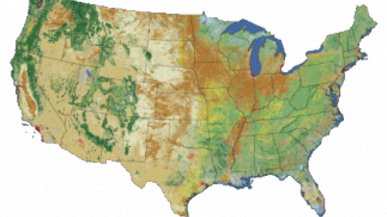
Landsat imagery
Based on Landsat satellite imagery taken in 2011, NLCD 2011 describes the land cover of each 30-metre cell of land in the conterminous United States and identifies which ones have changed since the year 2006. Nearly six such cells – each 98 feet long and wide – would fit on a football field. Land cover is broadly defined as the biophysical pattern of natural vegetation, agriculture, and urban areas. It is shaped by both natural processes and human influences.
NLCD 2011 updates the previous database version, NLCD 2006. The NLCD programme is designed to provide five-year cyclical updating of the nation's land cover, similar to the cyclical population updating done by the U.S. Census. NLCD is constructed by the 10-member federal interagency Multi‑Resolution Land Characteristics Consortium (MRLC).
Teamwork
The ongoing 20-year collaboration of the consortium is a model of cooperation among government entities, said Matt Larsen, USGS associate director for climate and land use change. Combining resources from MRLC member agencies to provide digital land cover for the nation is the best kind of teamwork. It not only advances land change science, but it also saves taxpayer money.
The range and the spatial accuracy of NLCD have made it essential to thousands of expert users. The carefully calibrated data enables managers of public and private lands, urban planners, agricultural experts, and scientists with many different interests (for instance, climate, invasive species or hydrogeography) to identify critical characteristics of the land and patterns of land cover change, informing a variety of investigations from monitoring forests to modelling water runoff in urban areas.
NLCD 2011 products depict 16 classes of land cover in the lower 48 states, define the degree of surface imperviousness in urban areas (impervious surface extent – concrete, asphalt, etc. – serves as a marker for urban environmental quality), and quantify the amount of tree canopy cover (essential for applications dealing with wildfire, carbon sequestration, wildlife habitat, and biodiversity).

Value staying current with geomatics?
Stay on the map with our expertly curated newsletters.
We provide educational insights, industry updates, and inspiring stories to help you learn, grow, and reach your full potential in your field. Don't miss out - subscribe today and ensure you're always informed, educated, and inspired.
Choose your newsletter(s)


