Northern Survey Flights: Subdecimetre Accuracy in Arctic Canada
Achieving Subdecimetre Accuracy in Arctic Canada
To increase capacity at Pangnirtung Airport, situated in a remote mountainous region of northern Canada, one solution could be to relocate the airport to one of two nearby sites. This article provides insight into how unmanned aerial systems were used in a preliminary engineering survey of both sites. The project achieved an accuracy of less than 10cm, despite the challenges including GNSS signal interference and difficult, rocky, rugged terrain.
Even for experienced pilots, landing an aeroplane at Pangnirtung Airport on the remote Baffin Island in Canada’s Nunavut province is at best a challenge; at worst, it is impossible. The airport is, however, the only reasonable way to reach this growing Arctic Circle community. Its capacity needs to be increased, but there is no room for runway expansion. One of the initiatives to address this issue would involve relocating Pangnirtung Airport to one of two sites on a plateau at 680m (2,230ft) above the town.
Survey set-up
At each of the two sites, a high-resolution preliminary engineering survey was required on which a detailed airport design could be based. These surveys also had to achieve a high level of accuracy: a vertical root mean square error (RMSE) of less than 10cm. Furthermore, since the terrain was so remote and rugged – accessible only on foot – the data had to be in order on the first attempt. As a result, a reliable, accurate system that could be taken into – and launched from – the field was needed.
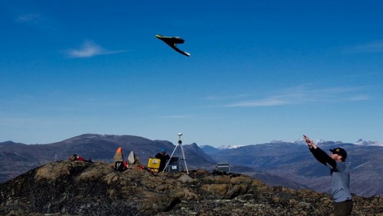
Equipped with RTK base stations, backpacks, sturdy shoes and senseFly eBee unmanned aerial vehicles (UAVs or ‘drones’), a team from the Canadian geomatics firm Ventus Geospatial performed the survey. Ventus has significant drone experience, having conducted over 4,500 eBee flights to date. The firm operates a fleet of drones from several manufacturers and recently became the first company to meet Canada’s stringent criteria for unmanned flight under BVLOS conditions. Ventus chose to fly eBees for the Baffin Island project due to their practicality and functionality, as well as their ability to deliver repeatable, reliable products.
The technique chosen was photogrammetry using the onboard camera from the eBee. Lidar was considered as an alternative in view of its good level of vertical accuracy: 10 to 15 centimetres. However, the client demanded under 10cm, which was shown to be possible with the eBee (4cm for X,Y and 8-9cm for Z) at around a third of the cost of Lidar.
To achieve the optimal balance between accuracy, resolution and flight coverage of the eBee’s S110 RGB cameras, a ground sampling distance (GSD) of 4cm per pixel was set, resulting in flights of 120m above ground level, covering 0.55km2 each. This relatively small-sounding coverage figure was a result of not only the flight height but also the high level of image overlap configured – 85% longitudinal and 80% lateral. This was necessary to ensure the quality of the resulting digital terrain model (DTM) and orthomosaic.
In total, four members of staff spent 16 days working on site. The project’s two drones captured a total of 16,000 photos, covering Site 1 (25km2) in 54 flights and Site 2 (15km2) in 42. Back in the Ventus office, three data processing experts worked for ten days – a total of 30 man-days – accumulating around 280 hours’ worth of image processing time to create the project’s core outputs.
Survey challenges
In the field, Baffin Island was a project full of challenges. For example, in locations so far north, GNSS signals arrive from near the horizon and can be badly affected by the ionosphere. The most recent receiver including GPS and Glonass technology is needed in both base and drone, along with strict quality controls to keep absolute accuracy levels high. For this survey the minimum elevation mask of the receivers was set between 10° and 13° instead of the more customary 15°. Quality controls ensured that only measurements were recorded where the geometric dilution of precision (GDOP) value allowed a Z error of under 3cm.
Due to the RTK capability of one of the two eBees used, a large part of the ground control point (GCP) setting which is customary for photogrammetry could be eliminated for those areas surveyed by that eBee. Although the need to measure over a very large area of terrain made a full GNSS survey with RTK base stations unfeasible, they were employed alongside the drones to set GCPs and measure checkpoints. Before sending the drones into the air, both of the project’s two-man survey teams set out on foot to set some of both sites’ pre-planned GCPs (100 and 200 respectively). These GCPs were laid out in a grid right across the sites, ready to be used as a solid, accurate data reference. Once the drones were in the air, one of the teams continued surveying GCPs to completion, at which point they started flying too.
With the eBee RTK itself, the base station providing RTK corrections to the drone was placed for one area on an existing monument. For the other area, 8-9 hours of logging raw data with subsequent post-processing of the static survey information tied the information into a known geodetic reference.
The mountainous terrain poses a challenge not only to real-life pilots, but also to the eBee. Using the virtually global coverage of the elevation data built into the flight planning software accompanying the eBee (eMotion), however, the drone flight plans could be optimised for the local topography even out at the most remote corners of each site.
Results
From the data, a DTM of 25cm-interval contour lines as well as highly detailed orthoimages were produced for both sites. Ventus Geospatial put significant effort into ensuring high absolute accuracy over the project’s entire 40km2 zone. After setting 300 GCPs and more than 340 additional checkpoints – measured with 2-3cm accuracy relative to the base station – these efforts paid off. Ventus achieved a level of vertical error (RMSE) well below the ordinarily acceptable 3 times GSD (i.e. 12cm). Both Ventus and the client consider the error observed to be a reflection of the very successful application of the technology in difficult, rocky, rugged terrain.

Value staying current with geomatics?
Stay on the map with our expertly curated newsletters.
We provide educational insights, industry updates, and inspiring stories to help you learn, grow, and reach your full potential in your field. Don't miss out - subscribe today and ensure you're always informed, educated, and inspired.
Choose your newsletter(s)


