Oblique Airborne Photogrammetry (1)
Properties, Configurations and Applications
Oblique airborne photogrammetry is rapidly maturing and entering the workflow of service providers. Many applications embrace the advantages of airborne capturing combined with slanted viewing geometry which comes close to human perception of scenes while standing on the ground. The authors provide an overview of the properties of oblique airborne images, the most common configurations and applications.
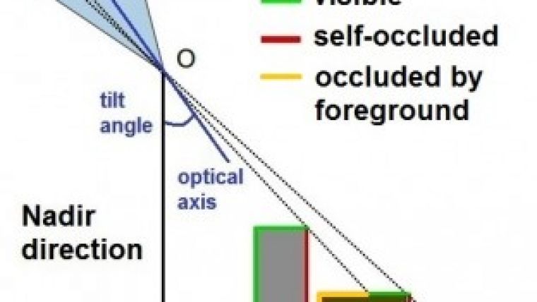
Today’s aerial surveys are often carried out using multiple small or medium-format cameras mounted together and simultaneously capturing nadir and oblique images. Oblique images capture the scene under a tilt angle, which is much larger than in nadir views. The tilt – the angle between nadir and optical axis – improves visibility of façades, lamp posts, trees and other vertical structures, but worsens occlusions and introduces large-scale gradients from foreground to background. Two types of occlusion may be distinguished: self-occlusion, for example when the rear side of a building becomes invisible, and occlusion by other objects (Figure 1). In the ‘north view’ of Figure 2, the rear side of the tower is not visible, and the tower also occludes parts of the building in the background, which in turn occludes another building. In the second north view image, the façade of the first building facing is completely visible. The west view in Figure 2 enables the space to be observed between the two rear-side buildings while the south view allows the tower façade to be seen completely. Occlusion can thus be avoided or its effects diminished by increasing the number of images taken from different viewpoints and by increasing overlap.
Configurations
In 2006, Track'Air introduced the MIDAS small-format system. Today Leica/Hexagon offers the RCD30 Oblique system, where up to five digital mid-format cameras enable the scene to be captured in nadir and the four cardinal oblique directions. Another example is the new Osprey system offered by Microsoft. Providers and operators focus on two configurations: fan and Maltese cross. The first comprises two oblique cameras oriented either along or across track; the latter consists of five cameras, four oblique ones and one looking nadir. Common tilt angles of oblique cameras lie between 30° and 45°. Fan configurations are helpful for corridor mapping while the Maltese cross, employed by MIDAS, Pictometry or BlomOblique, is used for capturing cities and other large areas.
Monoplotting
Unlike nadir images, oblique airborne images depict scenes similar to the way humans look at objects from ground view, and therefore they are often used for reconnaissance, taxation, registration and inspection. Tools are available to visualise the images such as Pictometry Esri interface or the Slagboom en Peeters GIS viewer. These tools are not meant for measuring. Measuring can be done by monoplotting, a technique for collecting 3D coordinates from a single (oblique) image combined with a digital terrain model (DTM) of sufficient quality of the same scene. Oblique images also enable easy measurement of the height of buildings and other objects (Figure 3). The image coordinates of the top and base point are measured through heads-up digitisation, from which dr can be computed. The ray through the base point and the projection centre (O) intersects with a DTM, thus giving the planar object space coordinates of the base point. Assuming that the building is vertical, the top point will have the same planar coordinates as the base point which allows to compute the height difference (dH) from dr. Such measurements can be conducted with the Pictometry Electronic Field Study (EFS) system and BLOMDesktop software.
3D City Modelling
Oblique aerial views of urban areas significantly ease the creation of 3D city models. As with mobile mapping systems, street views of buildings can be acquired although the ground sampling distance (GSD) is usually much smaller. A distinct advantage of airborne images is that they provide views of the rear sides of buildings and roofs. Services enabling highly automatic creation of 3D city models from oblique views are BlomUrbex 3D and Slagboom en Peeters 3D. Eagleview, a subsidiary of Pictometry, creates detailed CAD drawings from buildings (roof and wall report) for easy estimation of material needs for roof maintenance, for instance. Visualisation and other applications may suffice using closed surface reconstruction alone. Since 2010, dense image matching has entered photogrammetric production workflows aiming at one height value for each and every image pixel. Meshing of the point clouds enables the creation of a closed surface description, followed by texturing. Figure 4 shows a meshed point cloud. In addition to semi-global matching (SGM) and patch-based multi-view stereo software (PMVS), both established techniques published in some open source projects, commercial software such as EADS Street Factory is available.
Concluding Remarks
Automation is expected to increase within scene interpretation and 3D city modelling in the future.
Read Part 2 of this series here.

Value staying current with geomatics?
Stay on the map with our expertly curated newsletters.
We provide educational insights, industry updates, and inspiring stories to help you learn, grow, and reach your full potential in your field. Don't miss out - subscribe today and ensure you're always informed, educated, and inspired.
Choose your newsletter(s)


