Phase One Launches iX Capture 3.0 Software for Aerial Photography
Phase One Industrial, a leading manufacturer of medium-format aerial photography equipment and software solutions, has released Phase One iX Capture 3.0. This capture, control and RAW conversion processing software was designed specifically for use with Phase One Industrial aerial cameras. Engineered to support easy control of all essential camera functions, iX Capture 3.0 offers a new user interface, post processing capabilities and advanced workflow to help speed the production of distortion-free RGB and CIR images, with exclusive support for processing 190MP images.
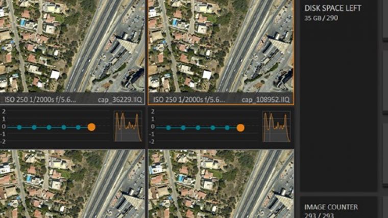
Setting up the camera is easier now with a well-organised display of essential information, including exposure settings, time interval captures, available disk space, GPS data and frame count. A new interface option enables users to choose different skins and font sizes to match the ambient lighting condition of the aircraft and to ease operation on multiple screen sizes and resolutions.
Workflow efficiency
iX Capture 3.0 contains all necessary tools in a single package to enable users to capture, organize and process images into industry standard formats. Its advanced features include up to six camera support for synchronized capture, and the enhanced input data options enable flexible processing of raw or Tiff files into distortion free images. Another improvement is the generation of 3 and 4 Band CIR and NDVI files from images captured by two synchronised and co-installed Phase One RGB and NIR cameras. Further the iX Capture 3.0 allows fully automated processing of 190MP RGB images.
Many additional changes have been implemented to make both the on-board capture experience and post flight processing more efficient. Users can easily follow each capture in real time and control essential settings on Phase One aerial cameras – streamlining the data-acquisition process. By pausing the display of images, operators also can inspect individual captures, zooming up to 100 percent.
For more information about Phase One products see here.

Value staying current with geomatics?
Stay on the map with our expertly curated newsletters.
We provide educational insights, industry updates, and inspiring stories to help you learn, grow, and reach your full potential in your field. Don't miss out - subscribe today and ensure you're always informed, educated, and inspired.
Choose your newsletter(s)


