Piloting the Social Tenure Domain Model in Uganda
Innovative Pro-poor Land Tools under Implementation
By 2030, 60% of the world’s population, or about 5 billion people, will live in urban areas; 78% of them will be in less developed regions. UN-Habitat highlights that the urban slum population is expected to increase to 1.4 billion by 2020. Most people living in slums do not have registered land rights, are not covered by conventional cadastres, and are excluded from other ‘benefits’ of urbanisation. Informal settlements or slums are defined as lacking one or more of the following five conditions: security of tenure, access to water, access to sanitation, durable housing quality and sufficient living space.
Rather than focusing merely on issuing individual freehold titles, the Global Land Tool Network (GLTN) is promoting the concept of a continuum of land rights (Figure 1). Across this continuum, different tenure systems may operate either by individual and/or group claims and may change over time. Conventional land-titling approaches have largely failed to deliver the expected results because the existing technical solutions are expensive, inappropriate for the range of tenure found in developing countries, or unsustainable either financially or in terms of available capacity. Instead, a range of land tenure options is more appropriate. While the concept is incrementally and widely accepted in the global discourse, a new set of land administration and information management systems is necessary to implement and support it. GLTN partners are motivated to assist governments, land professionals and poor communities in both urban and rural areas to improve tenure security at scale and are committed to bridging the identified gaps. By now, stakeholders are aware of the emergence of a potential solution: the Social Tenure Domain Model (STDM). The STDM is a more flexible land information system that can handle various types of land rights and claims, particularly in informal settlements. It is based on a global standard (the Land Administration Domain Model). The STDM is a specialisation of the ISO 19152 Land Administration Domain Model, and this standardisation enables data integration.
Participatory Enumeration
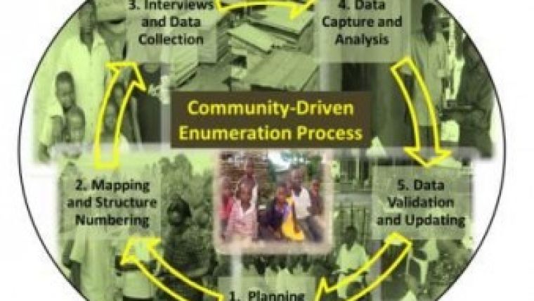
The aim of developing the STDM is to support and implement the concept behind the continuum/range of land rights. A first STDM prototype, developed by UN-Habitat, the International Federation of Surveyors (FIG) and the faculty of Geo-Information Science and Earth Observation (ITC) of the University of Twente, was launched during the FIG Congress in Sydney, Australia, in 2010. UN-Habitat continues to work on its enhancement and further development in three areas: adding more functionality, improving the user-friendliness of the software, and reshaping the STDM to cater for the information needs and requirements of the informal settlements. Data acquisition is performed as participatory enumeration. This is an innovative approach whereby the people who are being enumerated are involved in the inception, design, management, implementation, analysis and use of the data. Participation can provide transparency and build trust: once accepted, local residents can easily co-operate and will provide the information required – resulting in improved data-gathering and better data. Participation means self-empowerment: residents initiate and retain control of the process, and actually own the process. Moreover, women have a critical role in participatory enumeration. The data about informal settlements is needed for a range of purposes: to enable residents to demand their rights as citizens, to improve land tenure, to plan for the provision of infrastructure and services, to redevelop/upgrade the slums, to guide housing improvement, land allocation and adjudication, and to use in land administration and information systems.
The full article is online at http://member.gim-international.com. Please subscribe for free using the Subscribe button in the left hand column.

Value staying current with geomatics?
Stay on the map with our expertly curated newsletters.
We provide educational insights, industry updates, and inspiring stories to help you learn, grow, and reach your full potential in your field. Don't miss out - subscribe today and ensure you're always informed, educated, and inspired.
Choose your newsletter(s)


