Remote sensing for land administration
Innovations based on remotely sensed data
From drones and satellites to airborne-based sensors and Lidar, advances in remote sensing and geospatial information science are driving the development of innovative methods for data acquisition, processing and maintenance. This article looks at how these can support fit-for-purpose land administration.
Land administration (LA) systems, including cadastre and land registration systems, seek to support the management of land value, land tenure, land development and land use planning. These systems are essential for the achievement of the United Nations Sustainable Development Goals (SDGs). Innovative methods for data acquisition, processing and maintenance are being developed to support fit-for-purpose land administration (FFP-LA). These utilize advances in remote sensing and geospatial information science and include uncrewed aerial vehicles (UAVs or ‘drones’), satellite and airborne-based sensors, as well as Lidar – all with high spatial, spectral, radiometric and temporal resolutions. Automatic image orientation, surface reconstruction, scene analysis, change detection, classification and automatic feature extraction – with the help of artificial intelligence, spatial statistics and machine learning – are also being developed.
Proven track record
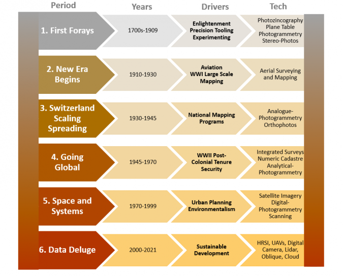
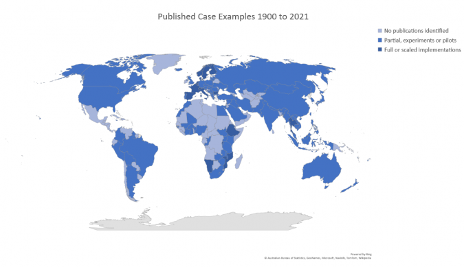
European countries first showed the capability to use photogrammetry to create detailed cadastral maps over a hundred years ago (Figures 1 and 2). Any doubts about the use of photogrammetry and remote sensing for land administration are now hard to justify. That said, ground methods are still predominantly used in many regions. Whether this is because of resistance to change, sector self-interest or cost-benefit analysis is open to debate. Meanwhile, sensor data acquisition, cloud computing and image processing have seen tremendous developments in recent years. Taking all this into account, the surveying communities in different countries must strive to find the best way to integrate imagery-driven cadastral mapping with ground-based methods.
Recent developments demonstrate that ground-based and photogrammetric/remote-sensing techniques are converging. Thanks to digitalization, the distinction between ground and air methods is becoming blurred, with the tools, techniques, data and maps produced, as well as the training programmes, being increasingly integrated.
Remote sensing techniques do not always require intensive technical fieldwork (although a level of face-to-face consultation and sensitization with owners and land users is always necessary). Satellite images or aerial photographs can be employed as base maps for participatory mapping activities where physical features that represent property boundaries – such as roads and paths, connected parcels or buildings – are identified. Studies confirm that boundaries can be located on plotted satellite images and demarcated or outlined via manual or automated feature extraction methods. The resolution of the images must be suitable for the terrain and land use. Satellite images may have drawbacks like inadequate resolution for urban settings, lengthy and costly processing times, or difficulty in obtaining temporally up-to-date data because of frequent cloud coverage, especially in tropical regions. UAVs can help overcome some of these issues and are therefore seen as a viable solution to capture aerial images for further boundary delineation.
In remote sensing for land administration, consideration of ‘invisible boundaries’ is essential. These are legal boundaries that are not visible on the ground (i.e. there are no monuments). Because they effectively exist in the minds of people, they are currently impossible to detect with remote sensing techniques, although further research on this may incorporate prediction of possible locations of invisible boundaries, combined with ground truth survey and human expert knowledge. Despite this challenge, the use of imagery in these contexts is very valuable. Land administration has long recognized the different representations that cadastral boundaries have. They are variously represented as physical natural features, person-made features (stakes or monuments), legal authority, social recognition, textual descriptions (metes and bounds), graphical depictions (be they scaled accurately or not), numerical or coordinated descriptions and, more recently, digital representations. No technological approach can cover all of these aspects. However, remote sensing and photogrammetry can certainly support in some of them.
Rise of UAVs
Over the past decade, UAVs have been a great advantage for both scientific and commercial purposes. Over the past five to six years, the cost and size of UAVs have decreased dramatically, making them a cost-effective way to conduct mapping and research in a short period of time. They have quickly gained importance as a tool for fast collection of high-resolution imagery as base data for cadastral mapping.
UAV-based mapping requires a UAV, pilots and legal permission for the flight mission. The mission consists of three phases: planning the flight, acquiring data, and processing the data. Although the UAV flight is the centrepiece, it takes up only 20% of the total time for the mission; reference data collection and image processing can be two to three times more labour-intensive. Nevertheless, it has been proven that the flight configuration has a significant effect of on the quality of UAV data collected for creating and updating cadastral maps.
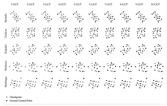
Experiments in Europe and Africa have assessed the impact of land cover, the setup of ground control points (GCPs) and flight plans on the accuracy and completeness of automatically detected cadastral features. The results indicate that each of these factors has a major influence on the final data quality. The accuracy and completeness of automatically detected cadastral features can vary greatly between orthophotos generated from different flight plans.
Improving UAV data collection
Some of the key recommendations for land professionals for improving existing and future UAV data collection workflows are summarized as follows:
- Land use can greatly influence the number of tie points in an image. For scenes with a high percentage of vegetation, such as trees or forests, an overlap of 80-90% is necessary to ensure sufficient image correspondences.
- Regardless of the size of the study area, the level of error in planimetric and vertical residuals is consistent when seven GCPs are evenly distributed (as outlined in Figure 3) and the forward overlap and side overlap are both at least 70%. Since additional GCPs do not significantly alter the absolute accuracy, seven GCPs are the optimal survey design.
- The quality of reconstructed thin cadastral objects, such as concrete walls, is highly dependent on the flight configuration. Increasing the image overlap improved the reliability of generated orthophotos. On the other hand, the delineation results of rooftops showed less sensitivity to the flight configuration.
- Checkpoint residuals may indicate a high absolute accuracy of an orthophoto. However, it is important to measure them in the generated orthophoto in addition to after the bundle block adjustment (BBA) in order to accurately assess the reliability of reconstructed scene objects, particularly in adverse conditions with large variations in the height component.
The findings of this analysis have major implications for the use of UAVs in land administration tasks. There is the risk that UAVs are used without an understanding of the photogrammetric principles and the available options to customize flight configurations. This can lead to good-quality end products, but with spatial offsets, deformations or poor reconstruction results of relevant features going undetected. At the same time, however, the results of this analysis opened up immense opportunities for customizing UAV workflows. Different flight configurations and various reference data provide a range of options to fit the data collection task to the financial, personnel and time capabilities, while also meeting customer needs and requirements in the land sector. This makes UAV workflows a viable and sustainable tool to deliver reliable and cost-effective information for current and future cadastral challenges.
GeoAI and deep learning
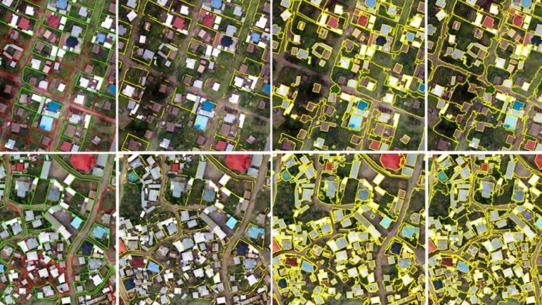
The concept of using remote sensing imagery to delineate visible cadastral boundaries has been gaining interest in recent years. This has resulted in increased activity in automated methods for extracting such boundaries. Recent research on artificial intelligence (AI), machine learning or even more particularly on deep learning and remote sensing imagery for the purpose of cadastral boundary extraction has been encouraging. The traditional unsupervised methods heavily rely on parameter tuning such as the shape, colour and size of the desired segmented objects. These were developed by combining several parameters as input – including scale, compactness, layer weight and shape/colour – to predict segmented vector polygons. A variety of outputs have been explored based on these methods, such as images in which every pixel value represents a probability of boundary or output is in the form of closed pixel contours. In contrast to the traditional unsupervised methods, supervised methods use trainable networks that take labelled data as model input. The effectiveness of traditional unsupervised and supervised methods has been demonstrated, particularly when input data is limited. On the other hand, when large datasets are available, deep learning is often the more appropriate choice.
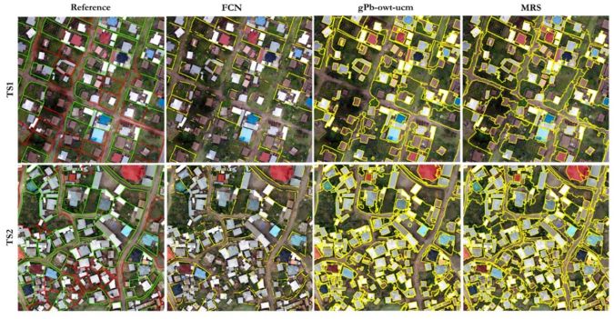
Deep learning models are composed of multiple layers that learn data representations at different levels of abstraction, starting from pixels, corners and edges and progressing up to complex spatial patterns. One deep learning architecture often used in image classification is the convolutional neural network (CNN). A special type of CNN is the so-called fully convolutional network (FCN), which is designed to perform semantic image segmentation. Both methods have been proven to be promising for boundary delineation, However, the success of the final result highly depends on the visibility of the physically demarcated boundaries on the image. A comparison between different methods for automatic boundary extraction also indicated the outperformance of the machine learning methods (Figures 4 and 5).
Compared with traditional methods, the most significant advantage of deep learning models is that all representations are learned in a supervised way and not handcrafted by a human operator. There is a clear need for further method development, especially in the direction of detection or prediction of the location of invisible cadastral boundaries.
A new role for Lidar
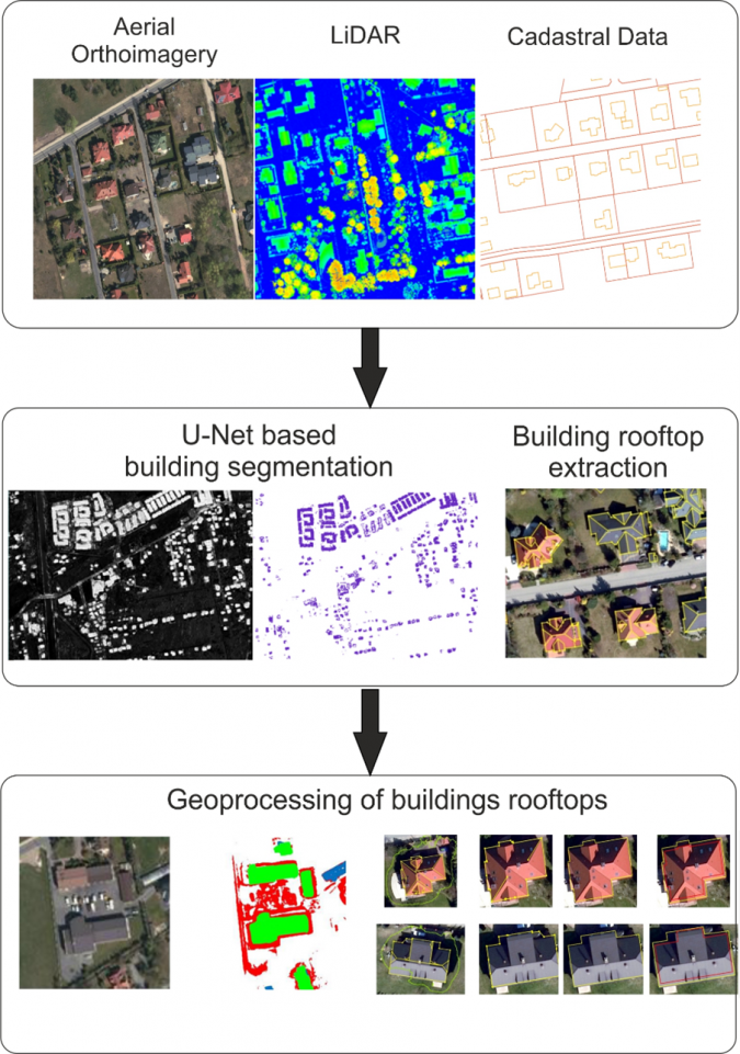
Significant work has looked at the role of Lidar in cadastral mapping. In Poland, an automated system for extracting outlines of building rooftops was proposed based on a modified U-Net deep learning algorithm. This algorithm was designed to provide accurate rooftop segmentation with a limited number of training images. The feature map size of the U-Net architecture used was 416 × 416 × 1, and the analysis was performed with publicly available data, consisting of orthoimagery and densely classified Lidar data in a digital surface model (DSM).
The utilization of deep learning techniques, high-resolution aerial imagery and land administration data (from laser scanning) can provide an efficient and cost-effective method for obtaining building outlines for cadastral purposes. Although the automatically extracted outlines cannot be directly implemented into the cadastral data due to discrepancies between the ground and roof outlines, they can still be utilized in the process of cadastral modernization. The experiment revealed that the proposed approach produces satisfactory results and is adaptable when the parameters are adjusted to the region’s buildings. However, this may not be applicable to other areas with different building characteristics.
Cost-effective and fairer
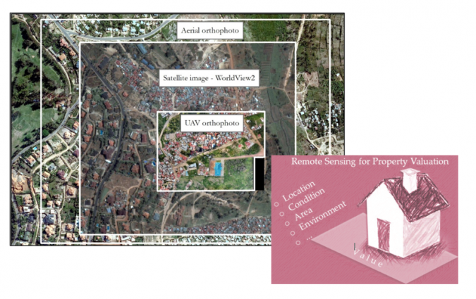
Taking another case application beyond cadastral or tenure boundaries, property valuation – a fundamental element of land administration – is usually determined by a range of factors such as geographic location, physical characteristics, legal implications and economic considerations. While property valuation is essential for economic growth, many developing countries often lack official regulations or specific data requirements. Therefore, a study in Rwanda explored the effectiveness with regards to taxation of three remote sensing technologies: 1) aerial images captured with a digital camera, 2) WorldView2 satellite images, and 3) UAV images obtained with a DJI Phantom 2 Vision Plus quadcopter. UAVs were shown to offer the most promising method for collecting data to support property valuation for taxation. They could provide accurate and up-to-date information, which is essential for fair taxation.
Although past trends may not be reliable predictors of future progress, the expanding use of remote sensing technologies in land administration appears to be undeniable. Digital transformation is lowering the legal and institutional barriers to change, allowing start-ups and other land administration service providers to enter the market more easily. AI and feature extraction techniques will continue to be utilized and fused with other data sources, such as statutory and non-statutory as well as social and environmental data, to create more advanced boundary recognition algorithms. That said, people will remain central to the processes. In the end, it is they who must determine, use and enforce boundaries.

Value staying current with geomatics?
Stay on the map with our expertly curated newsletters.
We provide educational insights, industry updates, and inspiring stories to help you learn, grow, and reach your full potential in your field. Don't miss out - subscribe today and ensure you're always informed, educated, and inspired.
Choose your newsletter(s)


