Satellite-derived bathymetry for surveying Jamaica’s coastal waters
Towards time efficiencies, cost savings and improved safety
The national land agency in Jamaica has integrated satellite-based hydrography to benefit from time efficiencies, cost savings and improved safety as part of its hydrographic programme in support of the nation’s further economic development.
Central America and the Caribbean region are blessed with beautiful coastal waters. However, most nations, if not all, face the arduous task of developing and managing their natural resources, such as the marine environment, while focusing on economic development. Under the International Convention for the Safety of Life at Sea (SOLAS), Jamaica is responsible for executing hydrographic surveys of its coastal waters. The National Land Agency (NLA), the recognized national hydrographic office, has a hydrographic survey programme in place to cover the bathymetry of Jamaica’s coastal waters in fulfilment of its responsibility to collect, maintain and disseminate nautical information to all its stakeholders. Through a contractual arrangement, Jamaica’s admiralty charts are produced and maintained by the United Kingdom Hydrographic Office (UKHO). The acquisition of refined, reliable and enhanced hydrographic information in Jamaica’s territorial waters supports Jamaica’s development as a nation, tapping further into the blue economy.
Background to the National Land Agency (NLA)
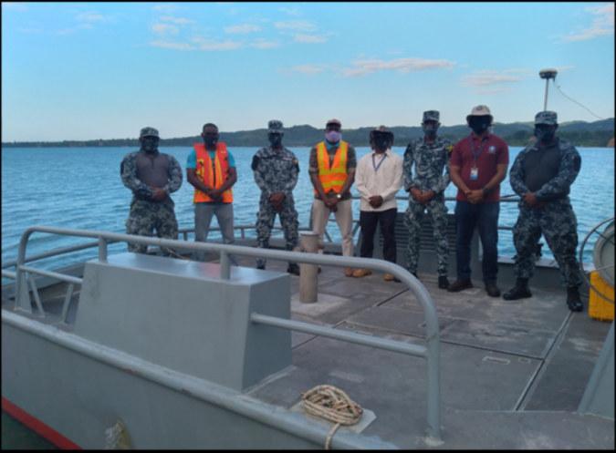
Under the Surveys and Mapping Division (SMD), the NLA is responsible for carrying out hydrographic surveys of Jamaica’s harbours and territorial waters. The NLA is the national hydrographic office recognized by the International Hydrographic Organization (IHO). While operating under resource constraints, as with most small island developing states, the SMD is tasked with surveying Jamaica’s coastal waters. Nonetheless, an intergovernmental agency partnership has been brokered through the National Hydrographic Committee (NHC), resulting in an agreement for the use of a Jamaica Defence Force Coast Guard vessel, which was utilized in the recent survey of Bowden Harbour in St. Thomas.
Port Morant (Bowden) Harbour single-beam sonar bathymetric survey
The NLA conducted a single-beam hydrographic survey of Port Morant (Bowden) Harbour in December 2020. The purpose of the survey was to collect hydrographic data of the harbour to aid the update of Admiralty Chart number 275-3 and fulfil other hydrographic needs. The survey covered an area of approximately 3.4 square kilometres (340 hectares). The line spacing for the development lines was 20m, which ran perpendicular to the depth contours. Approximately 171 development lines (planned lines) and 43 check lines were generated for the survey area. The survey was carried out over ten days, collecting sonar data from 06:00 to 18:00.
A considerable amount of human and capital resources are required for the execution of a successful traditional single-beam sonar survey (SBSS) or multibeam sonar survey (MBSS). As can be seen in Figure 2, eight people were involved in the data collection for this project. The Jamaica Defence Force Coast Guard provided four boat crew coxswain and boat aids, while the NLA provided four people as part of the data acquisition team.
Collaboration: National Land Agency and TCarta Caribe
The Bowden Harbour Project presented an excellent opportunity as a case study into the usefulness of satellite-derived bathymetry (SDB) to improve the efficiency of hydrographic surveys, as the SDB data was readily available through TCarta. Additionally, the team wanted to test the potential for SDB to support single beam surveys. TCarta Caribe provided the NLA with the SDB of Bowden Harbour to carry out the investigation.
TCarta and the NLA also teamed up after the survey for a capacity-building workshop, presented by TCarta, to address three objectives: (1) the SDB’s potential to inform hydrographic survey planning; (2) to describe/explain SDB production methods; and (3) to perform data analysis and comparisons between a single beam derived surface and that of the SDB for Bowden Harbour.
TCarta’s team advised that, as the SDB software is integrated into ESRI in ArcGIS Pro, and as the NLA already uses ArcGIS Pro, it would be a natural progression for the Carta’s NLA to build its marine spatial data infrastructure within this platform.
The workshop continued with a session on the process of producing SDB using TCarta proprietary software, the Multispectral Bathymetry Tool (MBT) in ArcGIS Pro. In addition, the workshop focused on the process involved in the production of SDB in Bowden Harbour and gave an overview of SDB’s feasibility in Jamaica’s coastal waters. The final session zeroed in on the statistical analysis of SDB in comparison to NLA single beam data.
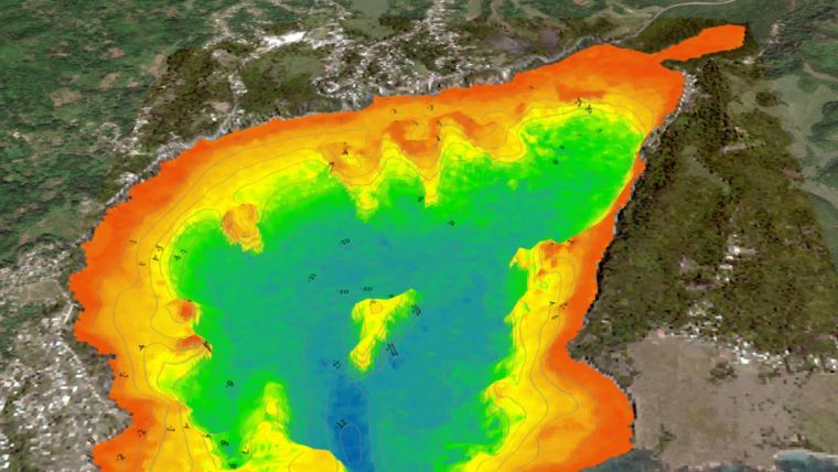
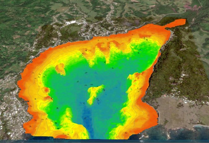
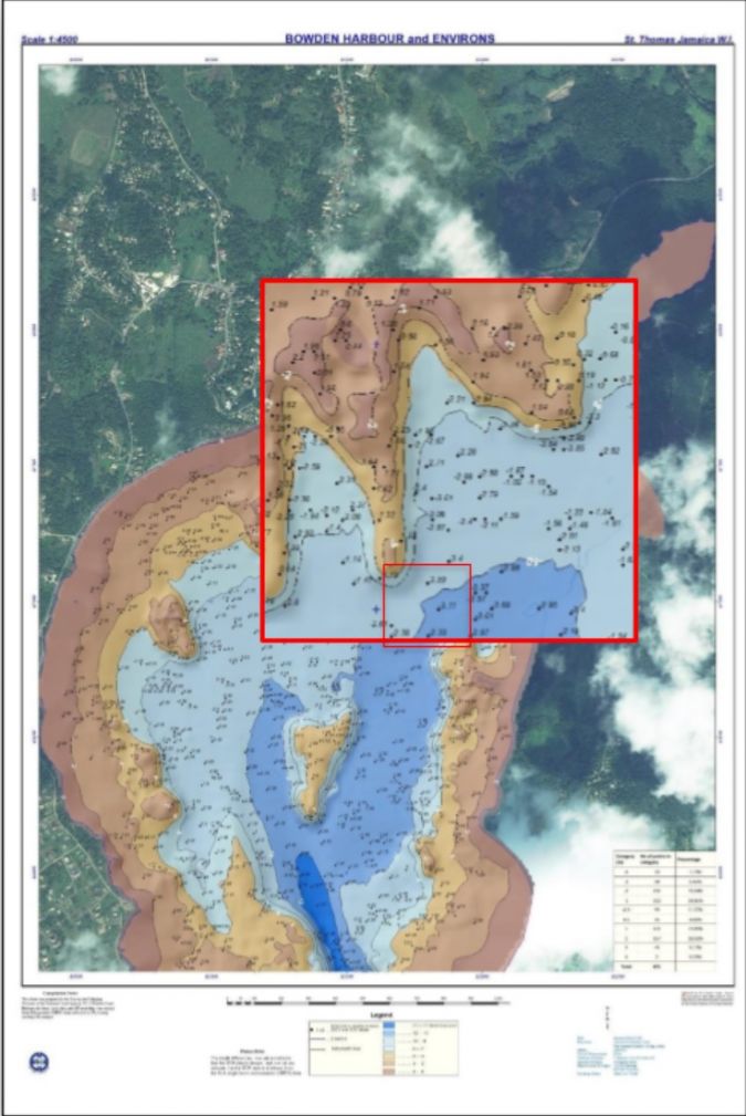
TCarta used three NLA transect lines, as ground ‘truthing’, for the correction of the SDB data, from which a surface was produced (see Figure 3). A graphic representation of the SDB-derived data is shown in Figure 4, highlighting the usefulness of planning survey lines and mapping areas of caution.
TCarta SDB vs NLA SBES
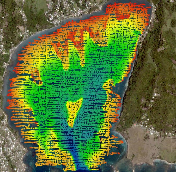
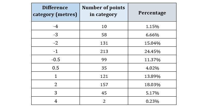
The NLA’s GIS unit created a difference map of the single beam echo sounder (SBES) data versus the TCarta SDB data. Preceding the creation of the difference map, TCarta applied a datum adjustment to the SDB, adjusting the SDB depths to the local mean low water (MLW) datum, approximately 0.25m above lowest astronomical tide (LAT). A point-to-point comparison was carried out by the NLA’s team using ArcGIS, analysing 871 congruent points. The results show that 15.39% of the points had a difference of ±0.5m, while 86.80% had a difference within ±2 metres (see Table 1).
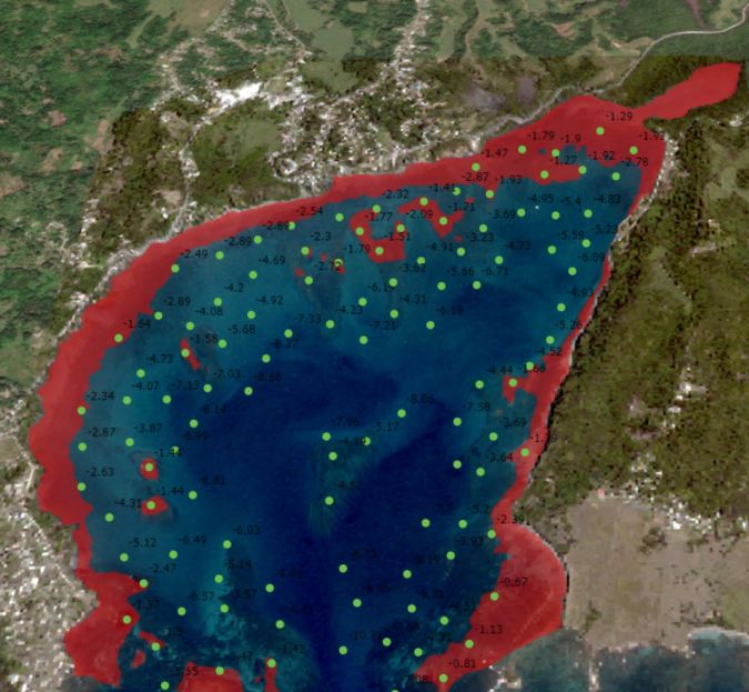
With the generation of the difference map, an analysis could be made of the general agreement between the data, cross-referencing these differences with the seafloor topology and identifying possible trends at various depth ranges (see Figure 5). The differences between the NLA SBES data and the TCarta SDB data are shown as spot heights. Positive (+) differences (58.67%) indicate that the SDB data is deeper and negative (–) differences (41.33%) indicate that the SDB data is shallower than the NLA SBES data.
NLA also analysed ten particular areas with varying seafloor topology. The general trend indicates that SDB data tends to be shallower in deeper water and deeper in shallow water, compared to NLA’s SBES data.
Discussion
The SDB technology was found to give a general indication of the depths within the project area. SDB gradually detects changes in depths; in other words, it ‘smooths’ the changes in depth and will not detect sudden outcrops or rocks. As such, SDB is a useful tool for filling in the gaps. These could be gaps between survey lines with respect to SBES or gaps in depths to the zero-depth contour, which are hard to survey with typical survey vessels, therefore improving on the spatial resolution. SDB is an excellent tool for planning and conducting feasibility studies of traditional bathymetric surveys to be undertaken, especially where inadequate chart data exists.
SDB technology can be a catalyst for the mapping of Jamaica’s coastal waters, which is vital to the blue economy and to further aid our understanding of climate change and other environmental impacts. With the current focus of the region on the Seabed 2030 initiative, which aims to survey the ocean floor by the year 2030, there is much demand for bathymetric data in the region. The current pandemic has seen already limited resources being diverted to the health sector, and those resources that are allocated to the marine environment must be used as efficiently as possible. Some countries have also seen the limited mobilization of hydrographic survey teams, to reduce costs as well as to reduce the spread of COVID-19. Collaborative approaches, such as the integration of SDB with traditional survey methods, is one approach that can aid the realization of the Seabed 2030 initiative.
The integration of satellite-based hydrography, which promotes time efficiencies, cost savings and improved safety, lends itself to the development of the NLA’s hydrographic programme. This collaboration and integration of technologies goes hand in hand with the NLA’s commitment to research and development.
Conclusion
SDB is a quick and inexpensive way to obtain a general idea of depths for applications such as fisheries and post-disaster response and rescue planning. It can be used as a tool for planning and conducting feasibility studies of traditional bathymetric surveys, but the vessel should navigate with the utmost care where the underkeel clearance is calculated to be less than five metres.

Value staying current with geomatics?
Stay on the map with our expertly curated newsletters.
We provide educational insights, industry updates, and inspiring stories to help you learn, grow, and reach your full potential in your field. Don't miss out - subscribe today and ensure you're always informed, educated, and inspired.
Choose your newsletter(s)


