Scanning 100 Dutch Railway Stations
Geomaat recently performed extensive 3D laser scanning and 3D modelling for the Dutch railway organization, ProRail.
ProRail is the organization that takes care of the entire railway network in the Netherlands, from construction to maintenance. It is essential that the data in the ‘Basic Management Map’ (Basisbeheerkaart), which is used to manage the network, is up to date at all times. ProRail works with various suppliers to map the railway network. One of those suppliers is Geomaat, which recently supported Arcadis on a ProRail project in order to add its own experience in 3D laser scanning and 3D modelling to Arcadis’ extensive railway-related expertise.
Complex Large-scale Project
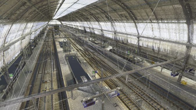
ProRail launched a project to bring – and keep – all the maps used to manage the rail network, including all railway stations, up to date. The project has been divided into three parts. The first part entails an aircraft flying above all the railway lines and stations. The second part entails scanning all objects in the vicinity of the rail network that are not visible from the air, such as in the covered areas at railway stations. The third part entails updating the Basic Management Map and processing all the gathered data (to incorporate the mutations). Geomaat is responsible for executing the second part, and Arcadis is incorporating the data into the Basic Management Map in the third part of the project.
Due to the huge scale of the project, an efficient workflow is essential. Geomaat drew up a plan of attack for scanning all the stations, based on four components per station: preparation, scanning, data processing and quality control. Needless to say, numerous safety risks are associated with working at railway stations, which is why all project members received safety training. Additionally, Geomaat informed each station manager about all the scanning activities in advance.
Meeting High Demands
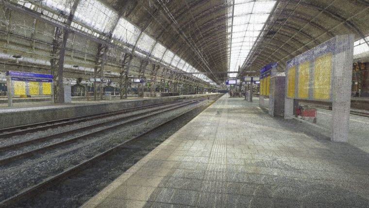
ProRail can only work with data that contains a high level of accuracy. Additionally, the project is complex due to its large scale. Therefore, Geomaat provided a smart solution in order to meet ProRail’s high quality demands in terms of the 360-degree images and also the 3D point cloud. Geomaat had to be inventive because there is no scanner currently available on the market that can deliver the images and point cloud with the required accuracy. In order to meet the client’s needs, Geomaat conducted its own research and came up with an effective solution: a combination of a Leica RTC360 laser scanner with a separate high-resolution camera.
“Those new scanners have made it possible to create the point cloud from the gathered data directly in the field. Besides that, we purchased a high-resolution camera so that we can capture even better 360-degree images,” states Ernst ten Napel, project leader geo.
The success of this method is not without its challenges, such as different centre points and the extrapolation of the right rotation parameters. These are then converted into transformation vectors in order to incorporate the 360-degree images correctly. Geomaat has developed its own innovative way of doing this using tooling, as outlined below.
Innovative Tooling
Geomaat supplies ProRail with a coloured RD/NAP-registered point cloud including the 360-degree images. The 360-degree images are incorporated into the point cloud with the utmost accuracy, because the photos and the point cloud must be an extremely precise ‘fit’ so that the point cloud can be accurately overlaid with the natural colours from the photos. However, the photos are not necessarily used horizontally. One of the characteristics of a 360-degree image is that it does not have a horizontal plane, nor does it have a fixed orientation such as north on a map. Geomaat’s Research & Development department develops tools that simplify and improve workflows, and it produced such a tool for the ProRail project: “ProRail requires the panoramic images with north-up orientation so that they can also be used in its own software. A panoramic photo is made up of eight partial images, which means that all those images have to be corrected without altering the how they relate to one another. Matrix calculations are used to determine the rotation parameters for each partial image. This entails rotating the images around three axes, so that the panoramic photo has north-up orientation and all the partial images still fit together seamlessly,” says Joukje de Haan, process & innovation specialist.
Checking Data
It is very important to get the basics right in order to achieve the required quality, which is why Geomaat has made quality checks a top priority in the ProRail project, according to Niels Domhof, 3D specialist: “We perform lots of checks on the captured data. We always take cross sections along the x, y and z axes, so that we can make sure that all data is well aligned. We also remove all organic elements from the point cloud so that it is nice and clean. To link the registered point cloud to the RD/NAP network, ground control points have been set up at the stations. We also work in line with the four-eyes principle, which means that each point cloud is always examined separately by two different 3D specialists to ensure thorough quality control.”
Coronavirus
The coronavirus pandemic has created many extra challenges in everyday life, but has actually proved advantageous for the project in some ways, continues Domhof: “It might sound strange, but the coronavirus outbreak actually came at a good time for this project. It meant that fewer people were present at railway stations and there were hardly any trains on the tracks. As a result, our point clouds were much ‘cleaner’ and we had to remove very few organic objects. Before the pandemic started, we captured Utrecht Central Station. We chose to do so on 2, 3 and 4 January because most people are still off work for the Christmas holiday so it’s a lot quieter than normal. You have to be very flexible in terms of planning when working on such a large-scale project.”
Why Geomaat?
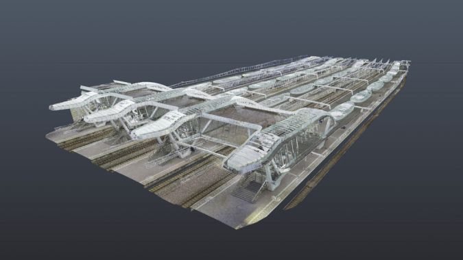
Arcadis approached Geomaat because of its broad knowledge and experience. Over the years, Geomaat has captured approximately 50 railway stations, for various clients. The aim of this project was to gain an overview of the station equipment. Geomaat has developed a 3D BIM model from the point clouds so that ProRail can easily overlay the map of the ‘old’ situation with the new situation in three dimensions.
Completion
Geomaat has since completed all the outdoor scans scheduled for the first year. “We’re now in the final phase of completion and preparing the mutation scans,” says Ernst ten Napel, project leader.

Value staying current with geomatics?
Stay on the map with our expertly curated newsletters.
We provide educational insights, industry updates, and inspiring stories to help you learn, grow, and reach your full potential in your field. Don't miss out - subscribe today and ensure you're always informed, educated, and inspired.
Choose your newsletter(s)


