3D Laser Mapping for Waste Monitoring
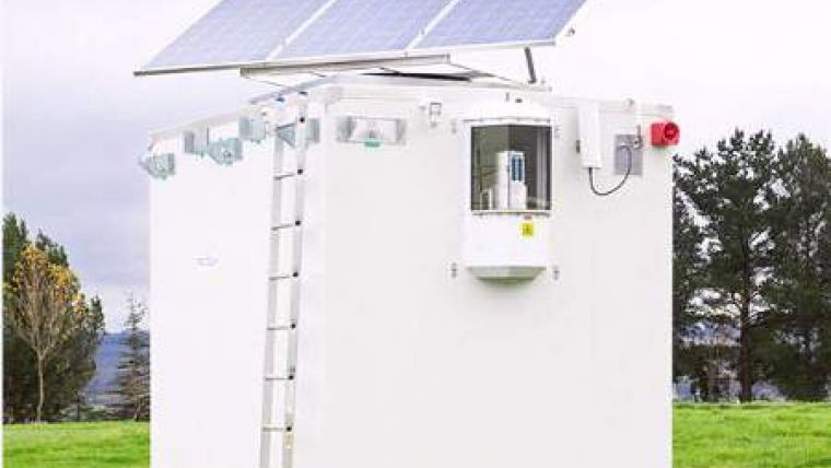
A laser scanning system is to improve safety of iron ore extraction in South Africa. The Riegl laser scanner forms an integral part of a Waste Spreader Positioning System (WSPS) developed by Stone Three Venture Technology in partnership with Reutech Mining. The WSPS is designed to ensure the safety of machine operators by calculating a safe zone of operation on the mine heap and monitoring the activities of the Waste Spreader within this defined zone.
The Riegl LMS-Z210ii, supplied by 3D Laser Mapping, is a rugged sensor designed for the rapid acquisition of high-quality 3D images in the harshest and most demanding environmental conditions. With a range of up to 650 metres and accuracies of 10 millimetres the scanner is mounted on a self-sufficient semi mobile platform from where it is used to monitor the expanding waste heap. The 3D scans of the expanding waste heap are then transferred, via a Wireless Local Area Network, to a central server where they are used to calculate a safe boundary around the top of the waste heap.
A highly accurate Global Positioning System (GPS) receiver mounted on the Waste Spreader determines the position of the machine in relation to the pre-determined safe zone. This information is displayed on screen in central control room and should the Waste Spreader cross the safety boundary an audio visual alarm is automatically triggered to warn both the machine operator and control room staff.

Value staying current with geomatics?
Stay on the map with our expertly curated newsletters.
We provide educational insights, industry updates, and inspiring stories to help you learn, grow, and reach your full potential in your field. Don't miss out - subscribe today and ensure you're always informed, educated, and inspired.
Choose your newsletter(s)


