3D Robotics Launches New 3DR Mapping Platforms
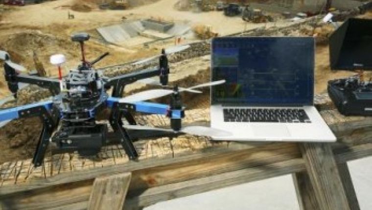
3D Robotics, a North American UAV company, has announced the launch of the new 3DR mapping platforms, consisting of the 3DR X8-M (multi-copter) and Aero-M (fixed-wing), with highly accurate resolution that allows users to zoom in from the sky “down to the grape.” Each platform is bundled with both hardware and software solutions, including a high-resolution visible-spectrum camera, protective hard-case, auto-pilot controlled image acquisition and professional image processing software powered by Pix4D, 3DR’s newest business partner.
The new 3DR mapping platforms have a simple, fully automated three-step workflow: plan, fly, process. The flight planning software computes flight paths over a selected area to survey and calculate exactly which pictures to take and when. While in flight, the drones automatically capture those images and geo-tag each capture to note the exact location. When the drone lands, the user immediately has a series of crisp and accurate images that can then be geo-referenced by the Pix4D software to automatically create a high-resolution, ortho-rectified 2D mosaic map (or 3D model depending on the chosen edition) that delivers accurate and immediately actionable data.
Applications
This level of aerial perspective is invaluable on farms, construction sites and mines. It enables enhanced crop and water usage understanding, increased perspective and knowledge of building material movement, equipment locations, construction progress and mining area status. 3DR mapping platforms are developed to save users money through on-demand, high frequency monitoring, and enable them to take informed and targeted action in any of the above applications. In conservation and land and resource management applications, the platforms can increase understanding of how we use precious land and water resources.
The X8-M offers low-flying and high accuracy mapping, with a fully redundant propulsion system for increased reliability. The Aero-M fixed-wing platform offers incredible endurance and coverage area, with 40 minutes of flight and 250 acres of coverage. With these low-cost, high-accuracy platforms, professionals will maximise budget and improve response time by not waiting to schedule satellite imagery or incurring the expense and risk of using manned aircraft to gather data.
For more information on the features of 3DR mapping platforms, see the company’s website.

Value staying current with geomatics?
Stay on the map with our expertly curated newsletters.
We provide educational insights, industry updates, and inspiring stories to help you learn, grow, and reach your full potential in your field. Don't miss out - subscribe today and ensure you're always informed, educated, and inspired.
Choose your newsletter(s)


