7 Digital Twin Articles All Chief Digital Officers Should Read
Today’s digital revolution is leading to a huge amount of geospatial data. A digital twin is a digital, three-dimensional copy of a real-life environment – e.g. a city, building, railway project or crop field – in which all available geospatial data is presented in a location-oriented and object-oriented manner. Here, we present a series of inspiring articles providing examples of how your organization could use a digital twin in practice.
Bridging the Gap between Geospatial and Construction
There is certainly a gap in information exchange between the geospatial and construction domains. This is a serious issue, mainly because geospatial systems and engineering surveys are not yet aligned and integrated with building information modelling (BIM). The BIM method is expected to move construction activities from plan-based individual work to model-based collaboration. Such a paradigm shift will bring huge opportunities regarding planning, building and management of the built environment in a more productive, open and sustainable way. Although it is still difficult to entirely close the gap between these two fields, this article shows how that gap can at least be narrowed.
Point Clouds – the Representation of the Third Kind
GIM International has published – and will no doubt continue to publish – many articles about point clouds: huge collections of (surface) points. Taken together, they represent the world at its best: up to date, and with every detail there is to be known. Most articles pay particular attention to the data acquisition of such point clouds, as they are obtained from 1) Lidar time-stamped reflections with the advantage of indicating ‘empty’ space between the observation point(s) and surface points, and 2) images by structure from motion (SfM) and dense image matching (DIM) techniques with the benefit of colour-enriched points. In this column, Edward Verbree explains why he believes point clouds should be considered as the third kind of representation, alongside polyhedral surface representations and volumetric voxel representations.
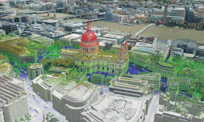
State of the Art in 3D City Modelling
Semantically enriched 3D city models have the potential to be powerful hubs of integrated information for computer-based urban spatial analysis. This article presents the state of the art in 3D city modelling in the context of broader developments such as smart cities and digital twins, and outlines six challenges that must be overcome before 3D data as a platform becomes a reality.
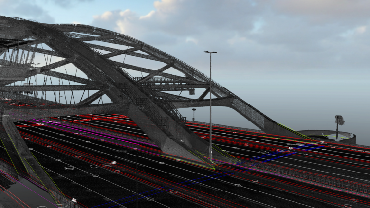
How Geospatial Data Supports a Digital Railway Project
The scope of the Rail Baltica Global Project comprises 870km of tracks, 25km of major structures and more than 400 bridge structures (bridge, overpasses, viaducts, pedestrian crossings and animal crossings), as well as three freight terminals and seven international passenger stations. Besides that, there are rolling stock maintenance facilities, an energy subsystem and signalling. This article zooms in on the pivotal role geospatial technology plays in the BIM strategy that underpins the digital version of Rail Baltica.
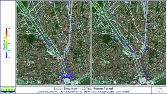
City-scale Digital Twins for Flood Resilience
Extreme weather events and rising populations are straining existing (and often inadequate) drainage infrastructure in cities around the world. The result is flooding that damages property and infrastructure, impacts human safety and weakens economies. Digital twins can help cities plan for disasters and will enable them to better respond to weather events.
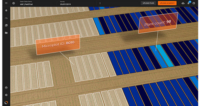
The Benefits of Visual Intelligence Solutions in Agriculture and Forestry
Visual intelligence solutions for agriculture and forestry provide easy access to digital maps of fields, forests or plantations. In turn, this opens a world of opportunities, including the ability to take measurements ranging from phenotype microplot traits to forest inventory. Additionally, users can identify early signs of stress in large plantations, generate precise, ready-to-use weed control maps, and follow the evolution of the assets over time. This article illustrates how digital twins optimize the workflows for key agriculture and forestry activities based on real-world applications.
Simultaneous Capturing of Lidar and Imagery
People continue to migrate from rural areas to major cities, driving sustained urban growth and increasing the demand for accurate, detailed and up-to-date 3D city models. The creation of such models is still a cumbersome endeavour but new advancements, such as the combination of three sensor types – nadir camera, oblique cameras and a Lidar unit – in one and the same geodata acquisition system, may bring relief. Aerial surveys conducted in major cities in the UK and Ireland demonstrate the potential of this solution.

Value staying current with geomatics?
Stay on the map with our expertly curated newsletters.
We provide educational insights, industry updates, and inspiring stories to help you learn, grow, and reach your full potential in your field. Don't miss out - subscribe today and ensure you're always informed, educated, and inspired.
Choose your newsletter(s)


